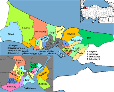
Sarıyer
| Sarıyer | |
|---|---|
| district | |
|
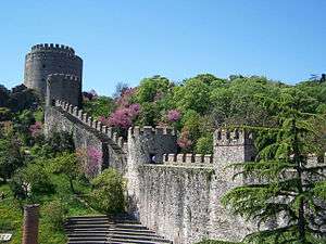
Rumelihisarı in Sarıyer | |
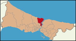 Location of Sarıyer in Istanbul | |
 Sarıyer Location of Sarıyer in Istanbul | |
| Coordinates: 41°11′28″N 29°00′34″E / 41.19111°N 29.00944°ECoordinates: 41°11′28″N 29°00′34″E / 41.19111°N 29.00944°E | |
| Country | Turkey |
| City | Istanbul |
| Government | |
| • Mayor | Şükrü Genç (CHP) |
| • Governor | Mehmet Ersoy |
| Area[1] | |
| • District | 161.92 km2 (62.52 sq mi) |
| Population (2012)[2] | |
| • Urban | 258,035 |
| • District | 289,959 |
| • District density | 1,800/km2 (4,600/sq mi) |
| Time zone | EET (UTC+2) |
| • Summer (DST) | EEST (UTC+3) |
| Area code(s) | 0–212 |
| Website |
www |
Sarıyer (pronounced [saˈɾɯjeɾ]) is the northernmost district of Istanbul, Turkey, on the European side of the city. With a long shore along the water, the district boasts both a beautiful coastline and a lush forest. The Sarıyer district is a huge area consisting of the villages on the European side of the Bosphorus from Rumelifeneri, down through Tarabya, Yeniköy, İstinye, Emirgan to Rumelihisarı. Sarıyer also administers the Black Sea coast to the west of the mouth of the Bosphorus including the village of Kilyos. Its neighbours are Eyüp the northwest, Beşiktaş the south and Kağıthane the west. Sarıyer has a population of approximately 260,000. The mayor is Şükrü Genç (CHP). Some parts of Beyoğlu and Çatalca was joined and Sarıyer became district centre in 1930. District boundaries were shrunk after county of Kemerburgaz was given to Eyüp in 1936 and villages of Maslak and Ayazağa were given to Şişli in 1954. Sarıyer has present boundaries after joining boroughs of Maslak, Ayazağa and Huzur from Şişli district in 2012.
The North Bosphorus
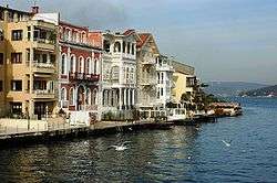

Sarıyer's Bosphorus villages, backed by steep hills, were once rural fishing communities. They later became retreats for the city's wealthy. In the Ottoman period the sultans came to these villages for picnics and excursions. During the 18th and 19th centuries, the coast was lined with summer residences of the wealthy foreign traders of Pera and Galata. Many foreign embassies built summer residences in this period. Since the construction of the coast road, these villages, and increasingly the hillsides behind them, house many expensive villas owned by İstanbul's rich businessmen, actors and musicians, attracted by the coastline and the lush forest behind.
Sarıyer has recently been supplied with natural gas. Significant parts of the district have also seen the installation of a new drainage system, particularly in the village of Sarıyer itself and along the coast road. These projects have led to chronic road construction and its attendant traffic. Sarıyer itself has particularly heavy traffic.
The coast road running through Sarıyer is lined with fish restaurants of all kinds, ranging from the most elegant to equally delicious small restaurants, many of which were formerly housed in boats moored by the sea wall. Unfortunately this coast is so popular with day-trippers and Sunday drivers that at weekends the pleasure of a drive along Sarıyer's is mitigated by the crawling queues of traffic.
In addition to the coast road, Sarıyer is connected to the downtown historic and financial centers by Buyukdere Road, the main road from Beşiktaş up to Maslak and beyond; this is the route used by minibuses serving Sarıyer-Beşiktaş. There is also high-speed ferry boat service for commuting to the city. However, as a drive through Sarıyer during commute times and rush hour will attest, many people commute by car.
The Bosphorus communities of Sarıyer include (south to north):
- Emirgan is former retreat from the city, backed by a hillside still green despite the recent construction of villas within it. The district is named for the Ottoman lords (Emirs) that came here on excursions. There is a lovely square in the center, shaded by a huge plane tree, with a cafe in the middle. Home to the Sakıp Sabancı Museum.
- Reşitpaşa is a crowded district on the hill above Emirgan. It is a big village, with attractive villas and lots of illegal gecekondu housing on a forested hillside. The modern campus of the Istanbul Stock Exchange is nearby, as are one campus of the Istanbul Technical University and a large new mall, Istinye Park.
- Istinye is a fishing port, which once contained a shipyard, with a village behind and tea gardens by the sea. As in so many other areas, luxury condos now rise from Istinye's hillsides. In 2003 the imposing American consulate was built here. The town's stream was once polluted with sewage. The stream is now biologically treated to eradicate any effluent to the Bosphorus.
- Yeniköy consists of luxury villas on a hillside and a small area of tightly packed old houses near the sea. The latter area, the old village, has a longstanding Greek community, evidenced by its Orthodox churches. Yeniköy's long-established cafes and bakeries lends to a cosmopolitan feeling reminiscent of old Istanbul. Former prime minister Tansu Çiller lives in a town-house on the seafront. In recent years Yeniköy has acquired a community of Filipinos, working as domestic help in the big villas.
- Tarabya was formerly the Greek Theràpia, the name of which comes from the Greek word therapeia (therapy) and indicates the area's former use as a sanctuary from the city for the sick. It is now a classy neighbourhood, dominated by the once grand Tarabya Hotel. There are fish restaurants and 'taverna' featuring traditional Turkish music, drink, and atmosphhere. Marmara University has a small site here, teaching French, housed in a villa built by Alexander Ypsilantis. A stream once flowed to the Bosphorus, but is now covered by concrete. Tarabya also is home to the German consulate.
- Büyükdere was formerly the Greek-Byzantine Vathys Kòlpos District, 'the deep gulf' in Greek). It was originally a quiet residential area composed mostly of old, quiet neighborhoods. However, recent years have seen the construction of expensive apartments and condominiums. Home to a number of churches, the Spanish and Russian summer consulates and the Sadberk Hanim Museum. There are places to sit by the Bosphorus and sip tea.
- Bahçeköy was formerly the Byzantine Petra district. One of the northern villages of Sarıyer. After Suleiman the Magnificent came back from Belgrade, he settled the Serbs in the nearby forest, which has since been known as the "Belgrade" Forest (Belgrad Ormanı.) In the 19th century, the village was inside the Belgrad Forest but due to the latter's retreat before development, Bahçeköy now sits on the forest's edge. Atatürk Arboretum is in Bahçeköy.
- Sarıyer itself is a traditional rural and working-class Turkish town, lacking in infrastructure, it is relaxed, friendly and has a high proportion of retired residents. You will see them taking long walks along the Bosphorus. Fishing is still practiced in its small harbor. The industry feeds the local fish market and a long line of famous fish restaurants. There are also a variety of cafés, kebab houses and bars, where many of İstanbul's residents come to eat and drink on weekends. Many of the restaurants are owned by famous musicians, who sometimes put on live shows for customers.
The forest hinterland
The Belgrad Forest, at one time the Ottoman military would come on exercises. Today it is popular for picnics at the weekend, and the road to Kilyos passes through here. The woods are home to Istanbul University's department of forestry, and are accessible by public transport. There have always been rural communities here but since the 1990s, luxury housing and private schools have been built in parts of the forest. The largest of these developments is the new village of Zekeriyaköy, which is now one of the most expensive residential areas in Istanbul. The campus of the prestigious, private Koç University is also located in the forest. The growth of these areas may have, along with construction and poorly conceived traffic flow planning, contributed to the heavy traffic in the village of Sarıyer.
Kilyos and the Black Sea
Kilyos is a small town, a pleasant retreat from the city, although it is often windswept in winter. Indeed, the Black Sea can produce dramatic storms even in the summer. Some Istanbul residents swim in the sea at Kilyos, although the rocky coast and strong currents, including, in places, a dangerous undertow, may make swimming here risky. The road to Kilyos leads through the Belgrad Forest with its system of viaducts and reservoirs going back to the Ottoman period, although it is also accessible through the village of Sarıyer, leading to serious traffic delays during summer months. There are lovely cool spots to stop in the forest or go for a country walk, and the hilltops have marvellous views of the Bosphorus and the Black Sea. For many years this area has been a popular spot for picnics. In recent years Kilyos has acquired a number of bars and cafes, including a couple of well-known private beach clubs and a rock festival in summer. There are still beaches though and plenty of spots for a picnic, so on Sundays long queues of cars snake through the forest honking their horns at each other.
Places of interest
- Rumelihisarı – the huge fortress on the Bosphorus built during the Ottoman conquest of Istanbul. In the summertime, Rumelihisarı is the venue for a series of popular open-air concerts.
- Sakıp Sabancı Museum
- Sadberk Hanım Museum
- Borusan Contemporary – a museum of contemporary fine arts.
- Rumeli Feneri, aka Türkeli Feneri – a historic lighthouse in the Rumelifeneri village.
- Ottoman era wooden seafront houses (yalı).
- The historic aqueducts of the Belgrad Forest – another important piece of historical architecture in the area.
- İstinye Park, one of the upmarket shopping malls in Istanbul.
- Istanbul Stock Exchange building at İstinye.
- Maslak business district.
- Nature parks:
- Bentler Nature Park, a nature park with historic dams in Bahçeköy neighborhood.
- Falih Rıfkı Atay Nature Park, a nature park inside Belgrad Forest.
- Türkmenbaşı Nature Park, a protected area in Çayırbaşı neighnorhood.
- Garipçe, Sarıyer, a village on the Bosphorus popular for its fish restaurants.
Sports

The football club Sarıyer S.K. was the winner of 1992 Balkans Cup winner. They play in the TFF Second League.
The women's football club Kireçburnu Spor play in the Turkish Women's First Football League.[3]
Women's volleyball yeam of Sarıyer Belediyespor compete in the Turkish Women's Volleyball League.
Çayırbaşı Stadiım is home to the football clubs in Sarıyer.
Villages of Sarıyer
The villages of Sarıyer district include Rumelikavağı, Garipçe, Rumelifeneri, Demirciköy, Zekeriyaköy, Bahçeköy, Kilyos (Kumköy), Uskumruköy, Gümüşdere, and Kısırkaya (the westernmost point of Sarıyer district).
Twin towns — sister cities
Sarıyer is twinned with:
-
 Aachen, Germany (2013)
 -
 Salisbury, United Kingdom
 -
 Akhalkalaki, Georgia
 -
 Puerto Princesa, Philippines
 -
 Çekmeköy, Turkey
 -
 Vác, Hungary
See also
- Topuzlu Dam, built in 1750
- Valide Dam, built in 1796
- New Dam, built in 1830
References
- ↑ "Area of regions (including lakes), km²". Regional Statistics Database. Turkish Statistical Institute. 2002. Retrieved 2013-03-05.
- ↑ "Population of province/district centers and towns/villages by districts - 2012". Address Based Population Registration System (ABPRS) Database. Turkish Statistical Institute. Retrieved 2013-02-27.
- ↑ "Kadınlar 2. Ligi'nde şampiyon 1207 Antalya Muratpaşa Belediyespor" (in Turkish). Türkiye Futbol Federasyonu. 2015-04-29. Retrieved 2016-02-21.
External links
| Wikimedia Commons has media related to Sarıyer. |