Saputara
| Saputara સાપુતારા abode of serp | |
|---|---|
| Hill station | |
|
View of Saputara from the table top | |
 Saputara | |
| Coordinates: 20°34′47″N 73°44′48″E / 20.57972°N 73.74667°ECoordinates: 20°34′47″N 73°44′48″E / 20.57972°N 73.74667°E | |
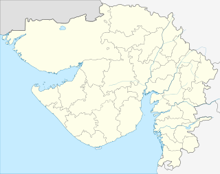
| State | Gujarat |
| District | Dang District |
| Elevation | 1,000 m (3,000 ft) |
| Population (2001) | |
| • Total | 6,301 |
| • Density | 3,151/km2 (8,160/sq mi) |
| Languages | |
| • Official | Gujarati |
| Time zone | IST (UTC+5:30) |
| PIN | 394720 |
| Telephone code | +02631 |
| Vehicle registration | GJ |
| Website | http://www.saputara.net/ |

Saputara is a hill station municipality in the Dang district of Gujarat state in India.
Geography
This hill station is on a plateau in the Dang forest area of Western Ghats (Sahyadri) range at an altitude of about 900 metres.
Saputara means the 'Abode of Serpents' and a snake image on the banks of the river Sarpaganga is worshiped by the Adivasis on Holi.
Saputara has been developed as a planned hill resort with amenities like hotels, parks, swimming pools, boat club, theaters, ropeways and a museum. It is 172 kilometres (km) from Surat and 250 km from Mumbai. The Maharashtra state border is 4 km from Saputara. Excursions from Saputara can be made to the wild life sanctuary in the Mahal Bardipara forest, 60 km. and to Gira Waterfalls 52 km away.
Sight-seeing

- Artist Village: See tribal artefacts on display. Simple accommodation is also available[1]
- Vansda National Park: Prior permission from the Chief Wildlife Warden, or Divisional Forest Officer (DFO) is needed before visiting the park
- Purna Wildlife Sanctuary: Situated at Mahal, 60 km north of Dangs
- Boating: on the Saputara Lake
- Sunrise Point: Offers the best view of Saputara and adjoining Malegoan. It is a walk of 1.5 km in the direction of Waghai. The name implies the point should only be visited at sunrise, but at any time of the day there is a panoramic view.
- Sunset Point : Has a scenic view of a of Dang Forest. The forest around Saputara is dotted with Adivasi (tribal) villages.
- The Ropeway: A ten-minute ride across the valley to Sunset Point .

- Gira Falls: Is an excursion option 52 km from Saputara. Best during the months of June to November.[2]
- Giramal Fall: Water fall in Purna wild-life century near Girmal village on Gira river.
- Shabri Dham: Shabri mata temple located near Subir village on Ahwa-Navapur road.
- Gardens
- Rose Garden, a garden with many varieties of roses.
- Step Garden, a garden set up in steps. On the steps are laid plants and flower pots
- Lake Garden, on the banks of Saputara Lake
Travel information
Saputara is 46 km from Saptashrungi (a site of Hindu pilgrimage), 172 km from Surat, 80 km from Nashik, 280 km from Mumbai, 112 km from Bilimora 420 km from Ahmedabad, 300 km from Vadodara, 589 km from Bhavnagar, 603 km from Rajkot.
- Air: Surat Airport is the nearest, 172 km away, Chhatrapati Shivaji International Airport Mumbai is the nearest international airport 360 km away.[3]
- Rail: Bilimora is the nearest railway station on Western Railways. There is a narrow gauge (0.7 m) (small train) from Bilimora to Waghai.Waghai is 52 km from Saputara .
- Road : Bus facility is available from Chikhli, Bilimora, Nasik and Surat. By bus Saputara is about three hours from Bilimora. Government buses are available from there.
Pictures
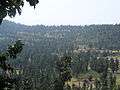 The Dang forest, en route to Saputara
 Saputara lake viewed from ropeway cab
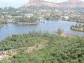 Saputara lake.
 Valley viewed from sunset point.
 A village amidst vast spans of Dang forest.
 Gira Water Fall on Waghai-Saputara road.
| Wikimedia Commons has media related to Saputara. |