Santo Antônio do Amparo
| Santo Antônio do Amparo | |
|---|---|
| Municipality | |
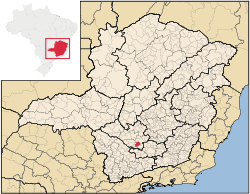 Location in Minas Gerais state | |
 Santo Antônio do Amparo Location in Brazil | |
| Coordinates: 20°56′45″S 44°55′8″W / 20.94583°S 44.91889°WCoordinates: 20°56′45″S 44°55′8″W / 20.94583°S 44.91889°W | |
| Country |
|
| Region | Southeast Region |
| State | Minas Gerais |
| Area | |
| • Total | 488.89 km2 (188.76 sq mi) |
| Population (2015) | |
| • Total | 18,367 |
| • Density | 38/km2 (97/sq mi) |
| Time zone | BRT/BRST (UTC-3/-2) |
| Postal code | 37262-xxx |
| Area code | +55-37 |
| Website |
www |
Santo Antônio do Amparo is a city in the southern part of the state of Minas Gerais, Brazil. The population is 18,367 (2015 est.) in an area of 488.89 km².[1] The municipality was founded in 1938.
Notable residents
- Hélio Garcia, former Governor of Minas Gerais, born in Santo Antônio do Amparo[2]
References
- ↑ Instituto Brasileiro de Geografia e Estatística
- ↑ "Hélio Garcia, ex-governador de Minas Gerais, morre em Belo Horizonte". G1 (website). 2014-06-06. Retrieved 2016-06-20.
External links
- http://www.citybrazil.com.br/mg/stoantonioamparo/ (in Portuguese)
This article is issued from Wikipedia - version of the 6/20/2016. The text is available under the Creative Commons Attribution/Share Alike but additional terms may apply for the media files.