Santiago Island (Galápagos)
 Santiago Island | |
| Geography | |
|---|---|
| Location | Galápagos Islands, Ecuador |
| Coordinates | 0°15′09″S 90°43′05″W / 0.252364°S 90.717952°WCoordinates: 0°15′09″S 90°43′05″W / 0.252364°S 90.717952°W |
| Archipelago | Galápagos Islands |
| Administration | |
_topographic_map-en.png)
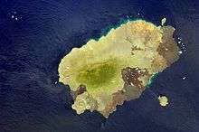
Santiago Island (Spanish pronunciation: [sanˈtjaɣo]) is an island of the Galápagos Islands. It is also known as San Salvador, named after the first island discovered by Columbus in the Caribbean Sea (see San Salvador Island), or as James Island. The island, which consists of two overlapping volcanoes, has an area of 585 square kilometers (226 sq mi) and a maximum altitude of 907 meters (2,976 ft), atop the northwestern shield volcano. The volcano in the island's southeast Marine Iguanas, sea lions, fur seals, land and sea turtles, flamingos, crabs, dolphins, and sharks are found here. There are a large number of goats and pigs, animals which were introduced by humans to the islands and have caused great harm to the endemic species. Darwin Finches and Galápagos Hawks are usually seen as well as a colony of Fur Seals. At Sullivan Bay, a recent (1897) pahoehoe lava flow can be observed.
Puerto Egas, south of James Bay and west side of Santiago, is one of the best sites. There is a long, lava shoreline where eroded rock formations house an excellent variety of wildlife. Marine iguanas bask in the sun. The tide pools contain many Sally Lightfoot crabs, which attract other types of hunters. Following the trail Fur seal lions are found. Puerto Egas is not only a good spot for taking pictures but also perfect for snorkeling and seeing many species of tropical fish.
Sullivan Bay is especially fascinating for those who are interested in geology and volcanology. You can walk over the uneroded, black lava flow covered with lava bubbles and tree-trunk molds in the surface. There are two small beaches where turtles come for nesting.
Cousin's Rock is a well-known dive site and is situated off the east coast of Santiago. It is a triangular rock that rises about 10 m (33 ft) out of the water and is made up of many layers of volcanic rock.
Sombrero Chino (Chinaman's Hat) is a small islet off the southeastern tip of Santiago. A 52-meter-high (171 ft), 0.22 km2 (0.085 sq mi) volcanic cone, it is named for its resemblance to the conical Asian hat.[1]