Santana de Parnaíba
| Santana de Parnaíba | |||
|---|---|---|---|
| Municipality | |||
|
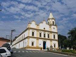
Church in Santana de Parnaíba | |||
| |||
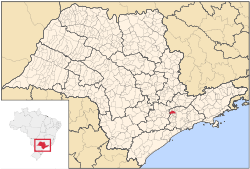 Location in São Paulo state | |||
 Santana de Parnaíba Location in Brazil | |||
| Coordinates: 23°26′38″S 46°55′4″W / 23.44389°S 46.91778°WCoordinates: 23°26′38″S 46°55′4″W / 23.44389°S 46.91778°W | |||
| Country |
| ||
| Region | Southeast Brazil | ||
| State | São Paulo | ||
| Metropolitan Region | São Paulo | ||
| Area | |||
| • Total | 179.95 km2 (69.48 sq mi) | ||
| Population (2015) | |||
| • Total | 126,574 | ||
| • Density | 700/km2 (1,800/sq mi) | ||
| Time zone | BRT (UTC-3) | ||
| • Summer (DST) | BRST (UTC-2) | ||

Santana de Parnaíba is a city and municipality in the state of São Paulo in Brazil. It is part of the Metropolitan Region of São Paulo.[1] The population is 126,574 (2015 est.) in an area of 179.95 km².[2] It was founded in 1625 near the Tietê River by Susana Dias, an important Bandeirante (Brazilian pioneers) wife.
The word Parnaíba means rocky river.
The municipality contains and administers the 367 hectares (910 acres) Tamboré Biological Reserve, a strictly protected conservation unit.[3]
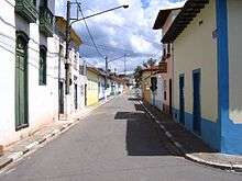
Old center of Santana de Parnaíba
References
- ↑ Lei Complementar nº 1.139, de 16 de junho de 2011
- ↑ Instituto Brasileiro de Geografia e Estatística
- ↑ O que é a Reserva? (in Portuguese), Brookfield Institute, retrieved 2016-04-19
This article is issued from Wikipedia - version of the 11/20/2016. The text is available under the Creative Commons Attribution/Share Alike but additional terms may apply for the media files.