Santa Venera
| Santa Venera Saint Venera | |||
|---|---|---|---|
| Local council | |||
|
Town hall and part of the Wignacourt Aqueduct at Santa Venera | |||
| |||
| Motto: Virtus in infirmitatate per fictur | |||
 | |||
| Coordinates: 35°53′23″N 14°28′40″E / 35.88972°N 14.47778°ECoordinates: 35°53′23″N 14°28′40″E / 35.88972°N 14.47778°E | |||
| Country |
| ||
| Region | Central Region | ||
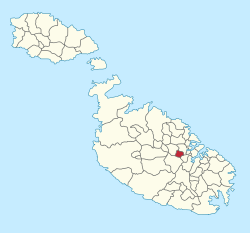
| District | Northern Harbour District | ||
| Borders | Birkirkara, Ħamrun, Msida, Qormi | ||
| Government | |||
| • Mayor | Stephen Sultana (PL) | ||
| Area | |||
| • Total | 0.9 km2 (0.3 sq mi) | ||
| Population (March 2014) | |||
| • Total | 6,932 | ||
| • Density | 7,700/km2 (20,000/sq mi) | ||
| Demonym(s) |
Vendriż (m), Vendriża (f), Vendriżi (pl) Vendrin (m), Vendrina (f), Vendrini (pl) | ||
| Time zone | CET (UTC+1) | ||
| • Summer (DST) | CEST (UTC+2) | ||
| Postal code | SVR | ||
| Dialing code | 356 | ||
| ISO 3166 code | MT-54 | ||
| Patron saint | St. Venera | ||
| Day of festa | Last Sunday of July and 14 November | ||
| Website | Official website | ||


Santa Venera is a town in the Central Region of Malta, with a population of around 6,932 (March 2014).[1] It is located between the towns of Birkirkara and Ħamrun, and it also borders Qormi and Msida.
The football team of St. Venera is the St. Venera Lightnings F.C., which bears the colours of the town: yellow and blue.
History
The first Church of St Venera was built in 1473, and it was enlarged in 1500, rebuilt between 1658 and 1688 and again in the 19th century. This church remained as the parish church until 1990. A new church was blessed in 2005.[2]
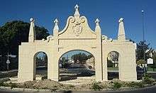
In 1610, Grandmaster Alof de Wignacourt financed the building of the Wignacourt Aqueduct to transport water from springs in Rabat and Dingli to the capital Valletta, passing through various towns along the way including Santa Venera. The Aqueduct was finished in 1615, and an ornamental gateway was built where it crossed the road between what is now Fleur-de-Lys and Santa Venera. The arches stopped at a tower known as it-Turretta (the Turret) also known as Tower Guard, also in Santa Venera. From this tower, water continued its journey to Ħamrun, Blata l-Bajda, Floriana and Valletta through underground pipes.
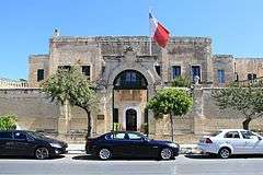
Casa Leoni, also known as Palazzo Manoel, was built around 1730 during the reign of António Manoel de Vilhena. Its design is attributed to Charles François de Mondion, the French military engineer who also designed Mdina Gate and parts of Fort Manoel. During the French blockade, Casa Leoni served as a Maltese insurgent command base, and it later served as a residence of Governors of Malta, a depository of the Museums Department and a government primary school. It now houses the Ministry for Sustainable Development, the Environment and Climate Change. The palace has a large garden behind it, part of which was opened to the public in 1977 as Romeo Romano Gardens.[3]
In the late 19th and early 20th centuries, the town of Santa Venera saw more development and various churches and institutes were built.[2] The town was considered as part of Birkirkara until 1912, and it became a separate parish six years later in 1918.
A 7 Up factory was located at Santa Venera until it was closed in 2002. The factory was demolished to make way for flats but the façades of the buildings were retained.[4]
In 1990, a large church began to be built in Santa Venera. Although it is still unfinished as the belfries have not yet been built, it was consecrated in 2005 as the new parish church.[5]
Symbols
The flag and coat of arms of Santa Venera are red with a white stripe in the middle and three red fleur-de-lys on the stripe, taken from the coat of arms of the Grandmaster Alof de Wignacourt who ruled the islands from 1601 to 1622. The flag was introduced when Malta's local councils were created in 1993. In 2013, there was a proposal for a new flag with the colours of the town blue and yellow however this was not adopted.
Education

Santa Venera has several schools:
- Saint Elias College a Catholic secondary school run by the Carmelite Friars. Its mission statement is to form a learning community where each individual is considered to be a child of God. Within a family framework, each individual has a unique value, irrespective of one's capabilities and achievements. In this manner, each individual can attain full growth through experiences which are academic, athletic, religious, creative, cultural and social.
- St Michael's College a Catholic secondary school run by the Society of Christian Doctrine (M.U.S.E.U.M.).
- Vincenzo Bugeja Conservatory
- Dun Xand Cortis
Organizations
- St. Venera Band Club (Soċjeta' Filarmonika Santa Venera V.M. 1964)
- Kummissjoni Zghazagh Palmisti Santa Venera V.M. A.D. 1994
- Kumitat Festi Esterni Parrocca Santa Venera V.M - A.D.1971
- St.Venera United Youth Football Nursery
- Ghaqda tan-Nar 26 ta' Lulju - A.D 2009
- St. Venera Lightnings Football Club
- St. Venera Scout Group
- St. Venera Girl Guides
Main roads
- Triq il-Ferrovija (Railway Road)
- Triq il-Kanun (Canon Road)
- Triq il-Kappillan Mifsud (Parish Priest Mifsud Street)
- Triq il-Kbira San Ġużepp (St Joseph High Road)
- Triq Reġjonali (Regional Road)
Zones in Santa Venera
- Tal-Palazz l-Aħmar
- Hal Kaprat
References
- ↑ "Estimated Population by Locality 31st March, 2014". Government of Malta. 16 May 2014. Archived from the original on 21 June 2015.
- 1 2 "Santa Venera". malta-canada.com. Retrieved 13 December 2014.
- ↑ "Palazzo Manoel – Casa Leoni, Sta Venera". Times of Malta. 10 November 2012. Retrieved 13 December 2014.
- ↑ "Ex 7-Up factory to become flats". Times of Malta. 23 March 2012. Retrieved 13 December 2014.
- ↑ "Archbishop inaugurates new parish church". Times of Malta. 18 July 2005. Retrieved 13 December 2014.
External links
| Wikimedia Commons has media related to Santa Venera. |
| Malta Local Councils |
| |
|---|---|---|
| Malta Administrative Committees |
| |
| Gozo Local Councils | ||
| Gozo Administrative Committees | ||