Santa Maria di Leuca
 The lighthouse of Santa Maria di Leuca | |
 Apulia | |
| Location |
Santa Maria di Leuca Apulia Italy |
|---|---|
| Coordinates | 39°47′45.4″N 18°22′06.7″E / 39.795944°N 18.368528°E |
| Year first constructed | 1866 |
| Construction | brick tower |
| Tower shape | octagonal prism tower with balcony and lantern atop a 2-storey keeper’s house |
| Markings / pattern | white tower |
| Height | 48 metres (157 ft) |
| Focal height | 102 metres (335 ft) |
| Original lens | first order Fresnel Lens (removed 1954) |
| Current lens | type OR T6 |
| Light source | mains power |
| Range |
main: 24 nautical miles (44 km; 28 mi) reserve: 10 nautical miles (19 km; 12 mi) |
| Characteristic |
Fl (3) W 15s. Oc R 4s. (to east) |
| Admiralty number | E2176 |
| NGA number | 10780 |
| ARLHS number | ITA-039 |
| Italy number | 3590 E.F. |
| Managing agent | Marina Militare[1][2] |
Santa Maria di Leuca, often spelled simply Leuca (Greek: Λευκή, from Leukos, "white"), is a frazione of the comune of Castrignano del Capo, in the province of Lecce (Apulia), southern Italy. A part of the town once belonged to the comune of Gagliano del Capo.
Description
Santa Maria di Leuca is famous for the iconic lighthouse. With its height of 47 metres, and position at 102 metres above sea level, is the second most important lighthouse in Italy, after Genova. Next to the lighthouse is the large Sanctuary, or Basilica, De Finibus Terrae ("End of the Land", 1720-1755), built to commemorate the passage of St. Peter here during his travel to Italy. It is devoted to Saint Mary (from whom the town gets the name Santa Maria di Leuca). It lies on the former site of a Roman temple dedicated to Minerva. The edifice has a fortified structure, and during its existence it sustained several assault by Algerian pirates. In the same site, a Corinthian column was erected in 1939 to celebrate the construction of the Apulian Aqueduct (Acquedotto Pugliese). The basilica is connected to the port through a 284-step staircase.

Punta Meliso promontory (the ancient Promontorium lapygium or Sallentinum) is the southeastern extremity of Italy — traditionally considered the lowest point of the geographical "heel" of Italian peninsula, as well as the meeting point of the waters from the Adriatic Sea and the Ionian Sea. But Leuca is a bay so there's another promontory called Punta Ristola challenging this geographical particularity. According to Google Earth, Punta Ristola, at 39° 47′ 22.96″ N, is approximately 440 meters south of Punta Meliso, at 39° 47′ 37.73″ N.
After World War II the town hosted Jewish Holocaust survivors for two years (1946-1948), giving them warm hospitality.
Since October 2006 its territory is part of the Regional Park "Costa Otranto - Santa Maria di Leuca e Bosco di Tricase". Santa Maria di Leuca's littoral is marked by numerous grottoes with Latin and Greek inscriptions. Also famous are the 19th century patrician villas (c. 43 in number).
Not far off Punta Ristola, at c. 85 m of depth, lies the shipwreck of the Italian submarine Pietro Micca, sunk during World War II with its crew of 58 men.
Lighthouse
Santa Maria di Leuca lighthouse is an active light located at the extremity of Capo Santa Maria di Leuca nearby the same name Sanctuary. The lighthouse was built in 1864 on project by Achille Rossi and was lit for the first time on September 6, 1866.[3] The tower, built in bricks, has an hexagonal prism shape with balcony and lantern atop a two storey keeper’s house. It has an height of 47 metres (154 ft), and is placed at 102 metres (335 ft) above sea level. The lantern has a diameter of 3 metres (9.8 ft) and emits three white flashes in a 15 seconds period visible up to 24 nautical miles while a red occulting light every 4 seconds is shown over the shoal to east.
Legend
Prehistoric remains have been found in the "Zinzolusa cave".
According to the legend, the town takes its name from "Leucasia", a white beautiful mermaid (in Greek "leukos" means "white") who conquered sailors and farmers by her charming voice. According to a later legend, Virgin Mary once saved some boats from a storm, and her name was added to that of Leuca.
Santa Maria di Leuca was founded in fact in the early 1st century AD by some monks, after Saint Peter's passage. A cross was built in his honor and after some restructurings, still be there.
See also
Gallery
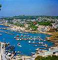 Panorama of the harbour of Leuca
 Punta Ristola
 The Sanctuary and the lighthouse
 Santa Maria di Leuca from Punta Ristola
References
- ↑ Capo Santa Maria di Leuca The Lighthouse Directory. University of North Carolina at Chapel Hill. Retrieved 5 August 2016
- ↑ Faro Capo Santa Maria di Leuca Marina Militare. Retrieved 5 August 2016
- ↑ Il faro di Santa Maria di Leuca
External links
| Wikimedia Commons has media related to Santa Maria di Leuca. |
Coordinates: 39°48′3.6″N 18°21′25″E / 39.801000°N 18.35694°E