Santa Fe, Mexico City
| Santa Fe, Mexico City | |
|---|---|
 Location in southwestern Mexico City | |
| Coordinates: 19°22′03″N 99°15′33″W / 19.367596°N 99.259275°W |


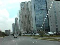
Santa Fe is one of Mexico City's major business districts, located in the west part of the city in the delegaciones (boroughs) of Cuajimalpa and Álvaro Obregón. Paseo de la Reforma and Constituyentes are the primary means of access to the district from the central part of the city. Santa Fe consists mainly of highrise buildings surrounding a large shopping mall, which is currently the largest mall in Latin America (Centro Comercial Santa Fe). The district also includes a residential area and three college campuses, among other facilities.
History

The current area of Santa Fe took its name from the nearby town of Santa Fe, the original Pueblo Hospital founded by Vasco de Quiroga in 1532.
Colonial period and independence
During the Spanish colonial era and the first century of independent Mexico, the then town of Santa Fe had an open landscape of sand mining activity, which was divided between the towns of Santa Fe, Santa Lucia, San Mateo and San Pedro Tlaltenango Cuajimalpa. Santa Fe was also connected by the former royal road connecting Tacubaya to Toluca, This royal road was located on the present day avenue called Cuajimalpa Arteaga and Salazar in the Sierra de las Cruces and continued by the current route of the federal interstate highway connecting Mexico City to Toluca.
During the Porfiriato a trolley was built on the former royal road, which at first ended at Santa Fe, and later expanded to La Venta, Cuajimalpa, and San Ángel, many trees were removed during this construction of the trolley line towards San Ángel.
1930s and 1940s
In the 1930s, the presence of sandbanks in the area caused their exploitation to fill the growing construction industry in Mexico City.
- The biggest was that the extraction of sand created a gap of almost 4 km long by 2 km wide and in some places up to 100 m depth.
- Another was the diversion of the river Tacubaya by federal highway to Toluca, leaving no water sources that could be used to supply water to the river as this feeds the area of Lomas. Natural flows and to make the drainage of the area by gravity.
- Another point was that by abrupt changes in level, the area is very limited in natural areas for building roads, as has the barrier north of the neighborhoods that were created and east and west the presence of ravines, while the national park south of the Desert of the Lions.
- Another point was that being a landfill on a hard floor, the introduction of potable water lines are in danger of contamination by leachate that can not move the site, together that the mechanical weakness of these soils makes difficult the introduction of drainage lines, and that soil settlements are in danger of breaking and increasing soil pollution, which continue to produce gas to be released every so often .
1950s
In 1953, after a derailment where several were killed in what is now the colony's Ocote Cuajimalpa, electric train service was withdrawn. the old royal road to Toluca already had by then strong competition from road federal Toluca, which runs along the west ridge which had to be stopped to avoid the collapse of the road. Today, in the south of the Calle 16 de Septiembre, one can see the outline of the path that requires them to leave the eastern ridge bordering the area and who once was a slum called Romita. This right of way gave rise to the Avenida Tamaulipas which connects with the road from Santa Lucia and the avenue Vasco de Quiroga.
1960s
In the 1960s, sand deposits became difficult to exploit because the reinforcements of the walls were increasingly difficult and costly, so the mine owners began to sell the mines to the Federal District, which the use as a landfill. Contrary to what is said, from the northern edge of Santa Fe Shopping Center to the area of the colony was used as Pena Blanca dump, even on the side of Cuajimalpa with tunnels that cross to walk of Tamarind, was a mess that was duly closed and locked when President José López Portillo built his residential complex in the popularly called "Dog Hill".
1970s
In the early 1970s, an urban development plan was created for the area, which would be built in an industrial zone in the area to provide jobs to locals and develop import substitution, between what is planned consider creating the social rehabilitation center west "Ceres" like those built in the north, south and west of Mexico City. This plan did not consider the construction of residential areas as it was anticipated the weak capacity to carry water or drainage out of the area. This even had to be ratified by the boards of neighbors from the surrounding towns.
1980s
In the 1980s, most landfills had been closed and construction of buildings had begun.
It is in 1982 that Universidad Iberoamericana was built on land donated by the Santa Fe unity government, which marks the change from industrial to residential area of great economic importance.
1990s
During the administration of President Salinas de Gortari (1988–1994), the mayor of the city, Manuel Camacho Solís, and his colleagues devised a project that in theory would be similar to the edge city of La Défense in Paris, which would be located on existing landfills. A major risk due to building on existing landfills was the spread of contaminated water that would slip into Mexico City's water supply. Modern building techniques had to be initiated to spread several flattened layers of sand over millions of tons of garbage. To safely build upon the landfill, the City created a modern Master Program which the government and investors regulate.
It is in this decade that a construction boom began with the arrival of the Santa Fe Mall. At this time and under the authority of Manuel Camacho Solís, evictions were issued to the dwellers of Romita and other neighborhoods. Most of the dwellers have resettled in the San Jose neighborhood at Cuajimalpa. Through this avenue there is access to Tamaulipas and there started the construction of the toll highway Mexico-Toluca, which was to be extended on the outskirts of the city to reach the highway to Cuernavaca.
As a result of the economic crisis in Mexico in 1994, the master plan was halted and it was not until 2000 when the first phase of Santa Fe City was reinstated. Another of Santa Fe's original projects was cancelled, the so-called "Mountain Meadows Park", as the West Alameda Park; there are three other Alameda Parks in the northern, eastern, and southern parts of Mexico City.
2000s
The inadequate road infrastructure, energy, hydro power, which was originally planned for a residential zone, and residents, generated active participation in solving their basic problems, so they propose and manage a new organization where they create a sort of government procedure in which a special item given: the GDF without telling borough governments, leading to coordination problems. For example, for drinking water can not connect to networks and to get their Cuajimalpa sewage cannot connect to networks of Álvaro Obregón and no treatment plant exists in proximity. Hence the new Government of Mexico City "GDF" has presented proposals for solution, as a road tunnel that starts from the Roma to City Santa Fe, which fail to be viable the high economic investment.
For those circumstances, in 2011, the possibility of creating a new office in the area is considered. The new borough of Mexico City was seen more as a way of validating the almost self-government in the area for the trust that manages it because the proposal covers only residential and commercial areas of high economic level, excluding the low level found on its periphery, which are part of the problem, since that is where are the roads and networks that feed the area.
Santa Fe Trust
Along with the creation of Santa Fe industrial project in the 1970s was created a trust, where the government of the then Federal District "DDF" participate with their respective offices responsible for urban development, giving investors the facilities in the area electricity, lighting, roads, water and drainage to install its industry. But with the change of plans the plans were modified the characteristics of flows and inflows, which have great impact on the area. In 1994 the Association of Settlers Zedec Santa Fe, CA with the first investors in this development, among these we have:
- Automotriz Hermer, SA of C.V.
- Banca Serfin, SA of C.V.
- Impulsora Corporate Real Estate, SA of C.V.
- Corporate Option Santa Fe II, SA of C.V.
- Universidad Iberoamericana, A.C.
- Santa Fe Park, SA of C.V.
- Property Home, SA of C.V.
- Hewlett Packard de Mexico, SA of C.V.
Residents created the Association of Settlers Zedec Santa Fe in 1999, to present a common front to the problems that were found in the area.
On February 23, 2004 under the government of Marcelo Ebrard, who had been Secretary to the Government of the DDF under the government of the regent Manuel Camacho Solis, with infrastructure problems and challenges for the Federal District to meet the objectives of the original trust was created the Trust Colon de Santa Fe, constituted by the Government of the District Federal and Settlers Association Zedec Santa Fe This is because in its origin was an urban infrastructure development, where the federal government represented by the DDF was responsible for providing urban infrastructure for industrial use, even thought to use the right of way of the old railroad to build a radio station, connecting the cities of Toluca and Mexico. Something similar to the current Tren Suburbano (suburban train) from Buenavista Station to Cuautitlán, which is partly drawn from the current highway. For this reason it has kept the local governments out of both the administration and budgets have been invested in the area by the government. Not to mention that some areas for security reasons are closed to the public way, has had to hire police corps and industrial bank, has had to provide water supply service pipes and removal by sewage pipes also.
The agreement invested amounts are a percentage of property tax and are subject to review and approval expressed by the technical committee as the highest authority of the trust and trustee, this is composed of 7 members of which 4 are appointed by the association and the 3 remaining the Federal District government and decisions are taken by majority vote and at least 1 of the GDF with the president casting vote in case of tie and extraordinarily many times as needed.
Geography
The area defined by the Federal District government as the Zona de Santa Fe is 931.64 hectares (3.5971 sq mi) in size and consists of the colonias:[1]
- Santa Fe de la Loma
- Santa Fe, Centro Ciudad
- Paseo de las Lomas
- Santa Fe Peña Blanca
- San Gabriel
- Jalalpa el Grande
- Jalalpa Tepito 2ª ampliación
- Carlos A. Madrazo
- Santa Fe Cuajimalpa
- Santa Fe Tlayacapa
Borders of the Zona de Santa Fe as described above are:[1][2][3]
- on the north: colonias Lomas de Memetla, El Yaqui, and Lomas de Vista Hermosa, then, across the Mexico-Toluca free road, the three Palo Alto colonias, behind which is col. Bosques de las Lomas including the Arcos Bosques complex.
- on the west: colonias Lomas de San Pedro, Loma del Ocote, Contadero, and Pueblo San Mateo Tlaltenango
- on the south: Ejido San Mateo, Pueblo Santa Lucía, colonias Corpus Christi, Estado de Hidalgo, Garcimarrero
- on the east: Pueblo Santa Fe, colonias Bejero del Pueblo Santa Fe, Tlapechico, and Ampliación Jalalpa
Area statistics
- Divided into 10 sectors: Downtown, Cruz Manca, La Fe, La Loma, La Mexicana, Totolapa, Paseo de las Lomas, Peña Blanca, Bosques de Santa Fe and the School Zone
- 13.80% of the total area of offices in the city
- Commercial rent between 20 and 25 dollars per square meter in a class A+ (highest-ranked) building
- 70,000 employees
- 4,311 resident families
- 8 million shopping mall visitors per year to the Centro Santa Fe
- 4 universities: Universidad Iberoamericana was the first in the zone.
- 13,500 students
Design

Academics from many universities in Mexico and abroad have studied Santa Fe's design. Some believe that the design is well-planned while others believe that the design is poor and will harm the area. Enrique Martín Moreno and María Moreno of Iberoamericana University characterize Santa Fe as a self-contained city where the inhabitants do not venture outside. Jeffrey Inaba of Harvard University argued that Santa Fe should build connections to other parts of Mexico City. Roque González, the author of the original Santa Fe development project, said in 2005 "in 15 years will be a serious problem due to the fact that there are insufficient roads, public spaces, pedestrian areas. We're headed straight into gridlock and a lack of spaces usable by humans."[4]
Economy
The airline Volaris has its headquarters in Colonia Zedec, Santa Fe, Álvaro Obregón;[5] previously they were in Peña Blanca, Santa Fe, Álvaro Obregón.[6] Grupo Bimbo has its headquarters in Peña Blanca, Santa Fe, Álvaro Obregón.[7] Chrysler Group Mexico has its head office in Santa Fe.[8] Liverpool has its headquarters in Santa Fe and in Cuajimalpa.[9]
Other companies with business offices in Santa Fe include Best Buy, Huawei, Ford, Sony, Movistar (Telefónica), Microsoft, Televisa, Roche, PepsiCo, The Coca-Cola Company, among others.
Transportation
Road access from central Mexico City remains inadequate, with Paseo de la Reforma and Avenida Constituyentes both congested at peak hours. Plans have been circulated to build a tunnel from the Circuito Interior in Condesa along Constituyentes to the point where it meets Reforma just before Santa Fe.[10]
In 2013 the Supervía Poniente opened, a toll road linking Santa Fe with the Anillo Periférico ring road at San Jerónimo in southwestern Mexico City. Just west of Santa Fe, the Chamapa-La Venta toll road connects to the Interlomas edge city and points north.
Public transportation
As far as public transportation, there are pesero minibuses and regular public buses. The Ecobus connects Santa Fe with Metro Balderas in downtown Mexico City[11] and other buses connect to Metro Tacubaya and Metro La Villa-Basílica.[12]
The area will be connected by a commuter train in 2017 on the Observatorio Toluca line.[13]
Today
Despite the criticism Santa Fe continues its development. However, the lack of infrastructure and over-investment have created an oversupply of commercial real estate. According to Colliers the vacancy rate in Santa Fe is 27 percent (2005), the highest in the city. This oversupply in the commercial real estate market can also be seen in the monthly rent, having been the highest in the city for A+ buildings it is now in the average c (range of $20–25 per square meter), Higher that of the central Paseo de la Reforma and Polanco markets.
Education
Private schools in Santa Fe and Cuajimalpa:
- Westhill Institute Santa Fe campus[14]
- Eton School elementary through high school campus[15]
- Colegio Monteverde[16][17]
- Pinecrest Institute[18] - Preschool to secundaria[19]
- Colegio Eugenio de Mazenod in Col. Prados de la Montaña is near Santa Fe.[20]
Universities in Santa Fe and Cuajimalpa
See also
Notes
- 1 2 Programa Parcial de Desarrollo Urbano de la Zona de Santa Fe (PDF) (in Spanish), Secretaría de Desarrollo Urbano y Vivienda (SEDUVI), Government of Mexico City, 2011-11-28, retrieved 2013-10-14 (Archive)
- ↑ Mapa de colonias de la Delegación Álvaro Obregón, Eldefe, retrieved 2013-10-14
- ↑ Mapa de colonias de la Delegación Cuajimalpa, Eldefe, retrieved 2013-10-14
- ↑ Grajeda, Ella. "Capital business zone in trouble." El Universal. Saturday August 6, 2005. Retrieved on February 13, 2010.
- ↑ "Information about Volaris." Volaris. Retrieved in April 9, 2016. "Antonio Dovalí Jaime, No. 70, Torre B, Piso 13, Colonia Zedec Santa Fe, Delegación Álvaro Obregón, C.P. 01210, México, Distrito Federal,"
- ↑ "Contáctanos." Volaris. Retrieved on December 4, 2010. "Dirección de oficinas Volaris - Prolongación Paseo de la Reforma 490 piso 1 Col. Santa Fe Peña Blanca México DF, Delegación Álvaro Obregón C.P. 01210"
- ↑ "Shareholder Information." Grupo Bimbo. Retrieved on November 17, 2012. "Corporative Bimbo, S.A. de C.V. Prolongación Paseo de la Reforma No. 1000 Col. Peña Blanca Santa Fe Delegación Álvaro Obregón Mexico City 01210"
- ↑ "About Us - Chrysler de Mexico." Chrysler Group. Retrieved on November 11, 2012. "Headquarters: Prol. Paseo de la Reforma 1240, Desarrollo Santa Fe, México D.F"
- ↑ "Annual Report 2013" (Archive). Liverpool. p. 28 (32/66). Retrieved on May 27, 2014. "The Company’s domicile and main place of business is: Mario Pani 200 Col. Santa Fe , Cuajimalpa México, D.F"
- ↑ CASO: TÚNEL URBANO PONIENTE: CONSTITUYENTES (PDF), BID/FOMIN/PIAPPEM, 2011-02-16, retrieved 2013-10-14
- ↑ Ruta Ecobus, RTP (Mexico City)
- ↑ Rutas de transporte pública, Universidad Iberoamericana
- ↑ http://mexiconewsdaily.com/news/train-budget-cuts-not-stopped/
- ↑ "Contact Us" (Archive). Westhill Institute. Retrieved on May 27, 2014. "Santa Fe Domingo García Ramos 56, Zona Escolar Prados de la Montaña. 05610 Mexico City"
- ↑ "Addresses & Maps." Eton School. Retrieved on May 27, 2014. "3. Elementary and Jr/Sr High School Domingo García Ramos s/n, Col. Prados de la Montaña, Santa Fe. Cuajimalpa de Morelos, C.P. 05619"
- ↑ "Información General" (Archive). Colegio Monteverde. Retrieved on May 27, 2014. "Colegio MonteVerde Av. Santa Lucía 260 Colonia Prados de la Montaña 05610 Cuajimalpa de Morelos, Distrito Federal."
- ↑ "Historia" (Archive). Colegio Monteverde. Retrieved on May 27, 2014.
- ↑ "Contacto" (Archive). Pinecrest Institute. Retrieved on May 27, 2014. "Pinecrest Institute Dirección: Francisco J. Serrano No.104 Col. Desarrollo Urbano Santa Fe, Cuajimalpa, Mexico D.F., C.P. 05348."
- ↑ "Información general" (Archive). Pinecrest Institute. Retrieved on May 27, 2014.
- ↑ "Campus Santa Fe." Colegio Eugenio de Mazenod. Retrieved on April 17, 2016. "Av. Tamaulipas 240 Col.Prados de la Montaña Del. Cuajimalpa Ciudad de México, DF 05600"
References
- Mexico City, Real Estate Market Overview 2004-2005. Colliers International.
- Ciudad de México Mercado de Oficinas 2005-2006. Colliers International.
External links
| Wikivoyage has a travel guide for Mexico City - Santa Fe. |
| Wikimedia Commons has media related to Santa Fe (Mexico City). |