Santa Clara Volcano
| Santa Clara Volcano | |
|---|---|
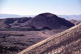 View of the southern Santa Clara cinder cone from the flanks of the northern one. | |
| Highest point | |
| Elevation | 4843+ ft (1476+ m) NAVD 88[1] |
| Coordinates | 37°15′25″N 113°37′30″W / 37.25694°N 113.62500°W |
| Geography | |
| Location |
Washington County, Utah United States |
| Geology | |
| Age of rock | 10,000 - 20,000 yrs |
| Mountain type | Volcanic field and cinder cones |
| Last eruption | Unknown |
| Climbing | |
| Easiest route | Hike |
Santa Clara Volcano is a volcanic field and lava flow in the Diamond Valley in Washington County, Utah, United States. The most prominent features are two cinder cones that rise above Snow Canyon State Park. The southern cinder cone and most of the north cinder cone are within the boundaries of Snow Canyon State Park. The city of St. George, Utah is located in the volcanic field. The date of the last eruption is unknown.
References
- ↑ "North Cinder Cone, Utah". Peakbagger.com. Retrieved 2016-04-25.
- "Santa Clara". Global Volcanism Program. Smithsonian Institution.
- Wood, Charles A.; Jürgen Kienle, eds. (1990). Volcanoes of North America. Cambridge University Press. pp. 275–6. ISBN 0-521-43811-X.
External links
![]() Media related to Santa Clara Volcano at Wikimedia Commons
Media related to Santa Clara Volcano at Wikimedia Commons
This article is issued from Wikipedia - version of the 12/2/2016. The text is available under the Creative Commons Attribution/Share Alike but additional terms may apply for the media files.