Sant Andreu
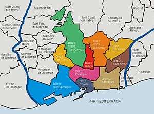
Sant Andreu (Catalan pronunciation: [ˈsant ənˈdɾew]) is one of the ten districts of Barcelona's districting in 1984. It was named after a former municipality in the plain of Barcelona called Sant Andreu de Palomar, the largest in the area, which makes up nowadays the bulk of a neighbourhood bearing the same name. A separate district, Nou Barris, includes some of the former area of Sant Andreu de Palomar.
Its size is 653 ha. (third district in size) and it had 142,598 inhabitants in 2005. It is in the northern part of the city, bordering the river Besòs, two adjacent towns in the metropolitan area, Sant Adrià de Besòs and Santa Coloma de Gramenet, and three other districts of Barcelona: Nou Barris, Horta-Guinardó and Sant Martí.
Neighborhoods
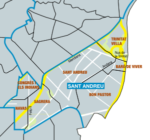
It is further divided in seven neighborhoods:[1]
- Sant Andreu de Palomar
- La Sagrera
- Trinitat Vella
- Baró de Viver
- Navas
- El Congrés i els Indians
- Bon Pastor
See also
Sources
External links
| Wikimedia Commons has media related to Sant Andreu district. |
Coordinates: 41°26′10″N 2°11′28″E / 41.43611°N 2.19111°E