Sandy Springs, Georgia
| Sandy Springs, Georgia | |
|---|---|
| City | |
| City of Sandy Springs | |
|
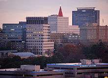
A large portion of modern Sandy Springs skyline is composed of the Concourse office towers. | |
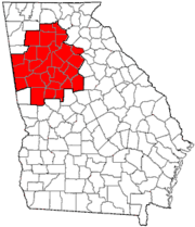
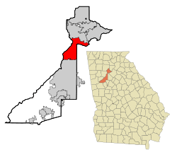 Location in Fulton County and the state of Georgia | |
 Sandy Springs Sandy Springs location in Metro Atlanta | |
| Coordinates: 33°56′15″N 84°22′7″W / 33.93750°N 84.36861°WCoordinates: 33°56′15″N 84°22′7″W / 33.93750°N 84.36861°W | |
| Country | United States |
| State | Georgia |
| County | Fulton |
| Incorporated | December 2005[1] |
| Government | |
| • Mayor | Rusty Paul[2] |
| • City Manager | John F. McDonough[3] |
| Area | |
| • Total | 38.5 sq mi (99.8 km2) |
| • Land | 37.6 sq mi (97.5 km2) |
| • Water | 0.9 sq mi (2.3 km2) |
| Elevation | 1,093 ft (333 m) |
| Population (2010) | |
| • Total | 93,853 |
| • Estimate (2014) | 101,908 |
| • Density | 2,707/sq mi (1,045.3/km2) |
| Time zone | EST (UTC-5) |
| • Summer (DST) | EDT (UTC-4) |
| ZIP codes | 30328, 30327, 30338, 30342, 30350, 30358, 30319[4] |
| Area code | 404/470/678/770 |
| FIPS code | 13-68516 |
| GNIS feature ID | 0332975[5] |
| Website |
www |

Sandy Springs is a suburban city in northern Fulton County, Georgia, United States, and part of the Atlanta metropolitan area, north of Atlanta. As of the 2010 census, Sandy Springs had a population of 93,853,[6] and as of 2014 the estimated population was 101,908.[7]
History
In 1842, the Austin-Johnson House was erected on what is now Johnson Ferry Road. It is the oldest house in Sandy Springs.[8] In 1851, Wilson Spruill donated 5 acres (2.0 ha) of land for the founding of the Sandy Springs United Methodist Church, near the natural spring for which the city is named. In 1905, the Hammond School was built at Johnson Ferry Road and Mt. Vernon Highway, across the street from the church.
In 1950, the state legislature blocked Atlanta from annexing the community, which remained rural until the Interstate Highway System was authorized by the Federal-Aid Highway Act of 1956. In 1959, after a fire at Hammond Elementary School, Atlanta Mayor William Hartsfield urged residents to support annexation so that the area would have better firefighting protection. Community opposition killed the proposal. In the early 1960s, Georgia 400 and Interstate 285 were constructed, connecting Sandy Springs to metro Atlanta and initiating a housing boom that brought new residents and major land development. In 1966, annexation by Atlanta was defeated in a referendum, with two-thirds voting against.
Debate over incorporation began in the 1970s when the city of Atlanta attempted to use a state law to force annexation of Sandy Springs. The attempt failed when the Supreme Court of Georgia ruled that the law was unconstitutional. In response, the Committee for Sandy Springs was formed in 1975. In every legislative session, state legislators representing the area introduced a bill in the Georgia General Assembly to authorize a referendum on incorporation. Legislators representing Atlanta and southwestern Fulton County, who feared tax revenue that would be lost from incorporation, blocked the bills using the procedural requirement that all local legislation be approved first by a delegation of representatives from the affected area. In 1989, a push was made for Sandy Springs to join neighboring Chattahoochee Plantation in Cobb County. This move was blocked by Speaker of the House Tom Murphy.
On January 16, 1997, Eric Rudolph bombed an abortion clinic in Sandy Springs.
When the Republican Party gained a majority in both houses of the General Assembly in 2005, the procedural rules previously used to prevent a vote by the full chamber were changed so that the bill was handled as a state bill and not as a local bill. The assembly also repealed the requirement that new cities must be at least 3 miles (4.8 km) from existing cities, because the new city limits border both Roswell and Atlanta. The bill allowing for a referendum on incorporation was introduced and passed as HB 37.[9] The referendum initiative was approved by the Assembly and signed by Governor Sonny Perdue.
The referendum was held on June 21, 2005, and residents voted 94% to 6% in favor of incorporation. Many residents expressed displeasure with county services, claiming, based upon financial information provided by the county, that the county was redistributing revenues to fund services in less financially stable areas of the county, ignoring local opposition to rezoning, and allowing excessive development. Many residents of unincorporated and less-developed south Fulton County strongly opposed incorporation, fearing the loss of tax revenues which fund county services. County residents outside Sandy Springs were not allowed to vote on the matter. Efforts such as requesting the U.S. Justice Department to reject the plan were unsuccessful.
A mayor and six city council members were elected in early November 2005, with Eva Galambos, who had initiated and led the charge for incorporation, elected mayor by a wide margin. Formal incorporation occurred on December 1, making Sandy Springs the third-largest city ever to incorporate in the U.S.[1] The city's police force and fire department began service in 2006. In 2010, the city became the first jurisdiction in Georgia to successfully "bail out" from the preclearance requirements of Section 5 of the Voting Rights Act.[10]
Geography
The boundaries of Sandy Springs are Atlanta to the south, Cobb County (at the Chattahoochee River) to the west and north, Roswell (also at the river) to the north, and Dunwoody and Brookhaven, at the DeKalb County line, to the east. A small panhandle in the northeast extends between the Chattahoochee River to the north and Dunwoody to the south, ending in a very small border with Peachtree Corners in Gwinnett County.
Climate
Sandy Springs has a humid subtropical climate (Köppen climate classification Cfa). During January and February 2014, Sandy Springs and Atlanta experienced an ice storm which gained national attention due to the huge traffic jams all over interstates such as 285, 75, and GA 400. People were forced to stay in their cars overnight in freezing temperatures.
| Climate data for Sandy Springs | |||||||||||||
|---|---|---|---|---|---|---|---|---|---|---|---|---|---|
| Month | Jan | Feb | Mar | Apr | May | Jun | Jul | Aug | Sep | Oct | Nov | Dec | Year |
| Record high °F (°C) | 75 (24) |
80 (27) |
88 (31) |
91 (33) |
95 (35) |
101 (38) |
102 (39) |
101 (38) |
98 (37) |
88 (31) |
84 (29) |
76 (24) |
102 (39) |
| Average high °F (°C) | 50 (10) |
55 (13) |
63 (17) |
71 (22) |
78 (26) |
84 (29) |
88 (31) |
86 (30) |
81 (27) |
72 (22) |
62 (17) |
53 (12) |
70.3 (21.3) |
| Average low °F (°C) | 29 (−2) |
32 (0) |
38 (3) |
45 (7) |
54 (12) |
62 (17) |
67 (19) |
66 (19) |
60 (16) |
47 (8) |
39 (4) |
32 (0) |
47.6 (8.6) |
| Record low °F (°C) | −10 (−23) |
1 (−17) |
6 (−14) |
24 (−4) |
31 (−1) |
40 (4) |
48 (9) |
50 (10) |
28 (−2) |
25 (−4) |
10 (−12) |
−1 (−18) |
−10 (−23) |
| Average precipitation inches (mm) | 5.34 (135.6) |
4.78 (121.4) |
5.52 (140.2) |
4.04 (102.6) |
4.63 (117.6) |
3.66 (93) |
4.17 (105.9) |
4.32 (109.7) |
3.87 (98.3) |
3.58 (90.9) |
3.73 (94.7) |
4.18 (106.2) |
51.82 (1,316.2) |
| Source: [11] | |||||||||||||
Neighborhoods

- Downtown: Although it does not resemble a traditional downtown, the area bounded by Abernathy Road to the north, I-285 to the south, and Sandy Springs Circle to the west, and Hildebrand Drive to the east is defined by the city and business groups as "Downtown Sandy Springs." Northside Tower, located at Roswell Road and Sandy Springs Place, has served as an unofficial landmark for the center of the district since its completion in 1971. Downtown is also the site of the actual sandy springs that spurred the name of the city. The city owns the former site of the Target store on Johnson Ferry Road at Sandy Springs Circle, with long-term plans of redeveloping the site into a mixed-use municipal complex, complete with a city hall. Also, the city is seeking to add more roads to the district so it resembles a more traditional street grid pattern.[12]
- Riverside is the western district of the city, bordering the Chattahoochee River and forming the western border with Cobb County. It is a residential area marked by winding, hilly roads. The main roads are Heards Ferry Road and Riverside Drive, and it is located off the Riverside Drive exit of I-285.[13]
- Dunwoody Panhandle: The Dunwoody Panhandle is a residential area bounded by the Dunwoody city limit to the south, the Chattahoochee River to the north, Georgia 400 to the west, and the Peachtree Corners city limit to the east. The district's name is derived from the fact that it is wedged between the river and Dunwoody, forming a geographic panhandle. Major roads include Dunwoody Club Drive and Spalding Drive, and Interstate access is through the Northridge Road exit of Georgia 400. The Dunwoody Pandhandle is a controversial area for the city, as it had been considered Dunwoody for many years. Tension mounted when Dunwoody street sign toppers were removed and replaced with Sandy Springs street sign toppers, and a street sign topper compromise proposed by the Dunwoody Homeowners Association was rejected by the Sandy Springs city council. The area also resisted being within the city limits, with residents stating that they considered themselves Dunwoody. Sandy Springs responded with a claim that the area would be marketed as "Dunwoody in Sandy Springs", much like Buckhead in Atlanta, but this has yet to be seen. Many residents still refer to their address as Dunwoody.[14]
- Perimeter Center is a commercial edge city and business district surrounding Perimeter Mall. Although about 40% of Perimeter Center, including the mall, is located in Dunwoody, the western 60%, including most of the area's office towers, are located in Sandy Springs. Pill Hill is located in the Sandy Springs section of Perimeter Center, and is the largest medical center in Georgia. It includes Northside Hospital, St. Joseph's Hospital, and Children's Healthcare of Atlanta. Landmarks include Hammond Park and the Sandy Springs and Medical Center MARTA stations.[15]
- North Springs is the large northernmost area of the city, and is generally defined as the area west of Georgia 400, east of Brandon Mill Road and the Chattahoochee River, and north of Abernathy Road. The North Springs MARTA station, the terminus of the MARTA North-South line, serves the district.[16][17][18]
- Sandy Springs ITP: A portion of Sandy Springs extends inside the Perimeter to the Atlanta city limit. Most of this area is comfortably affluent and centers around scenic, mansion-filled single-lane roads such as Northside Drive, Mt. Paran Road, Powers Ferry Road, Windsor Parkway, and Peachtree-Dunwoody Road in the Historic Brookhaven community.[19][20][21]
Demographics
| Historical population | |||
|---|---|---|---|
| Census | Pop. | %± | |
| 1980 | 46,877 | — | |
| 1990 | 67,842 | 44.7% | |
| 2000 | 85,781 | 26.4% | |
| 2010 | 93,853 | 9.4% | |
| Est. 2015 | 105,330 | [22] | 12.2% |
| U.S. Decennial Census[23][24] 2012 Estimate[25] | |||
(Note: the 2000 census numbers are for Sandy Springs prior to incorporation, but cover the same area.)
According to the 2010 census the population of Sandy Springs was 93,853. There were 42,334 households. The racial and ethnic composition of the population was 65.0% white, 20.0% black or African American, 0.3% Native American, 5.0% Asian, 6.9% from some other race and 2.7% from two or more races. 14.2% of the population was Hispanic or Latino of any race.[26]
In the official census of 2000, when there were 85,781 people, 39,288 households, and 19,683 families residing in the CDP, the population density was 2,274.1 people per square mile (878.1/km²). There were 42,794 housing units at an average density of 1,134.5 per square mile (438.0/km²). The racial makeup of the CDP was 77.55% White, 12.04% African American, 0.18% Native American, 3.29% Asian, 0.05% Pacific Islander, 4.94% from other races, and 1.95% from two or more races. Hispanic or Latino of any race were 9.93% of the population. According to a 2006 report by the Atlanta Jewish Federation, 15,300 Jews reside in Sandy Springs and the adjacent city of Dunwoody.[27]
There were 48,288 households, out of which 21.1% had children under the age of 18 living with them, 40.1% were married couples living together, 7.0% had a female householder with no husband present, and 49.9% were non-families. 35.9% of all households were made up of individuals and 6.8% had someone living alone who was 65 years of age or older. The average household size was 2.17 and the average family size was 2.87.
In the CDP the age distribution of the population shows 17.8% under the age of 18, 10.5% from 18 to 24, 40.3% from 25 to 44, 21.6% from 45 to 64, and 9.8% who were 65 years of age or older. The median age was 33 years. For every 100 females there were 96.6 males. For every 100 females age 18 and over, there were 95.0 males.
According to a 2008 estimate, the median income for a household in the city was $106,240, and the median income for a family was $129,810. The average income for a household was $116,406 and the average income for a family was $169,815. Males had a median income of $60,053 versus $50,030 for females. The per capita income for the city was $70,790. About 3.1% of families and 7.9% of the population were below the poverty line, including 8.9% of those under age 18 and 1.9% of those age 65 or over.[28][29]
Arts and culture
Annual festivals
Sandy Springs offers a host of annual events each year.
The Sandy Springs Festival is the largest community event in Sandy Springs, with approximately 30,000 attendees. Established in 1984, the annual festival celebrated its 30th year in 2015. The festival features a juried artist's market, civic and business expo, performances by regional acts and community bands, a children's area with crafts and activities, a teen territory with bungee jumps and inflatables, the annual Kiwanis Pet Parade, the annual Doug Kessler Lighting 10K/5K race, and a food court. The festival serves as the primary fundraiser for Heritage Sandy Springs, a nonprofit dedicated to building community through preserving and promoting the historic and cultural identity of Sandy Springs. Heritage Sandy Springs also maintains Heritage Green, a 4-acre (1.6 ha) park in the heart of Sandy Springs. The most recent festival was held September 19–20, 2015.[30]
Sandy Springs Artapalooza is a free fine arts festival held each year in Sandy Springs. Each year 125 to 150 notable artists from across the country have the opportunity to participate. Organizers of the event include the Georgia Foundation for Public Spaces and ArtsSpring, two groups that are dedicated to bringing free arts programs to the community.[31]
Stars and Stripes Celebration is an annual community fireworks display held over the July 4th holiday at the Concourse Corporate Center. The community gathers on the Concourse lawn for fireworks and live music.[32]
The annual Chattahoochee River Summer Splash, held in July, is a 6-mile (10 km) float along the Chattahoochee River, beginning at Morgan Falls Dam and finishing at Cochran Shoals-Powers Island National Recreation Area. After completing the float, participants can enjoy an afternoon of live music, food and fun during festivities at Powers Island. Guests can bring their own kayaks, canoes, or rafts, or rent them from several local outfitters.
Points of interest
The Heritage Sandy Springs Museum opened on March 20, 2010. It is dedicated to the history of the Sandy Springs community and is located in the repurposed Williams-Payne house at Heritage Green. Two notable exhibits are "Sandy Springs: Land and People", which tells the changing story of Sandy Springs as the home of Native Americans, rural farmers, and modern suburbanites; and "A Land Nearby", which features a collection of 20 photographs of Georgia's Barrier Island taken by Dr. Curt Hames Jr.
Sandy Springs also has a museum devoted to Anne Frank.
Parks


Sandy Springs' sixteen parks and greenspaces offer more than 950 acres (380 ha) of parkland.[33]
- Heritage Green - a 4-acre (1.6 ha) park at the center of Sandy Springs' new downtown development. It is the site of the original underground springs for which the city is named and is anchored by the Heritage Sandy Springs Museum. It is operated and managed by Heritage Sandy Springs, a 501(c)3 nonprofit organization dedicated to building community through preserving and promoting the historic and cultural identity of Sandy Springs. Heritage Sandy Springs presents a full calendar of public programs and events, including the Sandy Springs Festival, museum exhibits, lectures and programs, three concert series, children's educational and enrichment programming, and community gardening programs.
- Hammond Park - multipurpose building, gym, game room, AstroTurf soccer field, lighted tennis courts, basketball courts, picnic pavilions, playground, restrooms
- Morgan Falls Overlook - picnic pavilions, children's playground, boat dock/fishing pier, hiking trail, fire pit, porch swings, scenic views, restrooms
- Morgan Falls Athletic Complex - baseball and softball fields, football fields, picnic pavilions, playgrounds, concessions stand, restrooms
- Sandy Springs Tennis Center - Clubhouse, pro shop, restrooms, locker rooms, lighted tennis courts, jogging trail
- Abernathy Park - Tennis courts, playground, picnic tables, arts center
- Allen - playground, multipurpose court, walking trail, basketball court
- John Ripley Forbes Big Trees Forest Nature - trails, tree, plant and wildlife sanctuary[34]
- Ridgeview - nature trails, picnic pavilion, playground
- Abernathy Greenway - currently the city's newest park; a linear park opened in 2014; features playable art sculptures
Government
Officials
- Mayor: Rusty Paul
- District 1: John Paulson
- District 2: Ken Dishman
- District 3: Chris Burnett
- District 4: Gabriel Sterling
- District 5: Tiberio "Tibby" DeJulio
- District 6: Andy Bauman
- City Manager: John McDonough
Services
Sandy Springs is notable for contracting private companies to perform the majority of its services in a public-private partnership model of government. While many governments contract with private-sector companies on a per-project basis, Sandy Springs is believed to be the first American city to outsource its services for the majority of ongoing operations, and the city regularly hosts delegations from other governments that are interested in the model.[35] Services not outsourced include police, fire-rescue and city management.
The city's police department took over services from Fulton County on July 1, 2006, with 86 police officers from all over the state of Georgia, and is now staffed by 137 officers. The city's fire department began operations in December 2006. The department consists of 97 full-time firefighters. The former police chief, Gene Wilson Jr., was replaced by Terry Sult in 2008 - 2013. The fire department was headed by Chief Jack McElfish from 2005 - 2014. Kenneth DeSimone is the current chief of police, while the fire department is headed by Chief Keith Sanders. It is staffed by 91 full-time firefighters and 52 part-time firefighters. The police department answered 98,250 calls in FY 2010, while the fire department handled 17,000 responses to 8,205 calls for service.
The city of Sandy Springs has purchased the old Target Corporation building (originally Richway) located on the corner of Sandy Springs Circle and Johnson Ferry Road.[36] The building has sat vacant since the December 2008 purchase. This location will one day be the new home to the Sandy Springs City Hall.[37]
Education
Primary and secondary schools
Public schools are operated by the Fulton County School System. Elementary schools serving sections of Sandy Springs include Dunwoody Springs Charter Elementary School, Heards Ferry Elementary School, High Point Elementary School, Ison Springs Elementary School, Lake Forest Elementary School, Spalding Drive Charter Elementary School, and Woodland Charter Elementary School.[38] Two middle schools, Sandy Springs Middle School and Ridgeview Charter Middle School, and two high schools, North Springs Charter School of Arts and Sciences and Riverwood High School, are in and serve Sandy Springs.
Private schools located in Sandy Springs include:
- Brandon Hall School (5th grade through high school)
- Springmont (formerly First Montessori School of Atlanta) (preschool through middle school)
- Atlanta Jewish Academy (k–12)
- Holy Innocents' Episcopal School (preschool through high school)
- Mount Vernon Presbyterian School (preschool through high school)
- St. Jude the Apostle Catholic School (k–8)
- The Alfred and Adele Davis Academy (k–8)
- The Felicia Penzell Weber Jewish Community High School (high school) – rated Top High School by the Sandy Springs School Association in 2009
- The Epstein School (k–8)
- Holy Spirit Preparatory School (k–12)
- Cumberland Academy
Public libraries
Atlanta-Fulton Public Library System operates the Sandy Springs Branch.[39]
Economy
The largest employers within Sandy Springs are hospitals, headquarters and regional offices from a variety of industries including computer related services, package delivery, telecommunications, media, and financial transaction processing.
Sandy Springs is home to three hospitals: Northside Hospital, St. Joseph's Hospital and Children's Healthcare of Atlanta, comprising 40 percent of the hospital beds in the region.
Top employers
According to the city's 2014 Comprehensive Annual Financial Report,[40] the top employers in the city are:
| # | Employer | # of employees |
|---|---|---|
| 1 | IBM | 3,396 |
| 2 | Cox Enterprises | 2,005 |
| 3 | Cisco Systems, Inc. | 1,690 |
| 4 | United Parcel Service | 1678 |
| 5 | VMware | 1400 |
| 6 | Manheim Auctions | 1140 |
| 7 | Oracle | 1062 |
| 8 | AT&T Mobility | 789 |
| 9 | National Account Service Co | 688 |
| 10 | Walden Security | 650 |
Media
Some notable newspapers that cover areas of interest to Sandy Springs include the andy Springs Reporter,[41] Sandy Springs Neighbor[42] and The Atlanta Journal Constitution.[43] Two television series are recorded within the city: Auction Kings at Gallery 63 on Roswell Road, and Say Yes to the Dress: Atlanta at Bridals by Lori on Hammond Drive. The Vampire Diaries series also regularly films scenes at Glenridge Hall, which is portrayed as the main characters' home.
Infrastructure
Roads
Sandy Springs is served by two major limited-access highways, Georgia 400 − which runs north-south − and I-285 − which runs east-west. Major surface streets include Roswell Road (U.S. 19 south of I-285 and Georgia 9 entirely), Hammond Drive, Spalding Drive, Johnson Ferry Road, Abernathy Road, Glenridge Drive, and Dunwoody Club Drive.
Recently completed major road projects include the widening of Abernathy Road between Johnson Ferry and Roswell Roads from two lanes to four plus a road median. The western intersection has been reconfigured so that traffic to and from Johnson Ferry Road − which carries heavy loads of Cobb County commuters across the Chattahoochee River at rush hour − now flows directly with Abernathy to and from the northwest. Additionally, the Roswell Road bridge over I-285 has been widened to add a turn lane in each direction. There had previously been talk of a tunnel under the freeway to bypass the highway interchange altogether, however this proved to be much too expensive. Another state project is the addition of a half-diamond interchange to Georgia 400 on the north side of Hammond Drive, allowing southbound traffic to exit and northbound traffic to enter the highway. (Ramps on the south side were not possible due to the proximity of the 400/285 interchange.)
The city's public works department has made significant improvements in the conditions of roads and traffic signals since incorporation in December 2005. The department has cleaned approximately 1,500 catch basins, striped 30 miles (48 km) of roadway, responded to more than 2,000 calls for repair and service, re-timed hundreds of traffic lights to help improve the flow of traffic and reduce automobile idling, and repaved 60 miles (nearly 100 km) of roads.
The 2008 fiscal year saw the creation of the Sandy Springs Traffic Management Center (TMC). The TMC was constructed and began to operate in less than six months. Construction began in February 2008, five cameras viewed traffic along Roswell Road by the end of June. Special features of the TMC include a webpage that allows the public access to real-time traffic conditions and voice-activated controls. By June 2009, 16 traffic cameras are now available and can be viewed online at the city's website.[44]
Transit systems
The major provider of mass transit is MARTA, which operates a heavy rail rapid transit line and several bus lines through Sandy Springs. The city is served by the Medical Center, Sandy Springs and North Springs stations. The Georgia Regional Transportation Authority also operates express buses from the North Springs station (which has its own ramps to and from 400) to other counties.
Diplomatic missions
The city has three consulates general.[45] The Consulate-General of Colombia in Atlanta is located in Suite 405 at 5901 B Peachtree Dunwoody Road.[46] The Consulate-General of Nigeria in Atlanta[47] is located at 8060 Roswell Road.[48] The Counsulate-General of India is at 5549 Glenridge Drive.
Notable people
- Harris Barton, former NFL offensive lineman
- Mike Bettes, meteorologist at The Weather Channel
- Todd English, celebrity chef
- Julius Erving, NBA player
- Eva Galambos, first mayor of Sandy Springs
- David Justice, former Atlanta Braves baseball player
- Simon Kornblit, studio executive, actor
- Hines Ward, retired Pittsburgh Steelers wide receiver
References
- 1 2 Daughters of the American Revolution, Sandy Springs Chapter (2010). "City of Sandy Springs - From the Daughters of the American Revolution, Sandy Springs Chapter". City of Sandy Springs. Retrieved 2010-07-27.
- ↑ City of Sandy Springs (2010). "City of Sandy Springs - Mayor's Office". Retrieved 2010-07-27.
- ↑ City of Sandy Springs (2010). "City of Sandy Springs - City Manager's Office". Retrieved 2010-07-27.
- ↑ United States Postal Service (2012). "USPS - Look Up a ZIP Code". Retrieved 2012-02-15.
- ↑ "US Board on Geographic Names". United States Geological Survey. 2007-10-25. Retrieved 2008-01-31.
- ↑ "Geographic Identifiers: 2010 Census Summary File 1 (G001), Sandy Springs city, Georgia". American FactFinder. U.S. Census Bureau. Retrieved May 2, 2016.
- ↑ "Annual Estimates of the Resident Population for Incorporated Places: April 1, 2010 to July 1, 2014". Retrieved June 4, 2015.
- ↑ SandySprings.com (2009). "Sandy Springs GA History". Retrieved 2010-07-27.
- ↑ Wilkinson, Joe; Willard, Wendell; Geisinger, Harry; Lindsey, Edward (2005). "Georgia General Assembly - House Bill 37". Georgia General Assembly. Retrieved 2010-07-27.
- ↑ "U.S. Reaches Agreements with Kings Mountain, N.C., and Sandy Springs, Ga., to Terminate Coverage from Preclearance of the Voting Rights Act". Justice.gov. 2010-09-22. Retrieved 2012-12-18.
- ↑ "Average weather for Sandy Springs". Weather.com. Retrieved 13 August 2009.
- ↑ "'Downtown' Sandy Springs: What can bring the core together?". 2010-06-18. Retrieved 2012-12-18.
- ↑ Archived August 26, 2010, at the Wayback Machine.
- ↑ December 18, 2012 (2006-07-25). "Sandy Springs vetoes Dunwoody toppers - Dunwoody Crier: Local News". Thecrier.net. Retrieved 2012-12-18.
- ↑ "About Perimeter CIDs - Perimeter Community Improvement Districts".
- ↑ "MARTA - Metropolitan Atlanta Rapid Transit Authority". Itsmarta.com. Retrieved 2012-12-18.
- ↑ "www.northspringshigh.com".
- ↑ Archived August 22, 2011, at the Wayback Machine.
- ↑ "Sandy Springs ITP". intowninsider.com. Retrieved 2012-12-18.
- ↑ http://www.5265longisland.com/index.php?option=com_content&view=article&id=82&Itemid=114
- ↑ "Startups, Entrepreneurs and Innovation - Upstart Business Journal" (PDF). Portfolio.com. Retrieved 2012-12-18.
- ↑ "Annual Estimates of the Resident Population for Incorporated Places: April 1, 2010 to July 1, 2015". Retrieved July 2, 2016.
- ↑ United States Census Bureau. "Census of Population and Housing". Retrieved August 20, 2013.
- ↑ Census numbers enumerated were for "Sandy Springs CDP"
- ↑ "Annual Estimates of the Resident Population: April 1, 2010 to July 1, 2012". Retrieved August 20, 2013.
- ↑ 2010 profile of general population and housing characteristics of Sandy Springs from the US Census
- ↑ "Highlights of Jewish Community Centennial Study 2006". Shalomatlanta.org. Retrieved 2012-12-18.
- ↑ Sandy Springs 2007 Income Estimates
- ↑ "Sandy Springs, GA".
- ↑ "Sandy Springs Festival".
- ↑ "Sandy Springs Artsapalooza". Sandy Springs Artsapalooza.
- ↑ "Sandy Springs, GA".
- ↑ "Sandy Springs, GA".
- ↑ Hurd, Hatcher (August 1, 2012). "John Ripley Forbes, the great man nobody knows: Left indelible (green) mark on North Fulton, Atlanta". Alpharetta and Roswell Revue & News. Appen Newspapers Inc. Retrieved 2014-04-01.
- ↑ David Segal (June 23, 2012). "A Georgia Town Takes the People's Business Private". New York Times.
- ↑ "Sandy Springs to purchase former Target site | Sandy Springs Homes for Sale - Sandy Springs Real Estate - Restaurants - Businesses - Events". 2008-12-11. Retrieved 2012-12-18.
- ↑ http://sandyspringscitycenter.com/ Sandy Springs City Center Redevelopment Website
- ↑ "Sandy Springs Elementary School Attendance Boundaries School Year 2009–2010." Fulton County School System. Accessed October 26, 2008.
- ↑ "Sandy Springs Branch." Atlanta-Fulton Public Library System. Retrieved on February 24, 2010.
- ↑ "City of Sandy Springs, GA CAFR". sandyspringsga.org. Retrieved 2015-04-13.
- ↑ Sandy Springs Reporter
- ↑ Marietta Daily Journal - Neighbor Newspapers. "Northside / Sandy Springs". Marietta Daily Journal - Neighbor Newspapers.
- ↑ "AJC.com: Atlanta News, Sports, Atlanta Weather, Business News".
- ↑ Capital Improvement Projects
- ↑ "Consulates." Georgia Department of Economic Development. Accessed October 26, 2008.
- ↑ Home page. Consulate-General of Colombia in Atlanta. Accessed October 26, 2008.
- ↑ " Consulate-General of Nigeria in Atlanta. Accessed November 10, 2008
- ↑ Consulate Location
External links
| Wikivoyage has a travel guide for Sandy Springs. |
- City of Sandy Springs official website
- Sandy Springs Hospitality and Tourism
- Sandy Springs community site
- Heritage Sandy Springs
- The City of Sandy Springs, Georgia historical marker
- The History of the City of Sandy Springs, Georgia historical marker
- The Sandy Springs historical marker
- Sandy Springs UMC Cemetery historical marker
Municipalities and communities of Fulton County, Georgia, United States | ||
|---|---|---|
| Cities | 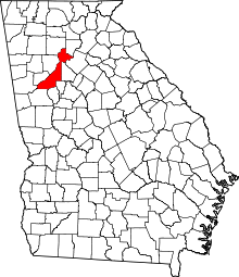 | |
| Unincorporated communities | ||
| Footnotes | ‡This populated place also has portions in an adjacent county or counties | |
|  | |||||||
|
| ||||||||
| ||||||||
Template:Georgia