Sandy Bay, Saskatchewan

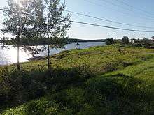
Sandy Bay is a northern village in Saskatchewan, Canada.[1] It is located 190 km northwest of Creighton via the Hanson Lake Road and Highway 135. The community is on the banks of the Churchill River. It is at the end of Highway 135, after passing through Pelican Narrows. Sandy Bay is 72 km north of Pelican Narrows. Pelican Narrows, the neighbouring community, is the administrative centre for the Peter Ballantyne Cree Nation and the majority of the townsite is reserve land. Sandy Bay is split into two parts: the northern village part and the north part, which is reserve (Wapaskokimaw Reserve #202).
Sandy Bay is situated at "road's end" in the northeast area of north eastern Saskatchewan and occupies land that was home to Aboriginal peoples for hundreds of years before it became the site of power generation from the Churchill River for mineral exploration and extraction.
It is close to the Manitoba border, and its economic and social ties to that province are extensive.
Sandy Bay is administered by the Northern Village of Sandy Bay. The community has a health clinic, a rehabilitation centre, a recreation board and a K-12 school. SaskTel put a communications tower in Sandy Bay in 2008 and the community has cellular service including, as of 2011, a 3G network. Sandy Bay has a population of about 1,200, of whom about one quarter are members of the Peter Ballantyne Cree Nation.
History
Sandy Bay grew around the hydroelectric power station built in the late 1920s to supply power for the smelters and mines in Flin Flon, Manitoba. It was initially situated further downstream on the Churchill River, but the residents were encouraged to relocate near the proposed site of the Island Falls Generating Station to provide a source of labour for its construction. The community then grew as the Island Falls Generating Station altered traditional lifestyles. In 1965 Sandy Bay became a Local Community Authority. In 1966 the Island Falls Generating Station switched to an automatic system and the majority of jobs were lost. An all-weather road was built into the community in 1967 and other services followed. In the 1980s Sandy Bay was designated as a northern village.
The dam is presently operated by SaskPower and is now totally automated. Tourism is now the major industry in the area. There is a local store in the community, but other supplies and groceries can be purchased in Flin Flon, Manitoba, two hours away on gravel and paved highways.
The reason the people actually moved from their old site to the new one was that the building of the dam flooded out the old townsite, so the people had to move to the new one. The new site was basically shacks and very little else for many decades, people lived in poverty having to draw water from the Bay, water that was increasingly poisoned from the pollution of the Hydro Electric Dam. One of the main staples of the diet of the people of Sandy Bay was the abundant Sturgeon, which after the building of the dam, dwindled away to near nothing.<citation needed>
The community that grew up beside the dam flourished though, having a running water, electricity and every amenity they could possibly want, including stores to shop in, by comparison, the people in Sandy Bay, when they made use of these amenities, were forced to do it at shoulders length. That is, they had to be invited, and when the people shopped at the same store, they were forced to stand in line, and hand a list to the clerks through a portal, then the clerks would fill the lists for them. This was life from the building of that community to the 1970s for everyone in Sandy Bay, until the new mayor, a priest, had a hand in building the road that gave the people in Sandy Bay access to Creighton, Flin Flon and Prince Albert, where they could travel to (sometimes 200 or more miles) to shop.
The people in Sandy Bay did not get electricity until the 1970s, and running water came slowly in stages. The road that connected the community to other places came at about this same time.
Demographics
| Canada census – Sandy Bay, Saskatchewan community profile | |||
|---|---|---|---|
| 2011 | 2006 | 2001 | |
| Population: | 1,233 (+4.9% from 2006) | 1,175 (+7.6% from 2001) | 1,092 (+13.8% from 1996) |
| Land area: | 14.85 km2 (5.73 sq mi) | 14.85 km2 (5.73 sq mi) | 14.85 km2 (5.73 sq mi) |
| Population density: | 83.0/km2 (215/sq mi) | 79.1/km2 (205/sq mi) | 73.5/km2 (190/sq mi) |
| Median age: | 17.4 (M: 15.9, F: 18.7) | 17.4 (M: 15.9, F: 18.7) | 18.5 (M: 18.6, F: 18.5) |
| Total private dwellings: | 256 | 240 | 249 |
| Median household income: | $20,512 (Single Parent) | $20,512 (Single Parent) | $19,392 (Single Parent) |
| References: 2011[2] 2006[3] 2001[4] | |||
Climate
| Sandy Bay (Island Falls Station) | ||||||||||||||||||||||||||||||||||||||||||||||||||||||||||||
|---|---|---|---|---|---|---|---|---|---|---|---|---|---|---|---|---|---|---|---|---|---|---|---|---|---|---|---|---|---|---|---|---|---|---|---|---|---|---|---|---|---|---|---|---|---|---|---|---|---|---|---|---|---|---|---|---|---|---|---|---|
| Climate chart (explanation) | ||||||||||||||||||||||||||||||||||||||||||||||||||||||||||||
| ||||||||||||||||||||||||||||||||||||||||||||||||||||||||||||
| ||||||||||||||||||||||||||||||||||||||||||||||||||||||||||||
Sandy Bay has warm summers and cold winters. The average daytime high does not exceed 25 °C, but it is common to have heat waves where the temperature will reach 30 °C to 35 °C. In the winter the average daytime low does not dipp below - 25 °C, but is it common to get cold fronts that bring the air temperature to -40 °C. Add in the windchill and the temperature can feel like -50 °C.
The majority of the precipitation occurs during the summer months, mainly June and July. The average annual precipitation is 460mm. During the summer months it is common for the rain to fall in large amounts during short periods of time. Lightning and Thunder Storms are almost a daily occurrence in the summer evenings. With heavy amounts of rain, the lakes, rivers and streams fill up fast and can cause problems.
In the summer of 2011 the Sandy Bay and Pelican Narrows region received a large amount of rain over a three-day period. The rivers overflowed and the main road was washed out in several places. The roads were impassable. The communities were cut off from regular services and no one could leave. The Hansen Lake Road, Highway 106, was washed out and became impassable. The provincial Ministry of Transportation worked around the clock to fix the roads and had them open within a few days.
The hottest day on record was on July 21, 1929 when the daytime high reached 40 °C. The coldest day on record was on January 15, 1930 when the daytime low reached -46.1 °C and that does not include the windchill. The most amount of rain, in a single day, was on August 22, 1936 when 77mm of rain fell. The day with the most amount of snow was on November 28, 1973 when 28 cm of snow fell.
Hector Thiboutot School
The Hector Thiboutot Community School offers schooling for children from Kindergarten to Grade 12. The school has over 500 students. Like most schools in the division, it has a large gymnasium, science lab, home economics room, industrial arts shop, community library, computer room and many large classrooms. Furnished rental teacherages are provided for the staff. The school offers exciting and challenging programs for the students.
Sandy Bay Memorial Beach
The Sandy Bay Memorial Beach is a community based project in memory of the children who have drowned in the Churchill River. In the summer of 2011 the community came together and decided to build a safe recreational area where the children can swim. The beach provides a controlled swimming environment and some of the safety features are floating docks, buoys, and an emergency access ramp which are not common in Aboriginal Northern communities. The community is planning on having lifeguards working in the summer months and it will be the perfect spot for the whole family to swim. This project has created new jobs for the community and gives youth work experience. The Hector Thiboutot School joined the project to teach the students about water safety and about playing near frozen rivers/lakes in the winter.
Notable buildings (services)
- Hector Thiboutot School (K-12)
- Garry MORIN Memorial Hall (Community Center and hosts Court every two weeks)
- Sandy Bay General Store (Opened in January 2011 - Has produce, frozen items, dairy, baked goods, and general grocery items)
- Sandy Bay Gas Bar
- Sandy Bay Community Resource Center (CRC)
- Restaurant / Convenience Store
- Sandy Bay Airport is located 4 km Northeast of Sandy Bay
- Catholic Church
- The Northern Village Office (Canada Post - Mail Arrives Monday, Wednesday and Friday)
- The Band Office
- Pre-School
- Daycare
- Sandy Bay Health Center (Nursing Station - Doctors fly in twice a week)
- Fire Hall (Volunteer Crew)
- Police Detachment (Royal Canadian Mounted Police)
Events
- Treaty Days
- Annual Fish Derbies (Summer)
- Annual Ice Fishing Derbies (Winter)
- Powwows
- Sweat Lodge
- Sundance Festival
- Elder Talks
- Cultural Events
- hanging out with friends
Recreation
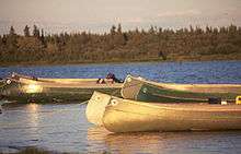
- Hunting
- Fishing
- Ice Fishing
- Swimming
- Hiking
- Snowmobiling
- ATV (Quads)
- Ice Hockey (In winter on the Churchill River)
- Boating
- Canoe/Kayaking
- Cross Country Skiing
Distance from

- Creighton, SK 188 km
- Deschambault Lake, SK 189 km
- Prince Albert, SK 457 km
- La Ronge, SK 372 km
- Saskatoon, SK 598 km
- Regina, SK 754 km
- The Pas, MB 334 km
- Winnipeg, MB 962 km
- Brandon, MB 882 km
- Edmonton, AB 1047 km
- Calgary, AB 1205 km
- Toronto, ON 3016 km
- Vancouver, BC 2199 km
References
- ↑ "Search for Municipal Information". Government of Saskatchewan. Retrieved April 7, 2014.
- ↑ "2011 Community Profiles". Canada 2011 Census. Statistics Canada. July 5, 2013. Retrieved 2012-03-08.
- ↑ "2006 Community Profiles". Canada 2006 Census. Statistics Canada. March 30, 2011. Retrieved 2011-07-06.
- ↑ "2001 Community Profiles". Canada 2001 Census. Statistics Canada. February 17, 2012. Retrieved 2011-07-06.
External links
- Peter Ballantyne Cree Nation Sandy Bay Profile
- Island Falls Profile
- The Weather Network
- Northern Saskatchewan Heritage Site
Coordinates: 55°31′50″N 102°18′56″W / 55.53056°N 102.31556°W