Sandøy
| Sandøy kommune | |||
|---|---|---|---|
| Municipality | |||
 | |||
| |||
 Sandøy within Møre og Romsdal | |||
| Coordinates: 62°45′40″N 6°27′5″E / 62.76111°N 6.45139°ECoordinates: 62°45′40″N 6°27′5″E / 62.76111°N 6.45139°E | |||
| Country | Norway | ||
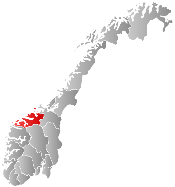
| County | Møre og Romsdal | ||
| District | Romsdal | ||
| Administrative centre | Steinshamn | ||
| Government | |||
| • Mayor (2011) | Hans Endre Sæterøy (H) | ||
| Area | |||
| • Total | 20.42 km2 (7.88 sq mi) | ||
| • Land | 20.35 km2 (7.86 sq mi) | ||
| • Water | 0.07 km2 (0.03 sq mi) | ||
| Area rank | 427 in Norway | ||
| Population (2013) | |||
| • Total | 1,291 | ||
| • Rank | 388 in Norway | ||
| • Density | 63.4/km2 (164/sq mi) | ||
| • Change (10 years) | -0.003 % | ||
| Demonym(s) | Sandøying[1] | ||
| Time zone | CET (UTC+1) | ||
| • Summer (DST) | CEST (UTC+2) | ||
| ISO 3166 code | NO-1546 | ||
| Official language form | Nynorsk | ||
| Website |
www | ||
|
| |||

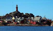
Sandøy is an island municipality in Møre og Romsdal county, Norway. It is part of the Romsdal region. The administrative centre is the village of Steinshamn. Other villages include Ona and Myklebost. The municipality is spread out over many islands in the mouth of the Romsdalsfjorden. The Flatflesa Lighthouse and Ona Lighthouse protect the boats traveling around the municipality.
General information

The municipality of Sandø i Romsdal was established on 1 January 1867 when it was separated from Akerø Municipality. The initial population was 601. The spelling of the name was later changed to Sandøy. On 1 January 1965, the Myklebost area on Harøya island and some smaller islands to the west (population: 287) were transferred from Haram Municipality to Sandøy Municipality.[2]
Name
The municipality (originally the parish) is named after the farm and the small island, Sandøya (Old Norse: Sandøy), since the first church (Sandøy Church) was built there. The first element is sandr which means "sand" and the last element is øy which means "island". The name was historically spelled Sandø or Sandøen.[3]
Coat-of-arms
The coat-of-arms is from modern times. They were granted on 12 December 1986. The arms show the light beams from the Ona Lighthouse, since lighthouses play an important role in the safety in the municipality, which consists of 871 islands and skerries.[4]
Churches
The Church of Norway has one parish (sokn) within the municipality of Sandøy. It is part of the Molde arch-deanery in the Diocese of Møre.
| Parish (Sokn) | Church Name | Location of the Church | Year Built |
|---|---|---|---|
| Sandøy | Sandøy Church | Sandøya | 1812 |
| Harøy Church | Harøya | 1934 |
Geography
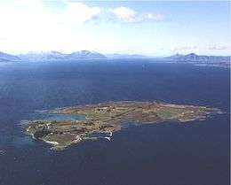
Sandøy is an island municipality. Sandøy consists of 871 islands, but only five are regularly inhabited. The main inhabited islands are Harøya, Sandøya, Finnøya, Ona, and Orta. Ona is the most famous of the islands and is a popular tourist destination due to its history and the Ona Lighthouse.
References
- ↑ "Navn på steder og personer: Innbyggjarnamn" (in Norwegian). Språkrådet. Retrieved 2015-12-01.
- ↑ Jukvam, Dag (1999). "Historisk oversikt over endringer i kommune- og fylkesinndelingen" (PDF) (in Norwegian). Statistisk sentralbyrå.
- ↑ Rygh, Oluf (1908). Norske gaardnavne: Romsdals amt (in Norwegian) (13 ed.). Kristiania, Norge: W. C. Fabritius & sønners bogtrikkeri. p. 311.
- ↑ Norske Kommunevåpen (1990). "Nye kommunevåbener i Norden". Retrieved 19 October 2008.
External links
-
 Media related to Sandøy at Wikimedia Commons
  Møre og Romsdal travel guide from Wikivoyage