San Remigio, Cebu
| San Remigio Kanghagas | |
|---|---|
| Municipality | |
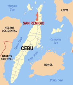 Map of Cebu with San Remigio highlighted | |
.svg.png) San Remigio Location within the Philippines | |
| Coordinates: 11°03′N 123°59′E / 11.05°N 123.98°ECoordinates: 11°03′N 123°59′E / 11.05°N 123.98°E | |
| Country | Philippines |
| Region | Central Visayas (Region VII) |
| Province | Cebu |
| District | 4th district of Cebu |
| Barangays | 27 (see § Barangays) |
| Government [1] | |
| • Type | Sangguniang Bayan |
| • Mayor | Mariano Martinez (LP) |
| • Vice mayor | Alfonso Pestolante |
| • Town Council |
Members
|
| • Representative | Benhur Salimbangon |
| Area[2] | |
| • Total | 95.27 km2 (36.78 sq mi) |
| Population (2015 census)[3] | |
| • Total | 57,557 |
| • Density | 600/km2 (1,600/sq mi) |
| • Voter (2016)[4] | 37,122 |
| ZIP code | 6011 |
| IDD : area code | +63 (0)32 |
| Income class | 3rd class |
| PSGC | 072243000 |
| Website |
sanremigio |
San Remigio (local pronunciation: /sænrəˈmiːjoʊ/) is a 3rd municipal income class municipality in the province of Cebu, Philippines. According to the 2015 census, it has a population of 57,557.[3] In the 2016 election, it had 37,122 registered voters.[4]
San Remigio celebrates its annual fiestas on 15 and 16 May in honor of their patron saints, San Isidro Labrador and San Juan Nepomuceno. The parish had just had their 150th anniversary since it has been founded in the year 1864.
History
San Remigio was formerly known as "Kanghagas", a kind of tree that grew there in abundance. When the Spanish conquistadores came, they identified a town site by clearing the kanghagas trees through self-help labor. Kanghagas was a part of barangay Punta.
Initially the visita of Kanghagas was within the jurisdiction of Bantayan. In 1850 Bogo established a parish, and the three barrios of Kanghagas, Lambusan and Victoria (Maarat) became under the civil governance of Bogo. Kangahagas was renamed Isabel after the queen of Spain. In 1864 these barrios establish a new parish named as San Juan Nepomuceno Parish (Redondo 1886, p. 165) and a new town was called San Remigio.
Barangays
San Remigio comprises 27 barangays:[2]
| PSGC | Barangay | Population | ±% p.a. | ||
|---|---|---|---|---|---|
| 2015[3] | 2010[5] | ||||
| 072243001 | Anapog | 3.4% | 1,951 | 1,816 | +1.37% |
| 072243002 | Argawanon | 7.2% | 4,118 | 3,996 | +0.57% |
| 072243003 | Bagtic | 1.9% | 1,078 | 934 | +2.77% |
| 072243004 | Bancasan | 2.9% | 1,644 | 1,423 | +2.79% |
| 072243005 | Batad | 2.6% | 1,488 | 1,377 | +1.49% |
| 072243006 | Busogon | 2.8% | 1,592 | 1,445 | +1.86% |
| 072243007 | Calambua | 2.5% | 1,450 | 1,350 | +1.37% |
| 072243008 | Canagahan | 2.6% | 1,489 | 1,377 | +1.50% |
| 072243009 | Dapdap | 3.2% | 1,825 | 1,415 | +4.96% |
| 072243010 | Gawaygaway | 2.5% | 1,423 | 1,426 | −0.04% |
| 072243011 | Hagnaya | 7.2% | 4,127 | 3,527 | +3.04% |
| 072243012 | Kayam | 2.3% | 1,350 | 1,307 | +0.62% |
| 072243013 | Kinawahan | 1.5% | 869 | 896 | −0.58% |
| 072243014 | Lambusan | 4.3% | 2,495 | 2,158 | +2.80% |
| 072243015 | Lawis | 2.2% | 1,251 | 1,079 | +2.86% |
| 072243016 | Libaong | 2.1% | 1,213 | 1,132 | +1.32% |
| 072243017 | Looc | 3.8% | 2,201 | 2,021 | +1.64% |
| 072243018 | Luyang | 4.1% | 2,343 | 2,152 | +1.63% |
| 072243019 | Mano | 6.4% | 3,698 | 3,179 | +2.92% |
| 072243020 | Poblacion | 9.3% | 5,356 | 4,309 | +4.23% |
| 072243021 | Punta | 5.5% | 3,174 | 2,659 | +3.43% |
| 072243022 | Sab‑a | 1.8% | 1,045 | 1,169 | −2.11% |
| 072243023 | San Miguel | 3.0% | 1,706 | 1,568 | +1.62% |
| 072243024 | Tacup | 4.1% | 2,354 | 2,269 | +0.70% |
| 072243025 | Tambongon | 5.4% | 3,100 | 2,727 | +2.47% |
| 072243026 | To‑ong | 2.3% | 1,307 | 1,163 | +2.25% |
| 072243027 | Victoria | 3.3% | 1,910 | 1,520 | +4.44% |
| Total | 57,557 | 51,394 | +2.18% | ||
Demographics
| Population census of San Remigio | |||||||||||||||||||||||||
|---|---|---|---|---|---|---|---|---|---|---|---|---|---|---|---|---|---|---|---|---|---|---|---|---|---|
|
| ||||||||||||||||||||||||
| Source: Philippine Statistics Office[3][5][6] | |||||||||||||||||||||||||
In the 2016 election, it had 37,122 registered voters, meaning that 64% of the population are aged 18 and over.[4]
Tourism
San Remigio has the longest shoreline of any municipality in Cebu. There are several beach resorts, as well as public beaches with long stretches of white sand.
Today, San Remigio has become a new diving destination. There are a few marine sanctuaries, with new dive sites being developed all the time. A PADI dive shop in San Remigio Beach Club caters to beginner and experienced divers who want to enjoy San Remigio's marine life.
The port of Hagnaya offers a frequent ferry service to Bantayan Island.
Schools
The town of San Remigio has many public elementary and secondary schools. Secondary schools are San Remigio National High School, Dapdap National High School, Lambusan National High School, Libaong National High School, Jose Martinez Memorial (Gawaygaway) National High School, San Miguel National High School & Luyang National High School. Each barangay has an elementary and primary school.
References
- ↑ "Municipality". Quezon City, Philippines: Department of the Interior and Local Government. Retrieved 31 May 2013.
- 1 2 "Municipal: San Remigio, Cebu". PSGC Interactive. Quezon City, Philippines: Philippine Statistics Authority. Retrieved 8 January 2016.
- 1 2 3 4 "Region VII (CENTRAL VISAYAS)". Census of Population (2015): Total Population by Province, City, Municipality and Barangay (Report). PSA. Retrieved 20 June 2016.
- 1 2 3 "2016 National and Local Elections Statistics". Commission on Elections. 2016.
- 1 2 "Region VII (CENTRAL VISAYAS)". Census of Population and Housing (2010): Total Population by Province, City, Municipality and Barangay (Report). NSO. Retrieved 29 June 2016.
- ↑ "Region VII (CENTRAL VISAYAS)". Census of Population (1995, 2000 and 2007): Total Population by Province, City and Municipality (Report). NSO. Archived from the original on 24 June 2011.
Sources
- http://web.archive.org/web/20130921103827/http://www.sanremigio.gov.ph/index.php?option=com_content&view=article&id=129&Itemid=25
- Ereccion de Pueblos: 1818-1887. (This contains the Spanish and original texts of the Creation of Towns: photocopied from the National Archives)
- Sendino y Redondo, Felipe (1886). Breve reseña de lo que fue y de lo que es la Diócesis de Cebú en las Islas Filipinas (in Spanish). Manila: Colegio de Sto. Tomas.
- Trota José, Regalado (2008). Curas de almas : a preliminary listing of parishes and parish priests in the 19th century Philippines based on the Guías de Forasteros, 1834-1898. UST Press. ISBN 978-9715064590.
External links
 |
Santa Fe ⛴ Hagnaya Bay | Hagnaya Bay (Visayan Sea) | Medellin | |
| Visayan Sea | |
Bogo City Tabogon | ||
| ||||
| | ||||
| Tabuelan |
Cebu City (capital) | |
| Municipalities |
|
| Component cities | |
| Highly urbanized cities | (Administratively independent from the province but grouped under Cebu by the Philippine Statistics Authority. Mandaue is grouped under the 6th legislative district of Cebu but still independent from the province.) |