San Miguel River (Colorado)
| San Miguel River[1] | |
|---|---|
 San Miguel at Naturita | |
| Basin | |
| Main source | 37°55′37″N 107°46′33″W / 37.92694°N 107.77583°W[1]) |
| River mouth |
Confluence with Dolores River 4,819 ft (1,469 m) 38°22′48″N 108°48′12″W / 38.38000°N 108.80333°WCoordinates: 38°22′48″N 108°48′12″W / 38.38000°N 108.80333°W |
| Progression | Dolores—Colorado |
The San Miguel River is a tributary of the Dolores River, approximately 81 miles (130 km) long,[2] in southwestern Colorado in the United States. It rises in the San Juan Mountains southeast of Telluride and flows northwest, along the southern slope of the Uncompahgre Plateau, past the towns of Placerville and Nucla and joins the Dolores in western Montrose County approximately 15 miles (24 km) east of the state line with Utah.
The San Miguel is more or less free flowing; however, diversion dams dot the river and alter flows. The San Miguel varies in gradient, from extremely steep in its upper reaches (forming a shallow, rocky, unnavigable stream) to more mellow in the lower sections (30–50 feet per mile (5.7–9.5 m/km) of drop, which offers the whitewater boater a variety of runs all within the class II+--III range). All told, the San Miguel drops over 7,000 feet (2,100 m) from an alpine ecosystem to the desert. The average flow is about 600 cu ft/s (17 m3/s).
Whitewater kayakers and boaters enjoy many sections on the San Miguel. Minimum suggested flows for small vessels is 250 cfs, with the river near Placerville usually becoming navigable in late April or early May. Several runs of varying length are commonly undertaken from there to the confluence with the Dolores, near the site of Uravan. The San Miguel is considered a continuous class 2 run with several class three rapids which become more challenging at higher flows, where the river's speed can make it difficult to stop and scout. Additional River hazards are three diversion dams that exist between Naturita and the Hwy 145 bridge East of Norwood . All of them are relatively easy to scout and portage, however. As the river meanders through an agricultural valley just East of Naturita, several cattle fences cross the river.
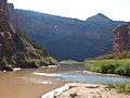 The mouth of the San Miguel - the confluence of the Dolores (muddy on the left) and the San Miguel (clear on the right)
 San Miguel River at low water
See also
References
- 1 2 "San Miguel River". Geographic Names Information System. United States Geological Survey. Retrieved 2011-01-27.
- ↑ "USGS National Atlas Streamer". United States Geological Survey. Retrieved 2015-01-19.