San Mateo–Hayward Bridge
| San Mateo–Hayward Bridge | |
|---|---|
|
Aerial view of the San Mateo–Hayward Bridge, with Foster City in the foreground | |
| Coordinates | 37°36′07″N 122°12′17″W / 37.6019°N 122.2047°WCoordinates: 37°36′07″N 122°12′17″W / 37.6019°N 122.2047°W |
| Carries |
Cars and trucks on 6 lanes of |
| Crosses | San Francisco Bay |
| Locale | Foster City and Hayward, California, U.S. |
| Other name(s) | San Mateo Bridge |
| Owner | Caltrans |
| Maintained by | Caltrans and the Bay Area Toll Authority |
| ID number | 35 0054 |
| Characteristics | |
| Design |
|
| Total length |
|
| Width | 41 metres (135 ft) roadway approach |
| Longest span | 757.2 feet (230.8 m) |
| Number of spans |
|
| Clearance below | 134.5 feet (41.0 m) |
| History | |
| Designer | Caltrans, Bay Toll Crossings Division[1] |
| Constructed by |
|
| Fabrication by | Murphy Pacific Corporation, Emeryville[1] |
| Construction cost | US$70,000,000 (equivalent to $498,000,000 in 2015) |
| Opened | |
| Statistics | |
| Daily traffic | 93,000 |
| Toll |
Cars (westbound only) $5.00 (cash or FasTrak), $2.50 (carpools during peak hours, FasTrak only) |
|
San Francisco Bay Bridges | |
.jpg)
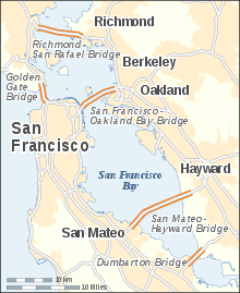
The San Mateo–Hayward Bridge (commonly called the San Mateo Bridge) is a bridge crossing the U.S. state of California's San Francisco Bay, linking the San Francisco Peninsula with the East Bay. The bridge's west end is in Foster City, a suburb on the eastern edge of San Mateo. The east end of the bridge is in Hayward. It is the longest bridge in California and the 25th longest in the world by length. The bridge is owned by the state of California, and is maintained by Caltrans, the state highway agency. Further oversight is provided by the Bay Area Toll Authority.
The bridge is part of State Route 92, whose western terminus is at the town of Half Moon Bay on the Pacific coast. It links Interstate 880 in the East Bay with U.S. Route 101 on the Peninsula. It is roughly parallel to and lies between the San Francisco–Oakland Bay Bridge and the Dumbarton Bridge, and is sometimes used by commuters to avoid traffic delays due to emergencies on those bridges.
History and description
1929 original bridge
The San Francisco Bay Toll-Bridge Company issued US$4,500,000 (equivalent to $61,400,000 in 2015) in bonds [4] to raise a portion of the estimated US$7,500,000 (equivalent to $102,300,000 in 2015) budget required to build the first bridge. First-year operating revenues were anticipated to be US$868,469 (equivalent to $11,851,000 in 2015), but the original bridge lost money in its first year of operation.[5]
The original bridge, known as the San Francisco Bay toll bridge, opened on 2 March 1929[6][7] after approximately a year of construction. It was a privately owned venture and was then the longest bridge in the world.[2] The original bridge was mostly a two-lane causeway trestle with five 300-foot (91 m) truss spans in the center[8] incorporating a vertical lift over the main shipping channel. Clearance when the lift was down to allow road traffic over the bridge was 35 feet (11 m), and clearance with the lift up to allow marine traffic to pass the bridge was 135 feet (41 m).[9]
The original drawbridge played a minor role in the history of the Stanford Axe. When Stanford students stole the Axe back from Cal in April 1930, the getaway car was presumed to be traveling the shortest route, which would be over the bridge, and pursuing Cal students gave chase. The operator on duty, who was a graduate student at Stanford, learned that Cal students were causing the increased traffic in pursuit of the Axe, so he raised the draw and stopped traffic. In fact, the getaway car was traveling back to Palo Alto via San Jose.[10]
Although the initial press was favorable, daily traffic fell from the opening months[11] and never exceeded 2,000 cars per day until 1947.[5] The State of California purchased the bridge on 12 September 1951 for US$6,000,000 (equivalent to $54,800,000 in 2015). By 1955, traffic exceeded 9,000 cars per day,[5] and in 1957, traffic was stopped an average of six times per day to allow ship traffic to pass the bridge.[2] The bridge originally had pole lights along the entire stretch, which were later abandoned except over the vertical lift span. Traffic on the bridge increased from 3,000 cars per day in 1929[11] to 56,000 cars per day in 1968.[7] Before the new bridge was complete, California put the original truss spans up for sale in 1965, with the buyer obligated to remove all five truss spans after completion of the 1967 bridge.[8]
1967 orthotropic bridge
With increased road and marine traffic, a bill was introduced in 1961 by State Senator Richard J. Dolwig to fund a new fixed high-level bridge to replace the 1929 lift-bridge.[12] The modern span, which began construction on 17 July 1961,[5] opened for traffic in 1967 at a cost of US$70,000,000 (equivalent to $498,000,000 in 2015).[2] The originally designed upgrade would retain the existing lift span (along with the attendant delays due to passing ship traffic), adding a second deck to the truss spans and widening the existing trestles to four lanes,[13] but the California Toll Bridge Authority added US$30,000,000 (equivalent to $238,000,000 in 2015) to the project budget in September 1961 to replace the existing lift span with a fixed high-level double-deck span,[13] which would have been similar in appearance to the nearby 1956 Richmond–San Rafael Bridge.[14]
By that time, prior phases of the project had already been awarded to relocate the toll plaza from San Mateo to Hayward on new fill[15] and bids were taken for the new eastern trestle,[16] with trestle construction awarded to Peter Kiewit Sons'.[17] The finished single-deck design was not finalized until January 1962, with work initially estimated to complete in 1965.[18]
The new span won two prizes in 1968: an ASCE Award for Outstanding Civil Engineering Achievement[19] and an American Institute of Steel Construction long-span prize bridge award.[1]
William Stephen Allen was retained as an architectural consultant,[18] although the bridge was designed by the Bay Toll Crossings Division (under Chief Engineer Norman C. Raab) of the California Department of Public Works. Chuck Seim, one of the design engineers working for Bay Toll Crossings, would later credit Allan Temko's criticism of Raab's economical truss design for the Richmond–San Rafael crossing for generating sufficient public pressure to drive the single-deck design.[14] Temko's article quoted Tung-Yen Lin as being against a repeat of the Richmond–San Rafael design, but Lin ultimately gave Temko the credit for the design.[20] Raab retired and his successor, E.R. "Mike" Foley, was willing to incorporate aesthetic considerations, resulting in the final design.[14] The western highrise span features an all-steel superstructure, with an orthotropic deck over two parallel box girders, following the construction of several smaller test bridges using the same orthotropic deck technology.[21] It was the first large-scale use of an orthotropic deck, which reduces weight, and thus seismic loading, although the bridge is expected to receive moderate to major damage following an earthquake.[22]
Murphy Pacific Marine built the Marine Boss floating barge-crane in 1966 with a 500-short-ton (454 t) capacity to perform the heavy box girder and deck-section lifts.[23] The heavy lift capacity of Marine Boss enabled Murphy Pacific to raise much longer prefabricated girders than existing barge cranes would have allowed. Box girder and deck sections were fabricated in Murphy Pacific's Richmond yard and were carried by Marine Boss to the bridge construction site.[24] Marine Boss was sold for scrap in 1988 to Weeks Marine in New Jersey,[25] who renamed it the Weeks 533 and refurbished it. Weeks 533 has since been used for several notable heavy lifts, including moving the Concorde and Enterprise onto the Intrepid Sea, Air & Space Museum and lifting the downed hull of US Airways Flight 1549 from the Hudson River.[26][27]
The total length of the bridge is 7 miles (11.3 km), which is made up of a western 1.9-mile (3.1 km) highrise section and an eastern 5.1 miles (8.2 km) trestle section. 425,000 cubic yards (324,936 m3) of fill were used at the Hayward end to reclaim land for placing the toll plaza and administrative buildings.[17] The eastern trestle span was built on 4,840 prestressed hollow concrete piles, each 60–90 feet (18–27 m) long.[17] The contractor built a casting yard in Richmond to produce the concrete piles continuously. The new eastern trestle span was completed in 1963[28] and traffic over the existing 1929 bridge was moved over to it.[29]
Work on the western highrise span was bid in October 1964[30] and commenced in 1965. It crosses a shipping channel, with an orthotropic main span that is 750 feet (229 m) long (at the time, the longest girder span in the United States)[14][29][30] and has a vertical clearance of 135 feet (41 m).[2] The main span is flanked by two orthotropic back spans which are each 375 feet (114 m) long, and there are seven orthotropic side spans on the approach to each back span. Each of these side spans are 292 feet (89 m) long.[21] Although these spans appear to be formed from continuous box girders, they consist of alternating anchor spans and suspended spans. Anchor spans rest on top of two adjacent piers and cantilever over each side slightly, and suspended spans are hung between the ends of two adjacent anchor spans.[24] There are an additional nine 208-foot (63 m) steel spans carrying a concrete deck on the San Mateo side of the highrise, and ten steel spans carrying a concrete deck on the Hayward side, ranging from 186–208 feet (57–63 m).[29] The bridge carries about 93,000 cars and other vehicles on a typical day, almost double its original projected design capacity of 50,000 vehicles per day.[30]
The steel deck of the bridge, approximately 418,000 square feet (38,833 m2), was paved with an epoxy asphalt concrete wearing surface in two layers.[31] The San Mateo Bridge was the first deployment of an epoxy asphalt concrete wearing surface.[32] As of 2005, the original wearing surface was still in use,[33] but was subsequently replaced in 2015.[34]
The highrise section was initially built with six lanes and the eastern causeway with four lanes (two in each direction). The causeway section was a perennial traffic bottleneck until it was expanded to six lanes in 2002,[3] along with much needed improvements in its connections with Interstate 880 in Hayward.
Bus service over the bridge is provided by AC Transit's Line M Transbay service.

High-voltage power lines built by PG&E in the 1950s parallel the bridge all the way across the bay.[35] They provide power to the peninsula and San Francisco.
Upgrades and repairs
Seismic upgrades (1997–2000)
The bridge was closed in the wake of the 1989 Loma Prieta earthquake as a precaution, but reopened on 18 October 1989.[36] It underwent an extensive seismic retrofitting to protect against earthquake damage from 1997 through 2000.[37]
Widening (2002–2003)
The bridge was considered the worst evening commute in the Bay Area,[38] which ended with the completion of a new eastern trestle carrying westbound bridge traffic in 2002.[3] Eastbound bridge traffic took over the old trestle completely, although eastbound traffic was not expanded to three lanes until February 2003.[39] Funded as part of BATA's regional Measure (RM) 1 program, which raised bridge tolls,[38] the new low-rise trestle portion of the bridge added 10 feet (3.0 m) shoulders on both sides in both directions and effectively widened traffic from four to six lanes, matching the configuration of the high-rise portion of the bridge.[40][41] With the completion of the new westbound trestle, the speed limit on the bridge was raised to 65 miles per hour (105 km/h).[42]
Seismic beam (2010–2012)
A beam, which had been added as part of the seismic retrofit project, was found in a cracked condition during a routine inspection in October 2010.[43] The beam, which was on the westbound approach to (east of) the highrise section, was patched with a steel plate as an emergency repair, and permanent repairs, requiring a weekend shutdown, were completed two years later.[44]
Repaving (2015)
After nearly forty years of service from the original orthotropic deck wearing surface, Myers and Sons Construction, a partnership between C. C. Myers and Sterling Construction Company, was the selected bidder to remove and replace the wearing surface on the highrise portion in 2015.[34] The work required two full weekend closures on 8–11 May 2015 and 22–25 May 2015.[45] The new polyester concrete wearing surface, developed by Caltrans and used to great success in other Bay Area bridges,[46] is anticipated to be at least as durable as the original epoxy asphalt concrete, according to laboratory tests conducted at the University of Missouri-Columbia.[47][48]
The bridge was closed to traffic, for the first time since opening, starting at 10pm on Friday, May 8, 2015, for resurfacing and maintenance. The bridge reopened before 4am on Monday, May 11, 2015.[49] It closed again for the final phase over Memorial Day weekend, May 22–25, 2015, fully reopening by 4:55am on May 25.[50]
Werder Pier
.jpg)
After the new bridge was built, the old bridge was demolished but the western approach (the trestle span up to the original truss spans) was purchased by the County of San Mateo in 1968 for the nominal sum of US$10 (equivalent to $70 in 2015)[7] and retained as the 4,055 feet (1,236 m) Werder Fishing Pier,[2] which was known as one of the best places to catch sharks in San Francisco Bay.[51] San Mateo County operated Werder Pier under a lease agreement with Caltrans, which stated that Caltrans may temporarily revoke the lease in order to perform use the pier as a staging area for repairs to the 1967 span, and that San Mateo County must maintain the pier and keep it open for public use for twenty-five years.[7]
Werder Pier was closed to the public in 1996, when Caltrans used it as an equipment staging area for the seismic retrofit of the 1967 span.[52] In addition, there were liability concerns since the pier's structure had degraded due to exposure to marine elements.[7] A report was prepared for the County in 2004; the cost of rehabilitating the pier and providing some improvements was estimated at up to US$7,200,000 (equivalent to $9,000,000 in 2015),[7] depending on a more detailed evaluation of the pier's condition, since the investigation for the report revealed numerous cracks, spalls and exposed reinforcing steel. However, the report also stated the pier did not require any seismic retrofitting.
As of 2013 ownership of the parking lot and land access to the pier was transferred to Foster City.[52] Initial concepts for the newly-acquired space included a possible ice rink[53] and ferry terminal, but the land was deemed too environmentally sensitive to support high-intensity use.[54] The park carried an interim name of Werder Park,[55] and was dedicated as Bridgeview Park for a grand opening on June 27, 2015.[56]
Tolls
Tolls are only collected from westbound traffic at the toll plaza on the east side of the bridge. Since July 2010, the toll rate for passenger cars is $5.[57][58] For vehicles with more than two axles, the toll rate is $5 per axle.[59] Drivers may either pay by cash or use the FasTrak electronic toll collection device. During peak traffic hours, the two left lanes are designated HOV lanes, allowing carpool vehicles carrying two or more people or motorcycles to pass for a toll of $2.50. The next three lanes are FasTrak-only lanes. During non-peak hours the two HOV lanes become FasTrak-only lanes.
References
Notes
- 1 2 3 4 American Institute of Steel Construction (1968). "Prize Bridges 1968". AISC. Retrieved 14 January 2015.
- 1 2 3 4 5 6 "San Mateo–Hayward Bridge Facts". Caltrans. 1995. Retrieved 14 January 2015.
- 1 2 3 Cabanatuan, Michael (30 October 2002). "Expanded bridge set to open early". San Francisco Chronicle. Retrieved 14 January 2015.
- ↑ "ADVERTISEMENT: San Francisco Bay Toll-Bridge Company—First Mortgage 6½% Sinking Fund Bonds". Pittsburgh Post-Gazette. 22 November 1927. Retrieved 15 January 2015.
- 1 2 3 4 "The bridges of San Mateo County". San Mateo Daily Journal. 10 March 2008. Retrieved 19 January 2015.
- ↑ "San Mateo Bridge Opened By Coolidge; Autos Crowd It Full". San Jose News. 4 March 1929. Retrieved 15 January 2015.
- 1 2 3 4 5 6 Concept Marine Associates (March 2004). County of San Mateo: Werder Pier Restoration Feasibility Study (PDF) (Report). County of San Mateo, Environmental Services Agency, Parks and Recreation Division. 20307/0142/1301. Retrieved 14 January 2015.
- 1 2 "San Mateo-Hayward Spans Are for Sale" (PDF). California Highways and Public Works. California Department of Public Works: 30. January–February 1965. Retrieved 21 January 2015.
- ↑ "S. M. Bridges Tie County to Valleys". The Times. San Mateo. 7 October 1936. Retrieved 20 January 2015.
- ↑ Alkire, David (18 November 1966). "Operation 'Immortal 21' Highlights Spirited History of Stanford's Axe". The Stanford Daily. 150 (41). Retrieved 15 March 2016.
- 1 2 "New San Mateo Bridge Reports Heavy Traffic". San Jose News. 6 April 1929. Retrieved 15 January 2015.
- ↑ "Hearing Due Tuesday on S. M. High Level Bridge". The Times. San Mateo. 27 April 1961. Retrieved 20 January 2015.
- 1 2 "Toll Bridge Project is Expanded" (PDF). California Highways and Public Works. California Department of Public Works: Inside Front Cover. September–October 1961. Retrieved 21 January 2015.
- 1 2 3 4 Redman, Sam; Seim, Chuck (2013). Charles Seim: The Bay Bridge Oral History Project (PDF) (Report). Berkeley: The Bancroft Library, University of California. Retrieved 6 February 2015.
- ↑ "S.M.-Hayward Bridge Mole Job Is Awarded" (PDF). California Highways and Public Works. California Department of Public Works: 71. March–April 1961. Retrieved 21 January 2015.
- ↑ "Bids Will Be Opened July 11, On San Mateo-Hayward Bridge Trestle" (PDF). California Highways and Public Works. California Department of Public Works: 21. May–June 1961. Retrieved 21 January 2015.
- 1 2 3 Raab, Norman C. (January–February 1963). "San Mateo-Hayward Bridge" (PDF). California Highways and Public Works. California Department of Public Works: 25–31. Retrieved 21 January 2015.
- 1 2 "San Mateo-Hayward Bridge Design Is Approved" (PDF). California Highways and Public Works. California Department of Public Works: 61. January–February 1962. Retrieved 21 January 2015.
- ↑ American Society of Civil Engineers (2015). "Outstanding Civil Engineering Achievement (OCEA) Award Past Award Winners". ASCE. Retrieved 14 January 2015.
- ↑ Swent, Eleanor; Lin, T.Y. (2001). 'The Father of Prestressed Concrete': Teaching Engineers, Bridging Rivers and Borders, 1931 to 1999 (Report). Berkeley: Regional Oral History Office, The Bancroft Library, University of California. Retrieved 6 February 2015.
I had an argument with this old engineer, my senior. Norman Raab was in charge of all the bay bridges. Later it came time to build the San Mateo Bridge. He proposed the San Mateo Bridge to be double deck, one on top, one on bottom, like the Richmond-San Rafael Bridge. He proposed steel trusses. Double deck. The Richmond-San Rafael Bridge, one deck on top, one deck below. Save money according to him. Probably did save some money. Now come to the San Mateo Bridge, he wants to design it just like the Richmond-San Rafael Bridge which he is used to. And then, I think, lots of people objected to the look of this type of bridge. Double deck and steel truss. Allan Temko wrote an article against this. And that caught public attention. And in his article, he quoted T.Y. Lin. He had consulted me and whatever I said and--then we hit the headlines, so that Governor Brown called a meeting, a public hearing on the bridge design. And came in steel executives, board chairman or president of American Steel Company, et cetera; we all met in a big hall--I cannot remember where in San Francisco. At that meeting the steel people were so powerful, you know! [laughs] They declared it must be a steel bridge. It must be a girder bridge as hinted in Allan Temko's article and then was adopted with the approval of the steel board chairman. I was too young to say anything. I was there but I didn't say anything. However, I was, a few weeks before that meeting, quoted by Allan Temko as being against this repetition of the Richmond-San Rafael Bridge. And that made me a nonconformist. And also, there was an engineering uproar against me that I shouldn't be speaking something against another engineer. This kind of thing. But Allan Temko was for the critique and he changed it to a girder design. Hence the San Mateo Bridge was designed of the girder type. Among the longest girders in the world. Steel girder, with a main span of 750 feet. It's beautiful, single deck. Much better than Richmond-San Rafael Bridge. [...] You know who designed the bridge? Allan Temko did! He initiated the whole thing. Without him, this would have been another one like the Richmond-San Rafael, steel truss, double deck. He insisted on a single deck and a girder bridge.
- 1 2 Mangus, Alfred R. (October 2005). "California's Orthotropic Steel Bridges" (PDF). STRUCTURE. Retrieved 15 January 2015.
- ↑ "Toll Bridge Seismic Retrofit Program". Bay Area Toll Authority. 6 September 2013. Retrieved 15 January 2015.
- ↑ Mangus, Alfred R. (30 August 2008). California Orthotropic Bridge Bus Tour (PDF). Orthotropic Bridge Conference. Sacramento, California. Retrieved 15 January 2015.
- 1 2 Murphy, Jay (June 2007). "Early California Accelerated Steel Bridge Construction". Steel TIPS: Technical Information & Product Service. Structural Steel Educational Council. Retrieved 2 August 2015.
- ↑ "New life for the Marine Boss". Cranes Today. 2 January 2001. Retrieved 15 January 2015.
- ↑ Gauvin, Brian (22 August 2012). "World's most famous crane? Shuttle move shines spotlight on Weeks". Professional Mariner. Retrieved 15 January 2015.
- ↑ Rose, Lisa (6 June 2012). "Space shuttle Enterprise is the latest historic vessel picked up by legendary Jersey City crane". New Jersey Star-Ledger. Retrieved 15 January 2015.
- ↑ "State-Owned Toll Bridges: San Mateo-Hayward and Dumbarton Bridges" (PDF). California Highways and Public Works. California Department of Public Works: 56–57. November–December 1963. Retrieved 21 January 2015.
- 1 2 3 "Tower Work to Start on Bridge". The Times. San Mateo. 23 October 1965. Retrieved 20 January 2015.
- 1 2 3 "San Mateo-Hayward Bridge" (PDF). California Highways and Public Works. California Department of Public Works: 65. September–October 1964. Retrieved 21 January 2015.
- ↑ Seim, Charles (1973). "Skid Resistance of Epoxy Asphalt Pavements on California Toll Bridges". Skid Resistance of Highway Pavements. American Society for Testing and Materials. pp. 41–59. Retrieved 20 January 2015.
- ↑ "Epoxy Asphalt Polymer Concrete". ChemCo Systems. 2014. Retrieved 20 January 2015.
- ↑ Mangus, Alfred R. (March–April 2005). "A Fresh Look at Orthotropic Technology". Public Roads. 68 (5). Retrieved 20 January 2015.
- 1 2 "Sterling Construction Company, Inc. is the selected contractor for a San Mateo Bridge Project Valued at Approximately $25 Million" (PDF) (Press release). The Woodlands, Texas: Sterling Construction Company, Inc. 2 December 2014. Retrieved 20 January 2015.
- ↑ Weigel, Samantha (31 October 2013). "PG&E replacing transmission lines over Bay". The Daily Journal. San Mateo. Retrieved 15 January 2015.
- ↑ Appel, Ted (19 October 1989). "Toppled Road Predates Quake Reinforcements". Schenectady Gazette. UPI. Retrieved 15 January 2015.
- ↑ "San Mateo-Hayward seismic retrofit". Caltrans. 1995. Retrieved 14 January 2015.
- 1 2 Wilson, Marshall (15 June 1998). "Busting the San Mateo Bridge Bottleneck". San Francisco Chronicle. Retrieved 14 January 2015.
- ↑ "New lanes on San Mateo Bridge open today". San Mateo Daily Journal. 4 November 2002. Retrieved 19 January 2015.
- ↑ "Bay Area Toll Authority, Bridge Facts: San Mateo-Hayward Bridge".
- ↑ "Widening San Mateo-Hayward Bridge". Caltrans. 1998. Retrieved 14 January 2015.
- ↑ Cabanatuan, Michael (20 November 2003). "SAN MATEO / Speed limit on bridge jumps to 65 mph". San Francisco Chronicle. Retrieved 14 January 2015.
- ↑ Cabanatuan, Michael (15 October 2010). "San Mateo Bridge getting emergency beam repair". San Francisco Chronicle. Retrieved 14 January 2015.
- ↑ Cabanatuan, Michael (21 October 2012). "San Mateo Bridge work ahead of schedule". San Francisco Chronicle. Retrieved 14 January 2015.
- ↑ "Caltrans to Close San Mateo-Hayward Bridge Over Two Weekends May 8–11 & May 22–25" (PDF) (Press release). Oakland, California: Caltrans District 4. 20 April 2015. Retrieved 4 May 2015.
- ↑ Maggenti, Ric (October 2001). "Polyester Concrete in Bridge Deck Overlays Report" (PDF). Caltrans. Retrieved 20 January 2015.
- ↑ Chamarthi, Ravi Sankar (December 2012). Evaluation of Wearing Surface Systems for the Orthotropic Steel Deck of the San Mateo Hayward Bridge (M.S.). University of Missouri-Columbia. Retrieved 20 January 2015.
- ↑ Gopalaratnam, V. S.; Chamarthi, R. S. (December 2012). Evaluation of Wearing Surface Systems for the Orthotropic Steel Deck of the San Mateo Hayward Bridge (Report). California Department of Transportation.
Project 59A0742
- ↑ "San Mateo-Hayward Bridge Reopens After Resurfacing, Maintenance". NBC Bay Area. Bay City News Service. May 11, 2015. Retrieved May 25, 2015.
- ↑ "Both Directions Of San Mateo-Hayward Bridge Now Open". CBS San Francisco. Bay City News Service. May 25, 2015. Retrieved May 25, 2015.
- ↑ Jones, Ken. "San Mateo Pier". Pier Fishing in California. Retrieved 14 January 2015.
- 1 2 Okamoto, Steve (6 February 2013). "Werder Park (Not Pier)". City of Foster City. Retrieved 14 January 2015.
- ↑ Silverfarb, Bill (15 February 2013). "Ice rink at Werder Park?". San Mateo Daily Journal. Retrieved 22 July 2015.
- ↑ Silverfarb, Bill (3 April 2013). "Ice rink and ferry terminal unlikely for Foster City's Werder Park". San Mateo Daily Journal. Retrieved 22 July 2015.
- ↑ "Werder and Destination Parks" (PDF). City of Foster City. 7 May 2014. Retrieved 5 May 2016.
- ↑ "Bridgeview and Shorebird Parks Ribbon Cutting Grand Opening Celebration" (Press release). City of Foster City. 8 June 2015. Retrieved 5 May 2016.
- ↑ "Frequently Asked Toll Questions". Bay Area Toll Authority. 2010-06-01. Archived from the original on 2010-11-01. Retrieved 2010-06-29.
- ↑ "Toll Increase Information". Bay Area Toll Authority. 2010-06-01. Archived from the original on 2010-11-01. Retrieved 2010-06-29.
- ↑ "Toll Increase Information: Multi-Axle Vehicles". Bay Area Toll Authority. 2012-07-01. Retrieved 2013-12-29.
External links
| Wikimedia Commons has media related to San Mateo – Hayward Bridge. |
- Bay Area Toll Authority bridge facts
- Bridge at the California Department of Transportation website (page describes several "planned" improvements which have already been implemented)
- official project links at DOT website
- FasTrak – San Mateo–Hayward Bridge
- tolls at 511.org transportation information website
- Foley, E.R. (19 October 1967). "Bridge to Profoundly Affect Future—Foley". The Times. San Mateo. The Times of San Mateo ran a special commemorative issue on 19 October 1967 detailing the construction of the 1967 orthotropic span.
- Lenhart, Gary. "San Francisco–Oakland Bay Bridge, California, Postcards". Alamedainfo. Retrieved 14 January 2015. (has scans of old postcards depicting the 1929 span)
- Wiese-Fales, Jan (2011). "Bridges under troubled surfaces". University of Missouri Engineering. Retrieved 14 January 2015.
- "New Bridge To Be Longest In the World". San Jose News. 13 February 1929. Retrieved 15 January 2015. Provides a contemporary account of original (1929) bridge construction.
- Maggenti, Ric (October 2001). "Polyester Concrete in Bridge Deck Overlays Report" (PDF). Caltrans. Retrieved 20 January 2015.
- Gopalaratnam, V. S., and Chamarthi, R. S., "Evaluation of Wearing Surface Systems for the Orthotropic Steel Deck of the San Mateo Hayward Bridge", Final project report submitted to California Department of Transportation, Project 59A0742, December 2012, 151 pp.
- Raab, N.C. (October 1958). A Report to the Department of Public Works on Improvements to the San Mateo - Hayward Bridge (Report). Division of San Francisco Bay Toll Crossings, Department of Public Works, State of California. Retrieved 12 July 2016.
| Crossings of the San Francisco Bay | ||||
|---|---|---|---|---|
| ||||
