City of San Marino
| City of San Marino Città di San Marino | |||
|---|---|---|---|
| Castello | |||
|
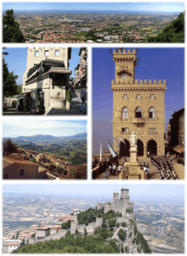
A collage of the City of San Marino. | |||
| |||
 San Marino's location in San Marino | |||
 City of San Marino San Marino's location in San Marino | |||
| Coordinates: 43°56′4.56″N 12°26′50.28″E / 43.9346000°N 12.4473000°E | |||
| Country |
| ||
| Foundation | September 3, 301 (traditional date) | ||
| Government | |||
| • Capitano | Maria Teresa Beccari (since 2009) | ||
| Area | |||
| • Total | 7.09 km2 (2.74 sq mi) | ||
| Elevation | 749 m (2,457 ft) | ||
| Population (31 October 2013) | |||
| • Total | 4,128 | ||
| • Density | 582.23/km2 (1,508.0/sq mi) | ||
| Time zone | CET (UTC+1) | ||
| • Summer (DST) | CEST (UTC+2) | ||
| Postal code | RSM-47890 | ||
| Climate | Cfb | ||

| San Marino Historic Centre and Monte Titano | |
|---|---|
| Name as inscribed on the World Heritage List | |
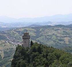
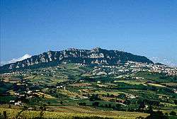 Monte Titano and three fortresses on top of it can be seen from many kilometers away | |
| Type | Cultural |
| Criteria | iii |
| Reference | 1245 |
| UNESCO region | Europe and North America |
| Inscription history | |
| Inscription | 2008 (32nd Session) |
The City of San Marino (Italian: Città di San Marino), also known simply as San Marino or locally as Città, is the capital city of the Republic of San Marino located on the Italian peninsula, near the Adriatic Sea. The city has a population of 4,128. It is on the western slopes of San Marino's highest point, Monte Titano.
Geography
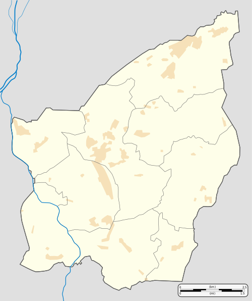
Although not the capital, most of the businesses are in Borgo Maggiore. It is the third largest city in the country, after Dogana and Borgo Maggiore. It borders the San Marino municipalities Acquaviva, Borgo Maggiore, Fiorentino, and Chiesanuova and the Italian municipality San Leo.
Akademio Internacia de la Sciencoj San Marino is centered here.
History
Due to its being the capital and previously the only city in San Marino, the history of this city is almost the same as the History of San Marino. For more information on that topic, see that article.
The city was founded by Saint Marinus and several Christian refugees in the year 301. From then on the city became a center of Christian refugees who fled from Roman persecution. As a result, the city become the oldest republic in Europe, for the republic's territory at that time only included the single city of San Marino.
The urban heart of the city was protected by three towers: the first, Guaita, constructed in the 11th century, was famous for being impenetrable, which to a great extent discouraged attacks on the city.
Due to the Crusades, it was felt necessary to construct a second tower, Cesta (13th century). But the Sanmarinense defensive system was not completed until the construction of a third tower, the Montale (14th century) - the smallest of all and constructed on the last of the summits of Monte Titano.
With the population of the city increasing, the territory of the country was extended by a few square kilometers. Since the Sanmarinese policy was not to invade or to use war to obtain new territories, it was by means of purchases and treaties that San Marino obtained the other eight castelli which make up San Marino.
Parishes
The City of San Marino has the following 7 parishes or wards (curazie):[1]
Economy
The economy of the city of San Marino has always been closely bound to that of the country. Until recently, the main economic activities of the locality were stone extraction and carving. Today, there is a more varied economy, including tourism, commerce, sale of postage stamps, and a small agricultural industry, although the latter is in decline.
Landmarks
The city is visited by more than three million people per year, and has developed progressively as a tourist centre. Of the tourists, 85% are Italian. There are also more than a thousand retail outlets, where one can find a great variety of products.
Main sights
- Basilica di San Marino
- Palazzo dei Capitani
- Palazzo Pubblico
- The Three Towers of San Marino
- Piazza del Titano
- Piazza Garibaldi
- Monastery of Santa Clara
- Grand Hotel San Marino
Transport
The town is known for its long, winding cobblestoned streets, as its altitude and steep approach put it beyond the reach of the San Marino Superhighway. San Marino is also notable in that cars are prohibited in much of the town center.
Before the Second World War, a railway was built from San Marino to Rimini under the dictatorship of Benito Mussolini. Its tunnels, and the railway station 'Piazzale Lo Stradone', still exist. Proposals for the reopening of this railway have been presented to the government on several occasions, but thus far without action.
There is a regular bus service to Rimini, and a 1.5 kilometres (0.9 miles) cable car line connects the capital with Borgo Maggiore.
A series of lifts also connects the upper part of town with the lower.
Sports
The city of San Marino has two football teams: the S.S. Murata and the S.P. Tre Penne. The city had the Olympic Flame pass through San Marino during the run-up to the 2006 Winter Olympics.
Photogallery
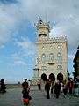 Palazzo Pubblico,
the Town Hall
 World War II memorial
 Via Paul III
 Piazza Giuseppe Garibaldi
 Statue of Liberty in the square of the Town Hall
 Panoramic view from Murata
International relations

Twin towns—Sister cities
City of San Marino is twinned with:
References
External links
![]() Media related to San Marino (city) at Wikimedia Commons
Media related to San Marino (city) at Wikimedia Commons
- (Italian) San Marino's page on giuntedicastello.sm
Coordinates: 43°56′4.56″N 12°26′50.28″E / 43.9346000°N 12.4473000°E