San Lorenzo de El Escorial
| San Lorenzo de El Escorial | |||
|---|---|---|---|
| Municipality | |||
| |||
 San Lorenzo de El Escorial Location in Spain | |||
| Coordinates: 40°35′37″N 4°8′34″W / 40.59361°N 4.14278°WCoordinates: 40°35′37″N 4°8′34″W / 40.59361°N 4.14278°W | |||
| Country | Spain | ||
| Autonomous community | Madrid | ||
| Province | Madrid | ||
| Comarca | Sierra de Guadarrama | ||
| Founded | 18th century | ||
| Government | |||
| • Mayor | José Luis Fernández-Quejo del Pozo (PP) | ||
| Area | |||
| • Total | 56.4 km2 (21.8 sq mi) | ||
| Elevation | 1,032 m (3,386 ft) | ||
| Population (2009) | |||
| • Total | 17,889 | ||
| • Density | 320/km2 (820/sq mi) | ||
| Demonym(s) | Sanlorentinos / Gurriatos | ||
| Time zone | CET (UTC+1) | ||
| • Summer (DST) | CEST (UTC+2) | ||
| Postal code | 28200 | ||
| Website | Official website | ||


San Lorenzo de El Escorial, also known as El Escorial de Arriba is a town and municipality in the Community of Madrid, Spain, located to the northwest of the region in the southeastern side of the Sierra de Guadarrama, at the foot of Mount Abantos and Las Machotas, 47 kilometres (29 mi) from Madrid. It is head of the same name judicial party. The settlement is popularly called El Escorial de Arriba, to differentiate it from the neighbouring village of El Escorial, also known as El Escorial de Abajo.
The Monastery of El Escorial is the most prominent building in the town and is one of the main Spanish Renaissance monuments. Especially remarkable is the Royal Library, inside the Monastery.
The monastery and its historic surroundings were declared a World Heritage Site UNESCO on November 2, 1984, under the name of "El Escorial, monastery and site".
The site also enjoys protection on Spain's heritage register; since June 21, 2006, it has been protected by the Community of Madrid as a Property of Cultural Interest.
San Lorenzo de El Escorial is located on the southern slopes of the Mount Abantos (elevation 1753 m). The average altitude of the municipality is 1,032 metres (3,386 ft), and most of the urban area is above 1,000 metres (3,300 ft). The hamlet initially sprang up around Monastery of El Escorial, gradually extending up the mountain. In the 20th and 21st centuries, the town underwent a strong urban expansion, particularly towards the southeastern side of Mount Abantos.
Geography
Elevation and hydrography
The township's average altitude is 1,032 metres (3,386 ft). Most of the town is situated at about 1,000 metres (3,300 ft) above sea level, including the Monastery of El Escorial, which lies approximately 28 metres (92 ft) above the town. The highest part is the top of Mount Abantos, which is 1,753 metres (5,751 ft) above sea level.
The town covers a total area of 56.4 square kilometres (21.8 sq mi), most of which is mountainous terrain. In the south of the municipality is the Circo de El Escorial, bordered by the southern slopes of Mount Abantos to the south and the Las Machotas hills to the north. North, along the slope of Cuelgamuros, lies the Valle de los Caídos (English: Valley of the Fallen), near the border with Guadarrama. Towards the Southwest, the municipality extends down to El Escorial by the parks and gardens of the Casita del Príncipe.
San Lorenzo de El Escorial lies in the watershed of the Guadarrama river. The Aulencia river, born in Las Machotas, is the main tributary of the Guadarrama, after crossing the neighbouring village of El Escorial. The streams include small reservoirs.
Vegetation
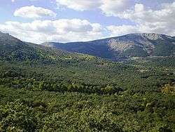
The types of vegetation differ due to the municipality's fluctuation in altitude. In its lower altitudes, about 3,000 ft (910 m), there are pastures with narrow-leafed ash (Fraxinus angustifolia); and in the forest of La Herrería grow Pyrenean oaks (Quercus pyrenaica), sweet chestnuts (Castanea sativa) and Montpellier maples (Acer monspessulanum).
In the higher altitudes (1,000–1,200 m or 3,300–3,900 ft) appear maritime (Pinus pinaster) and stone pines (Pinus pinea), as well as holm oaks (Quercus ilex), prickly junipers (Juniperus oxycedrus) and laudanum (Cistus ladanifer). Up to 4,000 feet (1,200 m) grows Scots pine (Pinus sylvestris) and black pine (Pinus nigra).
San Lorenzo de El Escorial also has some allochthonous in its mountain areas, plant species as beech (American beech), cedars, larches, Lawson cypresses (Chamaecyparis lawsoniana), and sycamores (Acer pseudoplatanus). Students of a forestry school planted these trees during the early 20th century.
There are also trees of historical significance, including giant sequoias (Sequoiadendron giganteum), planted in the 18th century in the parks and gardens of the Casita del Príncipe.
Much of the municipality is contained within the "Abantos pine forest" and the Herrería zone, a protected nature area since 1961 and extends to an area that San Lorenzo de El Escorial shares with Santa María de la Alameda.
The center of environmental education Arboreto Luis Ceballos houses a collection of over 200 species of trees and bushes native to the Iberian Peninsula and Balearic Islands.
History


The history of San Lorenzo de El Escorial is inexorably linked to the construction of the monastery and the town named El Escorial. The first historical references of this building date year 1558 where Philip II of Spain appointed a commission to find a proper place for the site, architects, doctors and quarrymen, among other guilds.[1]
Hamlet El Escorial met physical conditions for carrying out such company.[2] Its abundance of forests, quarries and game reserves, the quality of its water and its place in the geographic center of Spain, at the foot of the mount Abantos, were determining factors for the final choice, which took place in 1561.
Builders placed the first stone of the monastery on April 23, 1563. A year earlier, Philip II of Spain began efforts to acquire the land adjacent to the site of the future monastery, with the intention of creating a territory of realengo, real site de El Escorial, intended for agriculture, fishing, hunting and recreational uses. Among them were the Dehesa of the ironworks of Fuentelámparas (today called La Herrería), located in the current term of San Lorenzo de El Escorial, and La Granjilla of the Fresneda, farms in the neighbouring village of El Escorial.
Construction lasted 21 years, which transformed the urban and social environment of El Escorial. The hamlet became a villa in 1565.[3] A Lord Mayor exercised rule over the villa. The Lord Mayor's authority did not extend to the game reserves that the Crown managed directly, nor to agricultural uses managed by the monastery's Prior.
Through two Papal Bulls issued dated 1585 and 1586, the Roman Catholic Church removed the monastery from the control of the powerful Archbishop of Toledo and placed it under the monastery's Prior.
This administrative structure remained well into the 18th century, when the monarch Carlos III imposed a new territorial and administrative framework. The construction of houses, expressly prohibited in the outskirts of the monastery, was the cause of a dispute that faced the municipal authorities, who promoted a modification of the rules, and those who sought to restrict new construction. The subject was particularly delicate in those days, given the frequent visits of the Royal family to the site; these visits led to an increase in demand for land to build houses and support buildings mainly for civil servants working in the Royal household.
The resolution of the conflict came from King Carlos III, who, on May 3, 1767, authorized housing next to the market of the monastery, which was the birth of the municipality of San Lorenzo de El Escorial and the beginning of a process which culminated in the emancipation of the town from El Escorial. The development of this new Hamlet was very fast, reaching a population of more than a thousand only a few years afterCarlos III allowed the town's expansion.
The new settlement emerging at the foot of the monastery did not achieve self-rule until much later. The administrative structure designed by Philip II of Spain was blurring, first with the appointment of a Governor by Carlos III—detrimental to the powers of the Lord Mayor and El Escorial's Prior—and, subsequently, with the privatization of land.
This was key to the structural development of the current municipality of San Lorenzo de El Escorial, since this privatization extended over most of the royal lands except for the Herrería farms, land surrounding the monastery, the Príncipe and the Infante Casitas.
On September 26, 1836, San Lorenzo de El Escorial became an independent municipality. In 1887, it elected its first mayor. To date, 22 people have served in this role.
During the Spanish Civil War (1936–1939), the people remained loyal to the Republican government and briefly changed the town's name to El Escorial of the Sierra.[4]
Today the city of San Lorenzo de El Escorial consists of 12 localities: Colmenar of the Arroyo, Colmenarejo, El Escorial, Fresnedillas the olive, Navalagamella, Chavela Robledo, Saint Mary of the Alameda, Valdemaqueda, Valdemorillo, Villanueva of the pardillo and Zarzalejo, and the monastery of San Lorenzo de El Escorial.
Demography
San Lorenzo de El Escorial had 17,346 inhabitants, according to the National Institute of statistics (INE), as of 2008. At that time It had a population density of 307.55 inhabitants/square km (796.55 inhabitants/square mile), similar to other municipalities like El Escorial, but much lower than the regional average of the Comunidad de Madrid (808.17 inhabitants/square km (2,093.16 inhabitants/square mile)). The density was more than three times the Spanish average of 94.06 inhabitants/square km (243.62 inhabitants/square mile).
As of 2006, 51.7% of San Lorentinos were women and the remaining 48.3% were men. Foreigners represent 10.07% of the total population. The average age was 37.8 years. The annual population growth was 4.2%.
The transient population of San Lorenzo de El Escorial is very high. This is a major residential site; second homes proliferated with usage during weekends and vacation periods. In addition, the municipality receives daily large numbers of tourists attracted by its historical and natural heritage.
| 1996 | 1998 | 1999 | 2000 | 2001 | 2002 | 2003 | 2004 | 2005 | 2006 | 2007 | 2008 |
|---|---|---|---|---|---|---|---|---|---|---|---|
| 10,828 | 10,995 | 11,350 | 11,783 | 12,455 | 13,164 | 14,358 | 14,971 | 14,364 | 16,005 | 16,531 | 17,346 |
Note: 1996 figures are referring to May 1 and the other to January 1. Source: INE
Economy
Tourism, hospitality and trade are the main economic activities of San Lorenzo de El Escorial. The municipality is one of the most important tourist destinations in the community of Madrid. Visitors usually make day trips with Madrid tourism as a starting point. The number of tourists staying overnight are insignificant as in other historical cities in the region, such as Alcalá de Henares, Aranjuez or Chinchón.
In recent years, the town has attempted to consolidate hotel tourism, trade fairs, conventions and cultural and educational nature courses. The Universidad Complutense holds summer courses to promote San Lorenzo de El Escorial as a Euroforum installations. The municipality has 10 hotels with a total of 611 rooms (year 2006).
Inside of this municipality are two of the most visited monuments in the nation national. The Monastery of El Escorial is the second most visited monument with highest number of visits (504,238 tourists 2004), short of the Royal Palace in Madrid (720,710 in the same year). The Valley of the Fallen, located on the outskirts of town, is the third in the national list (407,578).
Construction is another economic activity on the rise in San Lorenzo de El Escorial. Although much of its area is protected, as with the Herrería forests, the town has experienced strong urban growth in recent years, with the creation of new housing developments in areas that lack legal protection from development. This is the case of the southeastern slope of Mount Abantos, which has many newly constructed neighbourhoods, especially after the August 21, 1999, fire that burned 450 acres (1.8 km2) of pine.
Main sights


.jpg)
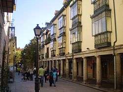
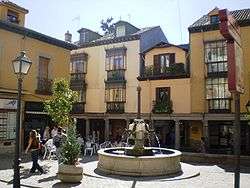
The town has an important historical-artistic, urban and cultural heritage, a result of its link with the Spanish crown. It adds relevant ecological, geological and archaeological values.
Part of the monument is listed with the heritage UNESCO.[5] In addition, this site has been awarded good of cultural interest, in the category of historical sites, with the name of "Escorial: monastery, natural and cultural environment", from the community of Madrid.[6]
The last legal figure, approved by Decree 52/2006 (June 21), also includes the towns of El Escorial, Zarzalejo and Saint Mary of the Alameda. This is the area which was within the so-called domain of Philip II, with which the monarch delineated the perimeter of the royal site in the area around the Monasterio.[7]
World Heritage sites
On November 2, 1984, together with the celebration of the IV centenary of the placement of the last stone during the monastery's construction, the World Heritage Committee (World Heritage Committee) of the UNESCO, meeting in Buenos Aires (Argentina), included "El Escurial, monastery and site" on the list of the heritage (World Heritage List).
This entry defines territorial protection for the Monasterio de El Escorial, the Casita of Infante (or up) and the Casita del Principe (or down), Palace, El Escorial: * "' Monasterio de El Escorial" '. This building, one of the main Renaissance monuments Spain, was erected in the last third of the 16th century on the mount Abantos, slope 3,373 ft (1,028 m). Juan Bautista de Toledo, originated the project that was finished, after his death, by Juan de Herrera, who imposed a new architectural style.[8] Occupies an area of 358,729 square feet (33,327 square meters) and has 16 patios, 88 sources, 13 oratorios, 15 Cloisters, 86 stairs, 9 towers, 1,200 doors and 2,673 Windows. Its main façade is 679 feet (207 m) in length. The most important parts of the building, include the Pantheon of Kings, the Real Basilica and Real library. From the sixteenth, the Escorial monastery has been described as "the eighth wonder of the world".
The Príncipe and the Infante cottages are two mansions neoclásicos 18th century. Both were built by Villanueva John as recreation sites for Carlos IV, then Prince of Asturias, and his brother Infante Bourbon Gabriel, respectively.
The territorial scope of protection laid down in the list of the heritage is currently in the process of being enlargement. The Spanish authorities intend to extend the UNESCOheritage declaration to all the space that was included within the original decree of Philip II.
Historical site
The municipality of San Lorenzo de El Escorial and other historical-artistic group have been incorporated into the legal figure of the historical territory (historical site) of "El Escorial: monastery, site and natural and cultural environment", according to Decree 52/2006 (June 21 BOCM) community of Madrid.
Here are different buildings and natural enclaves located within its Township and other located El Escorial, Zarzalejo and Saint Mary of the Alameda. Monumental sets and landscape sanlorentinos are highlighted below:
- "Chair Philip II",[9] where, according to legend, sat the monarch to view the progress of the works of the monastery, although it is believed that, in fact, was a vettones offerings altar.[10]
- "' The Herrería" ', historic farm, formerly known as the Dehesa of the Fuentelámparas ironworks, possessing great ecological interest. It is populated by forests fresnos and oaks.
- "' Del Castañar" ', historic farm with important environmental attractions.
- "' Park of the Casita" '. Parks and gardens built in this neoclassical Stupinigi environment are shared between the municipalities of El Escorial and San Lorenzo de El Escorial. Not building, which is in the first place.
- "' Houses of offices" '. The first two were built by Juan de Herrera 16th century and the third, Villanueva John work data 18th century. Currently are home to a small church and different facilities managed by the Town Council of San Lorenzo de El Escorial. This is the case of the House of culture of the municipal library, the tourist office, the Conservatory professional of music father Soler and the Royal Centre for integrated music and training in plastic and artistic. Furthermore, the first House of offices is provisional headquarters of the Instituto de Estudios Herrerianos, which will host the legacy of the architect and investigator Luis Cervera Vera.
- houses by Juan de Villanueva
- "' Real Colosseum of Carlos III" ', built in the 18th century, popularly known as the Bombonera theatre.[11]
- "' The company home" '. Drawn on 16th century by Mora Francisco today serves as headquarters to University Maria Cristina.
- "' Valley of the fallen" '. By extension, is included within the historical territory of the "El Escorial: monastery, site and natural and cultural environment" This funeral monument 20th century. Built on the initiative of the dictator of Francisco Franco, is perched on the Risco of Nava 4.56 ft (1.39) m altitude, in the place known as Cuelgamuros. A 490 ft (150 m) cross chairs the monumental, consisting of a Basilica carved on stone, an Abbey, and an Inn. Their artistic values, include the sculptures of the evangelists by D'avalos John with a size 59 ft (18 m), situated at the base of the cross.
Celebrities
_-_Prado.jpg)
San Lorenzo de El Escorial had close historical ties with the Spanish Crown, as place of residence and burial site of different monarchs from both Habsburg and Bourbon lines.
The presence of the Kings attracted different personalities from the world of culture and the arts towards the municipality. Apart from the long list of architects, sculptors and painters who participated in the 16th-century decoration of the Monasterio de El Escorial, the Girona musician Antonio Soler (Olot, 1729) died in San Lorenzo of El Escorial in 1783, where he had spent most of his career.
In the 19th and 20th centuries, the town became a residential suburb of Madrid, home to relevant political and cultural figures. Among these noteworthy figures are Serafín Alvarez and Joaquin Álvarez Quintero, comediógrafos who temporarliy lived in the municipality.
Among children born in San Lorenzo de El Escorial in the 20th century, the poet Luis Felipe Vivanco (1907–1975), the architect John Herreros (1958) and the botanist Luis Ceballos and Fernández de Córdoba (1896–1967) are worthy of note.
Festivals and traditions

The people of San Lorenzo hold their feasts on August 10, the day of the feast of San Lorenzo Lorenzo mártir, the saint to which Philip II of Spain dedicated the Monasterio de El Escorial to and that, by extension, the municipality takes its name. This building was built to commemorate the victory of the battle of San Quintín, which took place on August 10, 1557.
The pilgrimage of Our Lady, Virgin of Grace is without a doubt the most important tradition of San Lorenzo de El Escorial. It occurs at the beginning of September among the religious masses in Spain.[12] Since 1948 it has been declared tourist attractions by the community of Madrid.
Holy week in San Lorenzo stands out as one of the great visual richnesses of the Guadarrameña region. At Christmastime, large crowds take to the streets to commemorate the Bethlehem nativity scene where Christ was born.
Education
There are 5 crèches (2 public and 3 private), 2 public primary schools, 1 Institute of secondary education and 3 private schools (with and without concert) in San Lorenzo de El Escorial, as well as 1 overseas Center and 1 University Centre attached to the Complutense University (University Maria Cristina).
Notable people
- Ferdinand VII of Spain (1784–1833), King of Spain
See also

References
- ↑ "del Escorial and the Temple of Solomon (chapter "Background")". Spain: www.delacuadra.net. 1997. Retrieved 2007. Check date values in:
|access-date=(help) - ↑ Anes Alvarez Castrillón, Gonzalo (1998). Lo rural Felipe II Castile. San Lorenzo de El Escorial (Madrid), Spain: Royal Monastery of San Lorenzo de the Escorial. ISBN 84-95146-01-0.
- ↑ Sanchez Meco, Gregorio (1995). El Escorial: from village to village of realengo community. El Escorial (Madrid), Spain: Ayuntamiento de El Escorial (area of culture). ISBN 84-88517-09-2.
- ↑ Eslava Galán, John (2005). A history of civil war will not like anyone (page 64). editorial planet. ISBN 84-08-05883-5.
- ↑ description of the heritage of the sites of the monastery and real site de El Escorial, on the official website of the Ministry of culture
- ↑ La Almenara (editorial) (2006). "la near of Philip II declares good of cultural interest as historical territory". Chavela robledo (Madrid), Spain: the Almenara newsletter. Retrieved 2007. Check date values in:
|access-date=(help) - ↑ pink M. Vicente (n.d.). "real wall". Chavela robledo (Madrid), Spain: notes de la Sierra. Retrieved 2007. Check date values in:
|access-date=(help) - ↑ Aramburu-Zabala Higuera, Miguel Ángel (1996). Herrerian. Santillana de Mar (Cantabria) Spain: Journal of Montagnards Studies Center. ISSN 0211-4003.
- ↑ Canto, a. M. (2007). "on the alleged Chair of Philip II in El Escorial (Madrid)". Spain: Celtiberia.net. Retrieved 2007. Check date values in:
|access-date=(help) - ↑ g. Balbas, Graciela (1999). "La Silla of Philip II could be a íbero altar for human sacrifices". the world journal. Madrid, Spain.
- ↑ Gómez, Pedro Martín; Champín, Eduardo Trinchant (1994). Escorial of the Bourbons: Colosseum and garages Royal. San Lorenzo de El Escorial (Madrid), Spain: Society for Development and Reconstruction of the Royal Colosseum of Carlos III. ISBN 84-87011-05-5.
- ↑ overview the pilgrimage of the our Lady of grace
External links
| Wikimedia Commons has media related to San Lorenzo de El Escorial. |
Municipal web
- Official website (Spanish)
Statistical
- Institute of statistics of the community of Madrid > municipal tab (Spanish)
- Institute of statistics of the community of Madrid > Municipal statistical series
Street, maps and aerial photography
![]() Media related to San Lorenzo de El Escorial at Wikimedia Commons
Media related to San Lorenzo de El Escorial at Wikimedia Commons