San Jacinto, Nevada
| San Jacinto, Nevada | |
|---|---|
| Ghost town | |
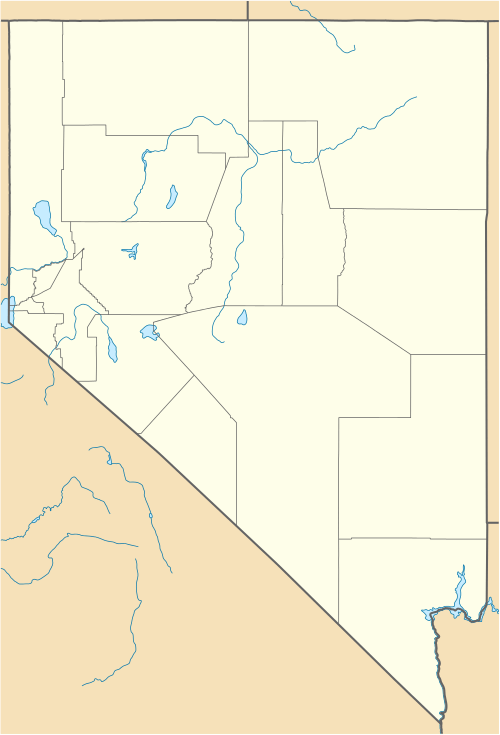 San Jacinto  San Jacinto Location within the state of Nevada | |
| Coordinates: 41°52′07″N 114°40′35″W / 41.86861°N 114.67639°WCoordinates: 41°52′07″N 114°40′35″W / 41.86861°N 114.67639°W | |
| Country | United States |
| State | Nevada |
| County | Elko |
| Elevation | 5,200 ft (1,600 m) |
| Time zone | Pacific (PST) (UTC-8) |
| • Summer (DST) | PDT (UTC-7) |
San Jacinto is a ghost town in Elko County, Nevada, United States.[1] It is part of the Elko Micropolitan Statistical Area. The lowest temperature ever recorded in Nevada, −50 °F (−46 °C) was recorded in San Jacinto on January 8, 1937.[2]
Climate
| Climate data for San Jacinto, Nevada | |||||||||||||
|---|---|---|---|---|---|---|---|---|---|---|---|---|---|
| Month | Jan | Feb | Mar | Apr | May | Jun | Jul | Aug | Sep | Oct | Nov | Dec | Year |
| Record high °F (°C) | 65 (18) |
68 (20) |
74 (23) |
85 (29) |
92 (33) |
100 (38) |
104 (40) |
108 (42) |
95 (35) |
90 (32) |
78 (26) |
68 (20) |
108 (42) |
| Average high °F (°C) | 36.5 (2.5) |
41.3 (5.2) |
49.7 (9.8) |
58.6 (14.8) |
66.6 (19.2) |
76.2 (24.6) |
87.4 (30.8) |
84.9 (29.4) |
76.0 (24.4) |
62.8 (17.1) |
49.5 (9.7) |
40.2 (4.6) |
60.81 (16.01) |
| Average low °F (°C) | 11.4 (−11.4) |
16.8 (−8.4) |
22.7 (−5.2) |
28.7 (−1.8) |
34.4 (1.3) |
39.8 (4.3) |
45.4 (7.4) |
41.3 (5.2) |
33.3 (0.7) |
25.9 (−3.4) |
18.3 (−7.6) |
13.6 (−10.2) |
27.63 (−2.42) |
| Record low °F (°C) | −50 (−46) |
−34 (−37) |
−16 (−27) |
−3 (−19) |
11 (−12) |
19 (−7) |
30 (−1) |
21 (−6) |
10 (−12) |
0 (−18) |
−22 (−30) |
−45 (−43) |
−50 (−46) |
| Average precipitation inches (mm) | 0.66 (16.8) |
0.47 (11.9) |
0.59 (15) |
0.93 (23.6) |
1.29 (32.8) |
1.16 (29.5) |
0.51 (13) |
0.48 (12.2) |
0.47 (11.9) |
0.60 (15.2) |
0.62 (15.7) |
0.56 (14.2) |
8.34 (211.8) |
| Average snowfall inches (cm) | 7.1 (18) |
4.5 (11.4) |
3.7 (9.4) |
2.8 (7.1) |
1.3 (3.3) |
0.2 (0.5) |
0.0 (0) |
0.0 (0) |
0.3 (0.8) |
0.7 (1.8) |
3.1 (7.9) |
5.3 (13.5) |
28.9 (73.4) |
| Source: WRCC[3] | |||||||||||||
References
- ↑ "San Jacinto, Nevada". Geographic Names Information System. United States Geological Survey.
- ↑ National Climatic Data Center. "State Climate Extremes Committee (SCEC)". Retrieved March 22, 2015.
- ↑ "SAN JACINTO, NEVADA (267284)". Desert Research Institute. Retrieved June 12, 2016.
External links
| Wikimedia Commons has media related to San Jacinto, Nevada. |
Municipalities and communities of Elko County, Nevada, United States | ||
|---|---|---|
| Cities | 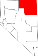 | |
| CDPs | ||
| Other unincorporated communities | ||
| Indian reservation | ||
| Ghost towns | ||
This article is issued from Wikipedia - version of the 8/3/2016. The text is available under the Creative Commons Attribution/Share Alike but additional terms may apply for the media files.