San Francisco Peaks
| San Francisco Peaks | |
|---|---|
|
Dookʼoʼoosłííd (Navajo) Nuvatukya’ovi (Hopi) Wi:mun Kwa (Yavapai) | |
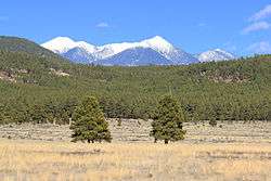
 The San Francisco Peaks viewed from atop nearby 9,000 ft Mount Elden | |
| Highest point | |
| Peak | Humphreys Peak |
| Elevation | 12,633 ft (3,851 m) |
| Coordinates | 35°20′47″N 111°40′40″W / 35.34639°N 111.67778°WCoordinates: 35°20′47″N 111°40′40″W / 35.34639°N 111.67778°W |
| Geography | |
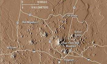 Map of San Francisco Peaks and surrounding volcanic field | |
| Country | United States |
| State | Arizona |
| Geology | |
| Type of rock | Igneous |
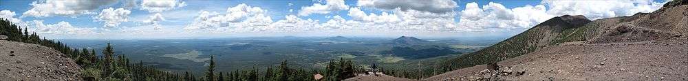
The San Francisco Peaks are a volcanic mountain range in north central Arizona, just north of Flagstaff and a remnant of the former San Francisco Mountain. The highest summit in the range, Humphreys Peak, is the highest point in the state of Arizona at 12,633 feet (3,851 m) in elevation. The San Francisco Peaks are the remains of an eroded stratovolcano.[1] An aquifer within the caldera supplies much of Flagstaff's water while the mountain itself is in the Coconino National Forest, a popular recreation site. The Arizona Snowbowl ski area is on the western slopes of Humphreys Peak, and has been the subject of major controversy involving several tribes and environmental groups.[2][3]
Geography

The six highest individual peaks in Arizona are contained in the range:
- Humphreys Peak, 12,633 feet (3,851 m)
- Agassiz Peak, 12,356 feet (3,766 m)
- Fremont Peak, 11,969 feet (3,648 m)
- Aubineau Peak, 11,838 feet (3,608 m)
- Rees Peak, 11,474 feet (3,497 m)
- Doyle Peak, 11,460 feet (3,493 m)
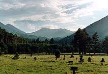
The mountain provides a number of recreational opportunities, including wintertime snow skiing and hiking the rest of the year. Hart Prairie is a popular hiking area and Nature Conservancy preserve located below the mountain's ski resort, Arizona Snowbowl.
Humphreys Peak (latitude 35°20'47" N) and Agassiz Peak (latitude 35°19'33" N) are the two farthest south-lying mountain peaks in the contiguous United States which rise to a height of more than 12,000 feet above sea level.
Prior to its collapse due to a lateral eruption to the northeast (around 200,000 years ago) and subsequent glacial erosion, the San Francisco Peaks fully matured elevation is estimated to have been around 16,000 feet.[4]
History
In 1629, 147 years before San Francisco, California, received that name, Spanish friars founded a mission at a Hopi Indian village in honor of St. Francis, 65 miles from the peaks. Seventeenth century Franciscans at Oraibi village gave the name San Francisco to the peaks to honor St. Francis of Assisi, the founder of their order.[5] The mountain man Antoine Leroux visited the San Francisco Peaks in the mid-1850s, and guided several American expeditions exploring and surveying northern Arizona. Leroux guided them to the only reliable spring, one on the western side of the peaks, which was later named Leroux Springs.
Around 1877, John Willard Young, a son of the Mormon leader Brigham Young, claimed the area around Leroux Springs, and he built Fort Moroni, a log stockade, to house railroad tie-cutters for the Atlantic & Pacific Railroad, which was then being built across northern Arizona.[6]
In 1898, U.S. President William McKinley established the San Francisco Mountain Forest Reserve, at the request of Gifford Pinchot, the head of the U.S. Division of Forestry. The local reaction was hostile—citizens of Williams, Arizona, protested and the Williams News editorialized that the reserve "virtually destroys Coconino County."[6] In 1908, the San Francisco Mountain Forest Reserve became a part of the new Coconino National Forest.
In 2002, Arizona Snowbowl, the ski resort on the peaks, proposed a plan to expand and begin snowmaking using reclaimed water made of treated sewage effluent. A coalition of Indian tribes and environmental groups sued the Coconino National Forest, which leases the land to the ski resort, in an attempt to stop the proposed expansion, citing serious impacts to traditional culture, public health, and the environment.[3] In 2011, construction began on a wastewater pipeline to the peaks. In response, there has been an ongoing series of protest actions including demonstrations and lockdowns in which protesters have chained themselves to construction equipment.[7] Notable protesters include Navajo musician Klee Benally, singer/guitarist for the punk rock band Blackfire, who has been arrested for disorderly conduct during his ten years of protests.[8] As of 2012, a federal appeals court ruled in favor of Arizona Snowbowl, and wastewater to snow conversion began in the 2012-2013 ski season.[8]
Ecology
The biologist Clinton Hart Merriam studied these mountains and surrounding areas in 1889, describing a set of six life zones found from the bottom of the Grand Canyon to the summit of the mountains, based on elevation, latitude, and average precipitation. He designated their characteristic flora, as follows:

- Lower Sonoran Zone - Sonoran Desert plants
- Upper Sonoran Zone - pinyon and juniper woodlands
- Transition Zone - ponderosa pine forests
- Canadian Zone - mixed conifer forest
- Hudsonian Zone - spruce-fir or subalpine conifer forest
- Arctic-Alpine Zone - alpine tundra
Merriam considered that these life zones could be extended to cover all the world's vegetation types with the addition of only one more zone, the tropical zone.
The San Francisco Peaks themselves contain four of the six life zones. The four life zones which are found along the slopes of the San Francisco Peaks are listed below along with their approximate elevation ranges, dominant tree species found within each of the four life zones, and average annual precipitation of each life zone:[9]
- Ponderosa pine forests — The elevation of the zone ranges from approximately 6,000 to 8,500 feet (1,800 to 2,600 m). The dominant tree species is the southwestern ponderosa pine (Pinus brachyptera Engel.). Gambel oak (Quercus gambelii) is a common associate of the ponderosa pine at lower elevations in the forest along with New Mexico locust (Robina neomexicana). At higher elevations, associates include southwestern white pine (Pinus strobiformis), Rocky Mountain Douglas-fir, (Pseudotsuga menziesii var. glauca), Rocky Mountain white fir (Abies concolor var. concolor), and quaking aspen (Populus tremuloides). The average annual precipitation in this zone is 18 to 26 inches (460 to 660 mm).
- Mixed conifer forest — The elevation of this zone ranges from approximately 8,000 to 9,500 feet (2,400 to 2,900 m). Species such as Douglas-fir (Pseudotsuga menziesii var. glauca), white fir (Abies concolor), limber pine (Pinus flexilis var. reflexa), blue spruce. (Picea pungens), and less commonly Southwestern white pine (Pinus flexilis) form mixed stands in this community, with Ponderosa pine (Pinus brachyptera Engel.) joining the mix on warmer slopes. The average annual precipitation in the mixed conifer forest is 25 to 30 inches (640 to 760 mm).
- Subalpine conifer forest — The elevation of this zone varies from approximately 9,500 to 11,500 feet (2,900 to 3,500 m) feet. The dominant tree species of this zone are Engelmann spruce (Picea engelmannii subsp. engelmannii), corkbark fir (Abies lasiocarpa var. arizonica), quaking aspen (Populus tremuloides) and the Rocky Mountain bristlecone pine. (Pinus aristata).[10] The average annual precipitation in the subalpine forest is 30 to 40 inches (760 to 1,020 mm).
- Alpine tundra — The San Francisco Peaks are the home of the only alpine tundra environment in Arizona, occupying 1,200 acres (4.9 km2) above 10,600 feet (3,200 m).[11][12] Only a few small herbaceous plants have established themselves in the tundra. One of these species, is the endemic and threatened San Francisco Peaks groundsel (Packera franciscana), which is found nowhere else in the world.[13][14][15] The average annual precipitation in the tundra is 35 to 40 inches (890 to 1,020 mm).
In native culture
The San Francisco Peaks have considerable religious significance to thirteen local American Indian tribes (including the Havasupai, Navajo, Hopi, and Zuni.) In particular, the peaks form the Navajo sacred mountain of the west, called Dook'o'oosłííd. The peaks are associated with the color yellow, and they are said to contain abalone inside, to be secured to the ground with a sunbeam, and to be covered with yellow clouds and evening twilight. They are gendered female.[16]
For the Hopi people, the San Francisco Peaks are associated with the intercardinal direction southwest. They constitute ritually pure sacred spaces, and are used as sources for ceremonial objects.[17]:553-556 The alignment of the sunset from the peaks to Hopi villages on Black Mesa is used to calculate the winter solstice, signifying "the beginning of a new year, with a new planting season and new life."[17] The peaks are seen as the home of the katsinam or kachina spirits, ancestors who have become clouds following their death.[17] Katsinam are invited to Hopi villages to serve as ethical and spiritual guides to the Hopi community from midwinter to midsummer. Aaloosaktukwi or Humphrey's Peak holds particular religious significance and is associated with the deity Aaloosaka, a symbol of the Two-Horn Society, a religious group among the Hopi dating to the occupation of the Awat’ovi village on Antelope Mesa.[17] Depiction of the peaks in association with calendar-keeping is attested in a kiva at the Hisatsinom settlement of Homol'ovi, which was occupied from 1250 to 1425;[17]katsinam imagery dates to the 13th century as well.[17]:556 Other Native American peoples also relate kachina spirits to heavy snowfalls on the peaks.

There are several names for the San Francisco Peaks in local languages:[6]
- Dook'o'oosłííd—(Navajo) ("Dook'o'oosłííd," which means "the summit which never melts" or "the mountain which peak never thaws.")
- Nuva'tukya'ovi—(Hopi) (Nuva'tukya'ovi, which means "place-of-snow-on-the-very-top")
- Dził Tso—Dilzhe’e—(Apache)
- Tsii Bina—Aa'ku—(Acoma)
- Nuvaxatuh—Nuwuvi—(Southern Paiute)
- Hvehasahpatch or Huassapatch—Havasu 'Baaja—(Havasupai)
- Wik'hanbaja—Hwal`bay—(Hualapai)
- Wi:mun Kwa—Yavapai
- Sunha K'hbchu Yalanne—A:shiwi (Zuni)
- 'Amat 'Iikwe Nyava[18]—Hamakhav—(Mojave)
- Sierra sin Agua—(Spanish)
- The Peaks—(Anglo) Arizonans
See also
References
- ↑ "San Francisco Peaks". USGS factsheet. Retrieved 2006-12-16.
- ↑ "San Francisco Peaks, AZ". NASA Earth Observatory. Retrieved 2006-05-23.
- 1 2 Nasaw, Daniel (2011-10-19). "Indians oppose 'recycled' sewage for Arizona skiing". BBC News Magazine. BBC.
- ↑ Hardy, James A. "The History of the San Francisco Peaks" (PDF). Flagstaff Visitor Center.
- ↑ Cline, Platt (1976). They Came to the Mountain. Flagstaff: Northern Arizona University with Old Town Press.
- 1 2 3 Houk, Rose (2003). "San Francisco Peaks". The Mountains Know Arizona. Arizona Highways Books.
- ↑ MacMillan, Leslie (August 19, 2013). "Diné activist protests wastewater-to-snow scheme". High Country News.
- 1 2 MacMillan, Leslie (September 26, 2012). "Resort's Snow Won't Be Pure This Year; It'll Be Sewage". New York Times.
- ↑ "Biotic Communities of the Colorado Plateau". Northern Arizona University and United States Geological Survey. Retrieved March 21, 2012.
- ↑ "Alpine Tundra" (PDF). Coconino National Forest Plan Revision. United States Forest Service. Retrieved 2012-03-21.
- ↑ "Species Biology And Population Trend" (PDF). Arizona Game and Fish Department. Retrieved 2012-03-21.
- ↑ "Alpine Tundra Biome". Northern Arizona University. Retrieved 2012-03-21.
- ↑ Epple, Anne Orth; Epple, Lewis E. (1995). A Field Guide to the Plants of Arizona. Falcon Publishing.
- ↑ "Alpine Tundra". Arizona Game and Fish Department. Retrieved 2006-09-09.
- ↑ "Kachina Peaks Wilderness". GORP.
- ↑ Robert S. McPherson, Sacred Land, Sacred View: Navajo perceptions of the Four Corners Region, Brigham Young University, ISBN 1-56085-008-6.
- 1 2 3 4 5 6 Glowacka, Maria; Dorothy Washburn; Justin Richland (2009). "Nuvatukya'ovi, San Francisco Peaks". Current Anthropology. 50 (4). doi:10.1086/599069. ISSN 0011-3204.
- ↑ Munro, P et al. A Mojave Dictionary Los Angeles: UCLA, 1992
Further reading
- Duffield, Wendell A., 1998, Volcanoes of Northern Arizona, Flagstaff, Grand Canyon Association. ISBN 0-938216-58-9. Reviews

External links
| Wikimedia Commons has media related to San Francisco Peaks. |
- Shaded relief map of the Peaks, showing locations of the principal peaks
- San Francisco Peaks at Coconino National Forest
- San Francisco Peak Trails at HikeArizona.COM
- Live webcam of the San Francisco Peaks
- Hart Prairie Preserve at Nature Conservancy