San Francisco, Cebu
| San Francisco | |
|---|---|
| Municipality | |
|
Mangodlong Rock Beach Resort | |
 Map of Cebu with San Francisco highlighted | |
.svg.png) San Francisco Location within the Philippines | |
| Coordinates: 10°39′N 124°21′E / 10.65°N 124.35°ECoordinates: 10°39′N 124°21′E / 10.65°N 124.35°E | |
| Country | Philippines |
| Region | Central Visayas (Region VII) |
| Province | Cebu |
| District | 5th district of Cebu |
| Barangay | 15 (see § Barangays) |
| Government [1] | |
| • Type | Sangguniang Bayan |
| • Mayor | Aly Arquillano (BAKUD) |
| • Vice mayor | Allan Arquillano |
| • Town Council |
Members
|
| • Representative | Red Durano |
| Area[2] | |
| • Total | 106.93 km2 (41.29 sq mi) |
| • Water | 6.80 km2 (2.63 sq mi) |
| Population (2015 census)[3] | |
| • Total | 55,180 |
| • Density | 520/km2 (1,300/sq mi) |
| • Voter (2016)[4] | 27,484 |
| Time zone | PHT (UTC+8) |
| ZIP code | 6050 |
| IDD : area code | +63 (0)32 |
| Income class | 3rd class |
| PSGC | 072242000 |

San Francisco is a 3rd municipal income class municipality on Camotes Islands in the province of Cebu, Philippines.[2] According to the 2015 census, it has a population of 55,180.[3] In the 2016 election, it had 27,484 registered voters.[4]
Geography
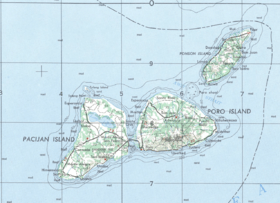
San Francisco consists primarily of Pacijan Island (also known as Pajican Island[5]), as well as the tiny Tulang islet just north of Pacijan. Both islands are part of the Camotes Islands group in the Camotes Sea (that also includes Poro Island and Ponson Island). They are located east of the main island of Cebu, south and west of Leyte and north of Bohol.
Pacijan Island is about 14.75 kilometres (9.17 mi) long and 8.5 kilometres (5.3 mi) wide. A 1,400-metre (1,500 yd) causeway crosses the mangrove swamp to connect Pacijan and Poro Island. It was constructed during the Spanish era, to bridge the islands for easier trading and attending services in Poro church.
Barangays
San Francisco comprises 15 barangays:[2]
| PSGC | Barangay | Population | ±% p.a. | ||
|---|---|---|---|---|---|
| 2015[3] | 2010[6] | ||||
| 072242002 | Cabunga‑an | 4.0% | 2,226 | 1,764 | +4.53% |
| 072242003 | Campo | 5.7% | 3,123 | 2,517 | +4.19% |
| 072242004 | Consuelo | 10.4% | 5,750 | 4,827 | +3.39% |
| 072242006 | Esperanza | 11.5% | 6,370 | 5,629 | +2.38% |
| 072242007 | Himensulan | 4.2% | 2,331 | 2,169 | +1.38% |
| 072242001 | Montealegre | 3.1% | 1,735 | 1,288 | +5.84% |
| 072242008 | Northern Poblacion | 8.7% | 4,786 | 3,779 | +4.60% |
| 072242009 | San Isidro | 7.9% | 4,346 | 3,668 | +3.28% |
| 072242010 | Santa Cruz | 9.9% | 5,465 | 4,717 | +2.84% |
| 072242011 | Santiago | 4.4% | 2,412 | 2,132 | +2.38% |
| 072242012 | Sonog | 6.9% | 3,799 | 3,366 | +2.33% |
| 072242013 | Southern Poblacion | 7.5% | 4,143 | 3,453 | +3.53% |
| 072242014 | Unidos | 1.8% | 992 | 1,035 | −0.80% |
| 072242015 | Union | 9.1% | 5,023 | 4,721 | +1.19% |
| 072242016 | Western Poblacion | 4.9% | 2,679 | 2,292 | +3.02% |
| Total | 55,180 | 47,357 | +2.95% | ||
Demographics
| Population census of San Francisco | |||||||||||||||||||||||||
|---|---|---|---|---|---|---|---|---|---|---|---|---|---|---|---|---|---|---|---|---|---|---|---|---|---|
|
| ||||||||||||||||||||||||
| Source: Philippine Statistics Office[3][6][7] | |||||||||||||||||||||||||
In the 2016 election, it had 27,484 registered voters, meaning that 50% of the population are aged 18 and over.[4]
Tulang islet
Tulang island (known locally as Tulang Diot) is a five-minute boat ride from Tulang Dako on the main island of Pacijan. Both Tulang Diot and Tulang Dako are part of barangay Esperanza. The islet is almost entirely covered with coconut palms and measures about 1.6 by 0.6 kilometres (1.0 by 0.4 mi): the residential area is confined to a small triangle at the southern end. Total area about 40 ha (100 acres), of which only 3.5 ha (8.6 acres) (8.8%) is inhabited.
Protohistory
Carl Guthe, director of the University of Michigan Anthropological Museum, during his 1923-25 collecting trip and explorations of archaeological sites in the Philippines,[8] conducted an archeological dig in a cave site on Tulang. Located on the southeastern coast of the island, the cave measures about 3.7 by 2.7 metres (12 by 9 feet). Guthe reported it to contain bone fragments and teeth of about 60 individuals. Associated grave goods included earthenware pottery, shell bracelets, bronze and iron artefacts (iron tang, bronze chisel, iron blade), glass and stone beads, hammerstone and pestle. Filed teeth were also recovered from this site.[lower-alpha 1]
21st century
Just before Typhoon Yolanda struck in November 2013, the mayor of San Francisco ordered the evacuation of all the residents (approximately 1,000) to the main island. This was credited with saving their lives as all houses on the island (about 500) were completely destroyed.[9]
Attractions
| Sights | |||
| 1 | Lake Danao | 2 | Tumibo Cave |
| 3 | Arqui's Viewing Deck | ||
| Beaches | |||
| 4 | Bakhaw Beach | 5 | Mangodlong Beach |
| 6 | Santiago Bay | ||
Lake Danao
1 Lake Danao is a freshwater lake located in the northern part of Pacijan Island, about 4.9 kilometres (3.0 mi) long and 1.8 kilometres (1.1 mi) wide, with an elevation of 5 metres (16 ft) above sea level. Its area of 680 ha (1,700 acres) makes it the largest lake not only in the province but also in the Visayas regions. It has two interior islands which can be reached by paddleboat or as part of the scenic lake cruise. An 18-kilometre (11 mi) hiking and cycling trail encircles the entire perimeter of the lake. Although classifies as "freshwater", that doesn't necessarily make it suitable for irrigation. A 2015 study determined which crops could be sustained.[10]
- Flora
- Corn and coconut grow all over the island, including the areas surrounding the lake. Several rare orchids and a variety of herbs of medicinal value grow along the lake shore.
- Most of the original vegetation has disappeared, and even the small islets in the lake have been planted with coconut palms. The only remaining area of aquatic vegetation is on the east side of the lake, where the water is shallow and there is a dense growth of submerged vegetation, including water cabbage, hydrilla and water hyacinth.
- Soli-soli is a type of grass that grows abundantly along the banks of the lake and is one source of livelihood on the island. These grasses are harvested, dried and woven into different kinds of handicrafts such as bags, mats, hats and other decorative items, and then sold to local and mainland market outlets. An annual festival is held nominally celebrating the plant. This takes place every third Sunday of March, coinciding with the fiesta honoring Saint Joseph. Extending throughout the island, the event is an occupational festival injected with religious sentiments shown through flamboyant colors, abundant food and fervent dancing.
- Fauna
- The lake supports a very rich fishery, and many local residents depend on this resource for their subsistence.
- The rich ichthyofauna includes
- tilapia
- common carp (Cyprinus carpio)
- milkfish (Chanos chanos)
- tank goby (Glossogobius giuris)
- catfish (Clarias sp.)
- A wide variety of avifauna occur including
- little grebe (Tachybaptus ruficollis)
- intermediate egret (Egretta intermedia)
- purple heron (Ardea purpurea)
- wandering whistling duck (Dendrocygna arcuata)
- The estuarine crocodile (Crocodylus porosus) formerly inhabited the lake: according to the Groombridge report (1982),[11] the population was still healthy in 1978, but according to other reports, the last individual was killed in 1971. Monitor lizards (Varanus) can still be seen occasionally on its shore.[12]
Other sights
2 Tumibo Cave is a grotto in the Tumibo plateau in Sonog, which offers swimming in a crystal-clear underground pool.
3 Arqui's Viewing Deck in the summit area of Monte Alegre offers outstanding picturesque views across Pacijan including Lake Danao and Tulang, as well as the islands of Cebu and Leyte beyond.
4 Bakhaw Beach is located in Esperanza. Its sugary sand and clear waters make it safe for children.
5 Mangodlong Beach is one of the most visited beaches in the Camotes. It offers white sand and is located in the fishing village of Mangodlong in Himensulan. Across the beach is a coral islet.
6 Santiago Bay is located in the southwestern part of the island. The wide and deep white sand beach is situated directly in front of the town of Santiago. This beach is owned by the local government and is a favorite rendezvous for locals and visitors.
Notes
- ↑ Carl Guthe explored 485 sites comprising 120 caves, 134 burial grounds and 231 graves all over the Philippines that are contained in an inventory report now deposited at the University of Michigan.
References
- ↑ "Municipality". Quezon City, Philippines: Department of the Interior and Local Government. Retrieved 31 May 2013.
- 1 2 3 "Municipal: San Francisco, Cebu". PSGC Interactive. Quezon City, Philippines: Philippine Statistics Authority. Retrieved 8 January 2016.
- 1 2 3 4 "Region VII (CENTRAL VISAYAS)". Census of Population (2015): Total Population by Province, City, Municipality and Barangay (Report). PSA. Retrieved 20 June 2016.
- 1 2 3 "2016 National and Local Elections Statistics". Commission on Elections. 2016.
- ↑ Famous Destinations - Camotes group of islands, Cebu Province Official Website. Retrieved on 2010-06-23.
- 1 2 "Region VII (CENTRAL VISAYAS)". Census of Population and Housing (2010): Total Population by Province, City, Municipality and Barangay (Report). NSO. Retrieved 29 June 2016.
- ↑ "Region VII (CENTRAL VISAYAS)". Census of Population (1995, 2000 and 2007): Total Population by Province, City and Municipality (Report). NSO. Archived from the original on 24 June 2011.
- ↑ Guthe 1927.
- ↑ McElroy 2013.
- ↑ Alkuino 2015.
- ↑ Groombridge & Wright 1982.
- ↑ Magsalay 2010.
Sources
- Alkuino, Xerxes (8 March 2015). "Lake water is suitable for crops". Cebu Provincial Government. Archived from the original on 2 April 2015. Retrieved 18 March 2015.
- Groombridge, B. & Wright, L., eds. (1982). The IUCN Amphibia–reptilia Red Data Book. International Union for Conservation of Nature and Natural Resources. Species Survival Commission. ISBN 9782880326012.
- Guthe, Carl E. (1927). "THE UNIVERSITY OF MICHIGAN PHILIPPINE EXPEDITION". American Anthropologist. University of Michigan / Blackwell Publishing Ltd. 29 (1): 69–76. doi:10.1525/aa.1927.29.1.02a00040. ISSN 1548-1433.
- Magsalay, Perla M. (2010). "PHILIPPINES INTRODUCTION - Ramsar Sites Information Service" (pdf). Haribon Foundation. ASEAN Centre for Biodiversity. pp. 36–37. Retrieved 13 November 2014.
- McElroy, Andy (15 November 2013). "Evacuation saves whole island from Typhoon Haiyan". United Nations Office for Disaster Risk Reduction. Retrieved 8 November 2014.
 |
Camotes Sea | | ||
| Camotes Sea | |
Poro | ||
| ||||
| | ||||
| Camotes Sea |
Cebu City (capital) | |
| Municipalities |
|
| Component cities | |
| Highly urbanized cities | (Administratively independent from the province but grouped under Cebu by the Philippine Statistics Authority. Mandaue is grouped under the 6th legislative district of Cebu but still independent from the province.) |