San Augustine, Texas
| San Augustine, Texas | |
|---|---|
| City | |
|
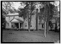
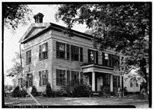
Hail Blount House | |
 Location of San Augustine, Texas | |
 | |
| Coordinates: 31°31′52″N 94°6′39″W / 31.53111°N 94.11083°WCoordinates: 31°31′52″N 94°6′39″W / 31.53111°N 94.11083°W | |
| Country | United States |
| State | Texas |
| County | San Augustine |
| Area | |
| • Total | 4.8 sq mi (12.5 km2) |
| • Land | 4.7 sq mi (12.2 km2) |
| • Water | 0.1 sq mi (0.3 km2) |
| Elevation | 371 ft (113 m) |
| Population (2000) | |
| • Total | 2,475 |
| • Density | 525.2/sq mi (202.8/km2) |
| Time zone | Central (CST) (UTC-6) |
| • Summer (DST) | CDT (UTC-5) |
| ZIP code | 75972 |
| Area code(s) | 936 |
| FIPS code | 48-65024[1] |
| GNIS feature ID | 1383177[2] |
| Website | San Augustine, Texas |
San Augustine is the county seat city of San Augustine County, Texas,[3] in East Texas, United States. The population was 2,108 at the 2010 census.
History
The first European settlement in the area began in 1717 with the establishment of Mission Nuestra Señora de los Dolores de los Ais by Spanish Missionaries. The mission was abandoned and reestablished in 1721. It lasted until 1773 and is now preserved as Mission Dolores State Historic Site
The town began in 1832 with land owned by Thomas S. McFarland. The town was named after the Presidio de San Agustín de Ahumada, which had been named in honor of the (1755–1760) Viceroy of New Spain, Don Agustín de Ahumada y Villalón.[4]
Geography
San Augustine is located at 31°31′52″N 94°06′39″W / 31.531086°N 94.110971°W (31.531086, −94.110971).[5]
According to the United States Census Bureau, the city has a total area of 4.8 square miles (12 km2), of which 4.7 square miles (12 km2) is land and 0.1 square miles (0.26 km2) (2.08%) is water.
Climate
The climate in this area is characterized by hot, humid summers and generally mild to cool winters. According to the Köppen Climate Classification system, San Augustine has a humid subtropical climate, abbreviated "Cfa" on climate maps.[6]
Demographics
| Historical population | |||
|---|---|---|---|
| Census | Pop. | %± | |
| 1870 | 250 | — | |
| 1880 | 503 | 101.2% | |
| 1890 | 744 | 47.9% | |
| 1900 | 261 | −64.9% | |
| 1910 | 1,204 | 361.3% | |
| 1920 | 1,268 | 5.3% | |
| 1930 | 1,247 | −1.7% | |
| 1940 | 1,516 | 21.6% | |
| 1950 | 2,510 | 65.6% | |
| 1960 | 2,584 | 2.9% | |
| 1970 | 2,539 | −1.7% | |
| 1980 | 2,930 | 15.4% | |
| 1990 | 2,337 | −20.2% | |
| 2000 | 2,475 | 5.9% | |
| 2010 | 2,108 | −14.8% | |
| Est. 2015 | 2,009 | [7] | −4.7% |
As of the census[1] of 2000, there were 2,475 people, 859 households, and 573 families residing in the city. The population density was 525.2 people per square mile (202.9/km2). There were 1,076 housing units at an average density of 228.3/sq mi (88.2/km2). The racial makeup of the city was 37.82% White, 57.94% African American, 0.08% Native American, 0.69% Asian, 3.07% from other races, and 0.40% from two or more races. Hispanic or Latino of any race were 5.13% of the population.
There were 859 households out of which 29.8% had children under the age of 18 living with them, 37.3% were married couples living together, 26.0% had a female householder with no husband present, and 33.2% were non-families. 30.5% of all households were made up of individuals and 17.0% had someone living alone who was 65 years of age or older. The average household size was 2.57 and the average family size was 3.23.
In the city the population was spread out with 26.9% under the age of 18, 8.1% from 18 to 24, 22.6% from 25 to 44, 19.7% from 45 to 64, and 22.7% who were 65 years of age or older. The median age was 38 years. For every 100 females there were 80.4 males. For every 100 females age 18 and over, there were 67.6 males.
The median income for a household in the city was $25,489, and the median income for a family was $33,203. Males had a median income of $23,750 versus $17,628 for females. The per capita income for the city was $14,918. About 19.1% of families and 24.7% of the population were below the poverty line, including 35.0% of those under age 18 and 30.7% of those age 65 or over.
Education
The city of San Augustine is served by the San Augustine Independent School District.
Notable people
- Kenneth Lewis Anderson – The last Vice President of the Republic of Texas
- Joseph Barton Elam – U.S. Representative from Louisiana's 4th congressional district from 1877 to 1881; spent part of his childhood near San Augustine
- Sam Houston – First President of the Republic of Texas
- Kenneth M. Hoyt – U.S. District Judge
- Memucan Hunt, Jr. – Secretary of the Navy of the Republic of Texas and Texas' Minister to the United States
- Frances Cox Henderson – wife of Governor Henderson, helped establish Episcopal Church in San Augustine
- Governor J. Pinckney Henderson – The first governor of the State of Texas
- Governor Oran M. Roberts
- Texas Lieutenant Governor John A. Greer
- Texas Lieutenant Governor Ben Ramsey
- John A Ramsey – prominent libertarian entrepreneur and philanthropist. (Nephew to Ben Ramsey)
- Edward A. Clark – U.S. Ambassador to Australia
- Dominique Edison – Seattle Seahawks wide receiver
- John William "Bill" Davis – businessman and entrepreneur who received the Horatio Alger Award and was a member of the Beverage World Hall of Fame[9]
References
- 1 2 "American FactFinder". United States Census Bureau. Retrieved 2008-01-31.
- ↑ "US Board on Geographic Names". United States Geological Survey. 2007-10-25. Retrieved 2008-01-31.
- ↑ "Find a County". National Association of Counties. Retrieved 2011-06-07.
- ↑ "City of San Augustine, Texas". City of San Augustine, Texas. Retrieved August 4, 2012.
- ↑ "US Gazetteer files: 2010, 2000, and 1990". United States Census Bureau. 2011-02-12. Retrieved 2011-04-23.
- ↑ Climate Summary for San Augustine, Texas
- ↑ "Annual Estimates of the Resident Population for Incorporated Places: April 1, 2010 to July 1, 2015". Retrieved July 2, 2016.
- ↑ "Census of Population and Housing". Census.gov. Retrieved June 4, 2015.
- ↑ Horatio Alger Association of Distinguished Americans http://www.horatioalger.com/member_info.cfm?memberid=dav90
External links
Municipalities and communities of San Augustine County, Texas, United States | ||
|---|---|---|
| City |  | |
| Town | ||
| Unincorporated communities | ||
