San Antonio River Walk
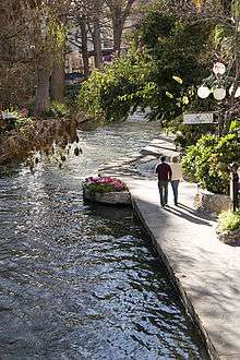
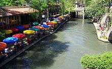
The San Antonio River Walk (also known as Paseo del Río or simply as the River Walk) is a network of walkways along the banks of the San Antonio River, one story beneath the streets of San Antonio, Texas, USA. Lined by bars, shops, restaurants, nature, and public art the River Walk is an important part of the city's urban fabric and a tourist attraction in its own right.
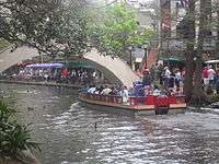
Today, the River Walk is a successful special-case pedestrian street, one level down from the automobile street. The River Walk winds and loops under bridges as two parallel sidewalks lined with restaurants and shops, connecting the major tourist draws from the Shops at Rivercenter, to the Arneson River Theatre, to Marriage Island, to La Villita, to HemisFair Park, to the Tower Life Building, to the San Antonio Museum of Art, to the Pearl and the city's five Spanish colonial missions, which have just been named a World Heritage Site, including the Alamo. During the annual springtime Fiesta San Antonio, the River Parade features flowery floats that float down the river.
History
In September 1921, a disastrous flood along the San Antonio River took 50 lives.[1] Plans were then developed for flood control of the river. Among the plans was to build an upstream dam (Olmos Dam) and bypass a prominent bend of the river in the Downtown area (between present day Houston Street and Villita Parkway), then to pave over the bend, and create a storm sewer.
Work began on the Olmos Dam and bypass channel in 1926; however, the San Antonio Conservation Society successfully protested the paved sewer option. No major plans came into play until 1929, when San Antonio native and architect Robert Hugman submitted his plans for what would become the River Walk. Although many have been involved in development of the site, the leadership of former mayor Jack White was instrumental in passage of a bond issue that raised funds to empower the 1938 “San Antonio River Beautification Project”, which began the evolution of the site into the present 2.5-mile-long River Walk.
Hugman endorsed the bypass channel idea (which would be completed later that year) but, instead of paving over the bend, Hugman suggested 1) a flood gate at the northern (upstream) end of the bend; 2) a small dam at the southern (downstream) end of the bend; and 3) a Tainter gate in the channel to regulate flow. The bend would then be surrounded by commercial development, which he titled "The Shops of Aragon and Romula". Hugman went as far as to maintain his architect's office along the bend.
Hugman's plan was initially not well-received – the area was noted for being dangerous. At one point, it was declared off-limits to military personnel. People were warned of the threat of being "drowned like a rat" should the river flood. However, over the next decade support for commercial development of the river bend grew, and crucial funding came in 1939 under the WPA which resulted in the initial construction of a network of some 17,000 feet (5,200 m) of walkways, about twenty bridges, and extensive plantings including some of the bald cypress (others are several hundred years old) whose branches stretch up to ten stories and are visible from street level.
Hugman's persistence paid off; he was named project architect. His plan would be put to the test in 1946, when another major flood threatened Downtown San Antonio, but the Olmos Dam and bypass channel minimized the area damage. Casa Rio, a landmark River Walk restaurant, became the first restaurant in the area in 1946, opening next door to Hugman's office.
_IMG_7600.JPG)
Through the following decades the network has been improved and extended. The first major extension of the Riverwalk was constructed by the joint venture of two general contractors Darragh & Lyda Inc. and H. A. Lott Inc. to Tower of the Americas as part of HemisFair '68. The expansion extended the Riverwalk beyond its natural banks at the horseshoe bend to the new convention center and theater by excavating much of the block bordered by Commerce, Bowie, Market and Alamo Streets. That was also the year the Hilton Palacio del Rio was built, the first of many downtown hotels that leverage their slice of urban "riverfront." A subsequent major expansion opened in 1988 that extended a branch from the 1968 extension to create a lagoon at the new Rivercenter Mall and Marriott Rivercenter Hotel.
In 1981 the Hyatt Regency San Antonio opened with a new pedestrian connector that linked Alamo Plaza to the River Walk with concrete waterfalls, waterways and indigenous landscaping. Known as the Paseo del Alamo, this river "extension" actually flows from Alamo Plaza into the San Antonio River through the atrium of the hotel. This connector not only allows the hotel to market itself as being on Alamo Plaza and on the River Walk, but it provides the city with an urban park that connects the city's two largest tourist attractions.
Many downtown buildings like the Casino Club Building have street entrances and separate river entrances one level below. This separates the automotive service grid (for delivery and emergency vehicles) and pedestrian traffic below, and creating an intricate network of bridges, walkways, and old staircases. The San Antonio Spurs had their five NBA Championship victory parades/cruises along the river.
Growth and expansion
Expansion plans are planned for areas of the river north and south of Downtown. As chain restaurants and establishments have begun to flourish, now taking up about a third of commercial space, talk has begun at City Hall about limiting their existence on the River Walk and keeping a distinctively local flair. On May 30, 2009 the city opened the $72 million Museum Reach.[2] The Museum Reach features local attractions such as the San Antonio Museum of Art and The Pearl Brewery, which has become one of the most popular areas for locals.[3][4]
Two years later, in May 2011, the River Walk was extended by several miles to extend from Downtown to Mission Espada which is on the city's south side. This addition (named the "Mission Reach") is notable for its emphasis on ecological controls and improvements, as well as trail improvements to support both hiking and biking.[5] The Mission Reach recently opened up paddling trails [6] and the biking trails allow tourists to experience the UNESCO World Heritage Missions.[7][8]
The River Walk has inspired similar projects in other cities, such as the Little Sugar Creek Greenway in Charlotte, North Carolina,[9] the Cherry Creek Greenway in Denver, Colorado,[10] and the Santa Lucía Riverwalk in Monterrey, Mexico.[11]
After years of murmuring from locals and tourists about the water's quality, talk has also begun about cleaning up the water, although the muddy bottom and silt deposits make this difficult.[12] The muddy bottom does receive an annual cleaning during the Mud Festival.[13]
In early 2016, for the first time in its history, the River Walk was connected with another linear urban walkway, the San Pedro Creek Greenway. The greenway joins with the River Walk at the confluence of the San Pedro Creek and the San Antonio River near Mission Concepción.
See also
References
- ↑ Inside the Gates, Daughters of the Republic of Texas Library: San Antonio Flood of 1921. Drtlibrary.wordpress.com (2010-09-24). Retrieved on 2013-05-04.
- ↑ San Antonio River Authority: Museum Reach. Sanantonioriver.org (2009-05-30). Retrieved on 2013-05-04.
- ↑ http://www.startribune.com/san-antonio-s-pearl-district-a-gem-of-a-hood/257613471/
- ↑ http://www.lavernianews.com/article.php?id=1839&n=featured-column-river-walks-museum-reach-offers-art-food-fun
- ↑ San Antonio River Authority: Mission Reach Ecosystem Restoration and Recreation Project. Sanantonioriver.org. Retrieved on 2013-05-04.
- ↑ http://www.missionkayak.com
- ↑ http://www.missionbiketour.com
- ↑ http://whc.unesco.org/en/list/1466
- ↑ Washburn, Mark. (2012-04-27) Take a walk on the artsy, wild side of the greenway. Charlotte Observer. Retrieved on 2013-05-04.
- ↑ Searns, Robert (2007-03-16) River walk to creekfront: Community perseverance pays off. American Trails Magazine. Retrieved on 2013-05-04.
- ↑ Luis Xavier Rangel-Ortiz (2008). Sociocultural Identity and Self Conceptualizations of Mexican Transnational Entrepreneurs (MTNE) in San Antonio, Texas. ProQuest. p. 5. ISBN 978-0-549-67593-8.
- ↑ River Walk Drained; Mud Party To Follow KSAT News, San Antonio, Texas (2009-01-06).
- ↑ Texas Travel: San Antonio's Riverwalk Mud Festival. Gotexas.about.com (2012-04-09). Retrieved on 2013-05-04.
External links
| Wikimedia Commons has media related to San Antonio River Walk. |
- San Antonio River Improvements Projects — Website run by the San Antonio River Authority covering current and future projects along the River Walk
- The World Famous San Antonio River Walk — business/tourist online guide
- River Walk — San Antonio Convention and Visitors Bureau
- Historic American Landscapes Survey (HALS) No. TX-1, "San Antonio River Walk, 418 Villita Street, San Antonio, Bexar County, TX", 6 measured drawings
Coordinates: 29°25′31″N 98°29′30″W / 29.425205°N 98.491575°W