Samara Bend
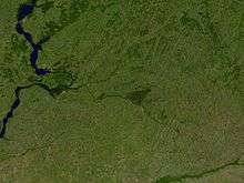
Samara Bend and Samara River from space.
The Samara bend (Russian: Самарская Лука) is a large hairpin bend of the middle Volga River at the confluence of the Samara River (53°07′N 50°04′E / 53.117°N 50.067°ECoordinates: 53°07′N 50°04′E / 53.117°N 50.067°E). It is situated in Samara Oblast, Volga Federal District of Russia.
As the Volga enters its middle course it reaches the Zhiguli Mountains, and the Samara Bend is formed as the river circles these mountains.[1]
See also
| Wikimedia Commons has media related to Samara Bend. |
References
- ↑ "Samara Bend". Russian Geographical Society. 10 May 2011. Retrieved 10 December 2013.
This article is issued from Wikipedia - version of the 12/10/2013. The text is available under the Creative Commons Attribution/Share Alike but additional terms may apply for the media files.