Salisbury and Southampton Canal
| Salisbury and Southampton Canal | |
|---|---|
|
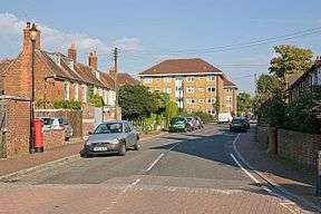
The presence of the canal bed, which ran left to right, caused problems during the construction of Clover Nook, seven blocks of flats built on Old Redbridge Road. The nearest block is numbers 81 to 96. | |
| Specifications | |
| Maximum boat length | 60 ft 0 in (18.29 m) |
| Maximum boat beam | 8 ft 0 in (2.44 m) |
| Locks | 16 or 17 |
| Status | Mainly destroyed |
| History | |
| Original owner | Proprietors of the Salisbury and Southampton Canal |
| Principal engineer | John Rennie |
| Date of act | 1795 |
| Date of first use | 1802 |
| Date closed | 1808 |
| Geography | |
| Start point | Salisbury |
| End point | Southampton |
| Connects to | Andover Canal, River Test, River Itchen |
| Salisbury and Southampton Canal | |||||||||||||||||||||||||||||||||||||||||||||||||||||||||||||||||||||||||||||||||||||||||||||||||||||||||||||||||||||||||||||||||||||||||||||||||||||||||||||||||||||||||||||||||||
|---|---|---|---|---|---|---|---|---|---|---|---|---|---|---|---|---|---|---|---|---|---|---|---|---|---|---|---|---|---|---|---|---|---|---|---|---|---|---|---|---|---|---|---|---|---|---|---|---|---|---|---|---|---|---|---|---|---|---|---|---|---|---|---|---|---|---|---|---|---|---|---|---|---|---|---|---|---|---|---|---|---|---|---|---|---|---|---|---|---|---|---|---|---|---|---|---|---|---|---|---|---|---|---|---|---|---|---|---|---|---|---|---|---|---|---|---|---|---|---|---|---|---|---|---|---|---|---|---|---|---|---|---|---|---|---|---|---|---|---|---|---|---|---|---|---|---|---|---|---|---|---|---|---|---|---|---|---|---|---|---|---|---|---|---|---|---|---|---|---|---|---|---|---|---|---|---|---|---|---|
Legend
| |||||||||||||||||||||||||||||||||||||||||||||||||||||||||||||||||||||||||||||||||||||||||||||||||||||||||||||||||||||||||||||||||||||||||||||||||||||||||||||||||||||||||||||||||||
The Salisbury and Southampton Canal was intended to be a 13-mile long canal in southern England from Redbridge, now a western suburb of Southampton at the head of Southampton Water, to Salisbury connecting with the Andover Canal at a junction near Mottisfont. Another section, through Southampton, was to connect via a tunnel to the River Itchen.
History
The idea of a canal from Salisbury to Redbridge was announced in 1768, after the canal engineer James Brindley had made a survey of a possible route. Two years later, Robert Whitworth was working on plans for a canal from Andover to Redbridge, and the Salisbury Committee wanted Brindley to survey an amended route that would join Whitworth's Canal at Kimbridge. Brindley was too busy and so sent one of his assistants, but the scheme foundered in 1772 when the Andover bill was not presented to Parliament.[1]
The route was surveyed in 1793 and authorised by an Act of Parliament in 1795.[2] The proprietors appointed Joseph Hill as the surveyor, who estimated that the project would cost around £50,000. Although the canal had initially attracted strong support from merchants in Bristol, who saw it as part of a link between Bristol and Southampton, many of the shareholders did not respond to the calls for money, and so the company was always short of working capital. The job of constructing the tunnel in Southampton was given to Thomas Jenkins, but the work did not go well, and John Rennie was asked to inspect it. His report highlighted serious deficiencies with the work.[3]
Hill resigned from the project shortly afterwards. A new Act of Parliament was obtained in 1800, which authorised the raising of additional capital, but although the company found it difficult to obtain extra shareholders, they appointed George Jones as the resident engineer, and some progress was made. By January 1803, the canal was in use from the west end of the tunnel to Redbridge, where it joined the Andover Canal, and from Kimbridge, further north on the Andover Canal, to West Grimstead, 4 miles (6.4 km) to the east of Salisbury. The company struggled to find the money to continue construction, and sheriffs seized parts of the canal after Jones sued the company for failing to pay his salary and won the court action.[3]
Tolls were collected until at least the end of 1804, and the canal was still being used for some months after that, but a lack of maintenance and some wilful damage resulted in the canal being closed in 1806. The company was defunct by 1808. Parts of the Salisbury arm soon became dry, and others became a small stream, but the section in Southampton became a stagnant ditch. In 1841 a woman drowned in the canal, after which the council took action and filled it in.[4] Raising money and getting the legal powers to fill canal in delayed work until 1846 and the final grassing over didn't take place until 1851.[4]
Although much of this section was re-used by the Southampton and Dorchester Railway when it was constructed, plans to re-use the tunnel were abandoned when it was found to be unsuitable, and a new tunnel was excavated.[5]
Route
Southampton branch
Very little remains of the Southampton Branch of the canal, and in 1966 Edwin Welch produced a small book for the Southampton Records Office, the research for which included the production of annotated maps, based on 2.5-inch Ordnance Survey maps from the 1930s, to document the route. Development was rapidly obliterating what few remains there were even then.[6] The branch from the Test started close to God's House Tower, which at the time was on the bank of the river. This area has changed a great deal, with reclamation of land for the ferry terminal.[7] From there it headed due north. The street names of Canal Walk and Lower Canal Walk give some clues to the route, but the canal was filled in haphazardly in the middle of the nineteenth century, and was then built over. The street plans were altered significantly after the Second World War, when Queensway was built. When the Palmerston House housing project was being built on Queensway in 1961, excavations for the foundations located part of a wharf, but no drawings were produced before it was buried beneath concrete.[8]
Just to the south of the railway tunnel on the eastern edge of Palmerston Park was the junction between the branch from the Test, the canal tunnel and the branch to the River Itchen. The construction of the Southampton and Dorchester Railway in 1846, which followed its route, destroyed most of it, and the construction of a gasworks in 1848 removed further traces. The branch curved to the north-east to reach a lock in the vicinity of the wharf which is downstream of Northam Bridge. The route seems to have been completely destroyed, as excavations along this length in the 1960s failed to find any trace of it.[9] From the junction, the tunnel headed westwards in a straight line for 580 yards (530 m), crossing under the railway tunnel at an acute angle near its western end. It caused problems when the foundations for Marland House were being dug in 1963, and a small heading was excavated between the railway tunnel and the canal tunnel in 1965, which revealed that the brickwork was still in good condition at that point. The next section lies beneath Southampton Central railway station, but there is a small area of woodland to the north of the line about 400 yards (370 m) to the west of the station, where remains of the canal bank were still discernable in 1966.[10] Subsidence due to the canal tunnel has caused issues for the railway line running above since 1966, with work in 1975 and 2009. In 2009 freight trains were recorded as hitting the side of the tunnel as the track moved above the canal tunnel, and works were done in conjunction with lowering the rail track bed.
To the west, the railway and the Millbrook Trading Estate have destroyed the route, which was either under or just to the north of the railway tracks. In 1964, when the Tanners Brook flood relief scheme was being constructed, a culvert which carried the brook under the canal was unearthed by the Hampshire Rivers Board, and was subsequently filled with concrete. Some 1,150 yards (1,050 m) to the east of Redbridge station, the route crossed to the south of the railway line, to run along the bank of the Test. This area has been altered by reclamation of the mudflats[11] and the construction of the Prince Charles container port.[12] The route of the canal here was marked on the 1871 Ordnance Survey map, and much of it still appeared on the 1961–68 edition, some 90 years later.[13] Railway siding to the south of Redbridge station, now lifted, gradually destroyed the western end of this section, while the eastern end was filled in by the Docks Board between 1963 and 1965. The small section that remained between the two was pumped out by the Southampton Auxiliary Fire Service in 1966 so that it could be measured and recorded.[14]
The final section re-crossed the railway line just to the east of Redbridge station, and headed broadly north-west to join the Andover Canal near the western end of Gover Road, Redbridge. Between these points, the canal formation caused problems when flats were being built on Old Redbridge Road, while the junction was destroyed when the Andover Railway was built in 1864.[15]
Kimbridge to Alderbury
In contrast to the Southampton Branch, the northern branch from Kimbridge Junction to Alderbury Wharf is easier to trace, because although the railway followed the general course of the canal, it took a much straighter route, and was only built over its formation for short lengths.[16] The canal left the Andover Canal some 250 yards (230 m) to the south of Mottisfont railway station,[17] on the former Andover and Redbridge Railway, which diverged from the line to Salisbury at Kimbridge railway junction. The line has been lifted, but the station house still exists, on the road from the A3057 at Stonymarsh to Mottisfont.[12] Sections of it now form part of the Test Way long distance footpath.[18] The canal turned to the south-west, crossing the eastern channel of the Test close to the location of the railway bridge, and then crossed the western channel of the Test and the River Dun.[17] Earthworks marking its course are shown on modern Ordnance Survey maps.[12]
It looped to the south of the railway, and then recrossed it, turning south-west again near Mottisfont & Dunbridge station. It was sandwiched between the Dunbridge to Lockerley road and the River Dun, before crossing back to the north side of the tracks at Lockerley. It followed the southern bank of the Dun fairly closely, and the associated earthworks can be readily seen on modern maps almost to East Dean. The railway was built over the canal through East Dean, but two further loops to the south before the canal reached West Dean can be seen. On the edge of West Dean, the canal crossed from Hampshire into Wiltshire. Beyond West Dean, the canal was closer to the railway formation, but still wound from side to side, and diverged further to the north as it passed East Grimstead. On its way, it crossed to the south of the railway and of Dean Road, just before the road and the route of the canal passes under the railway. As it passes East Grimstead, it is marked as "Old Canal" on modern maps. The only extant original bridge is located here. It consists of a single arch built in brick, and it is a grade II listed structure.[19] The railway again ran on top of the canal through West Grimstead, and there was a final loop to the north, before it crossed to the southern side of the railway for the last time.[12][16]
Just to the south of Alderbury Junction, where the abandoned Salisbury and Dorset Junction Railway left the line to Salisbury, the canal turned to the south-west, to avoid the high ground on which Alderbury stands. The A36 Alderbury bypass has in its turn obliterated part of the railway near the junction. The canal looped around ending at a road called Tunnel Hill,[12][16] close to Alderbury House, a grade II* listed country house on the western edge of Alderbury, which was built in the late eighteenth century.[20] A lake in the grounds is thought to have been built as part of the canal, and Tunnel Hill may reflect the fact that there would have been a tunnel just past the road, if the company had been able to finish the construction.[21] The route of this final section is not easy to trace on a map, but it was not clearly defined on the 1881 map either,[22] and there is some uncertainty about what was completed before all work ceased. Another feature of the canal was the feeder reservoirs. One remains, above the road from Alderbury to Farley at Pope's Bottom. The feeder passes under the road through an original bridge. A second reservoir was located to the south of the road,[21] and although no longer there, its outline broadly follows a gap in the tree cover on the modern map.[12]
Points of interest
The table shows points on the Andover Canal to Salisbury section, based on Russell.[23] Most are clearly visible on current Ordnance Survey maps. Points on the Southampton Branch are based on Welch.[24]
| Point | Coordinates (Links to map resources) |
OS Grid Ref | Notes |
|---|---|---|---|
| Tunnel Hill Alderbury | 51°02′29″N 1°44′38″W / 51.0414°N 1.7438°W | SU180269 | approx end of construction |
| Rectory Farm Alderbury | 51°02′03″N 1°43′53″W / 51.0343°N 1.7313°W | SU189261 | canal passed round farm |
| Summit level cutting | 51°02′30″N 1°42′52″W / 51.0418°N 1.7145°W | SU201269 | between 2 railway embankments |
| Surviving bridge | 51°02′39″N 1°40′50″W / 51.0441°N 1.6806°W | SU224272 | by East Grimstead Church |
| Remains of lock 9 | 51°02′36″N 1°39′04″W / 51.0432°N 1.6510°W | SU245271 | under bridge on farm track |
| Remains of lock | 51°02′25″N 1°35′20″W / 51.0404°N 1.5890°W | SU289268 | by road to Holbury Wood |
| Dunbridge embankment | 51°01′53″N 1°33′29″W / 51.0314°N 1.5581°W | SU310258 | |
| Junction with Andover Canal | 51°02′05″N 1°31′36″W / 51.0348°N 1.5268°W | SU332262 | approx |
| Southampton Branch west end | 50°55′29″N 1°28′33″W / 50.9247°N 1.4757°W | SU369140 | |
| Route through container terminal | 50°54′46″N 1°27′51″W / 50.9129°N 1.4641°W | SU377127 | service road follows canal |
| Route discernable in 1966 | 50°54′27″N 1°25′11″W / 50.9076°N 1.4196°W | SU409121 | Woods near Central station |
| Western end of tunnel | 50°54′26″N 1°24′30″W / 50.9073°N 1.4082°W | SU417121 | |
| Eastern end of tunnel | 50°54′23″N 1°24′05″W / 50.9064°N 1.4015°W | SU421120 | |
| End of River Test branch | 50°53′45″N 1°24′08″W / 50.8959°N 1.4022°W | SU421108 | God's House Tower |
| End of River Itchen branch | 50°54′49″N 1°22′57″W / 50.9135°N 1.3826°W | SU434128 | Wharf near Northam Bridge |
See also
Bibliography
- Hadfield, Charles (1969). The Canals of South and South East England. David and Charles. ISBN 0-7153-4693-8.
- Russell, Ronald (1971). Lost Canals of England and Wales. David and Charles. ISBN 0-7153-5417-5.
- Welch, Edwin (1966). The Bankrupt Canal: Southampton and Salisbury 1795–1808. Southampton City Council.
References
- ↑ Hadfield 1969, p. 178
- ↑ Hadfield 1969, p. 182
- 1 2 Russell 1971, p. 41
- 1 2 Welch 1966, p. 21
- ↑ Russell 1971, pp. 41–42
- ↑ Welch 1966, p. 23
- ↑ Ordnance Survey, 1:2500 map, 1897 and 2012
- ↑ Welch 1966, pp. 25–26
- ↑ Welch 1966, pp. 26, 31
- ↑ Welch 1966, p. 25
- ↑ Welch 1966, pp. 24–25
- 1 2 3 4 5 6 Ordnance Survey, 1:25,000 map, 2012
- ↑ Ordnance Survey, 1:10,560 map, 1871 and 1961–68
- ↑ Welch 1966, p. 24
- ↑ Welch 1966, pp. 23–24
- 1 2 3 Welch 1966, p. 32
- 1 2 Welch 1966, p. 26
- ↑ "Stockbridge to Mottisfont". Hampshire County Council. Retrieved 6 October 2012.
- ↑ Historic England. "Canal Bridge, Grimstead (319472)". Images of England.
- ↑ Historic England. "Alderbury House (319405)". Images of England.
- 1 2 Welch 1966, pp. 29–30
- ↑ Ordnance Survey, 1:2500 map, 1881
- ↑ Russell 1971, pp. 42–44
- ↑ Welch 1966, p. 31
External links
- Southampton and Salisbury Canal entry in Jim Shead's Waterways pages
- Notes from Hughes Journey Map of Hampshire in the HantsMap collection at the University of Portsmouth
- Map of Southampton branch
- Southampton Canal Society website
| Main rivers |
|  |
|---|---|---|
| Canals and Navigations | ||
| Ordinary watercourses |
| |
| Lakes, ponds and wetlands | ||
| Coast | ||
Categories: Rivers, Canals | ||