Salford Township, Montgomery County, Pennsylvania
| Salford Township | |
| Township | |
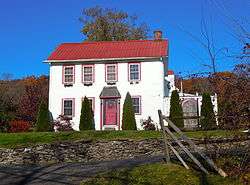 Landis Homestead on Morwood Road | |
| Country | United States |
|---|---|
| State | Pennsylvania |
| County | Montgomery |
| Elevation | 338 ft (103.0 m) |
| Coordinates | 40°20′03″N 75°22′58″W / 40.33417°N 75.38278°WCoordinates: 40°20′03″N 75°22′58″W / 40.33417°N 75.38278°W |
| Area | 9.6 sq mi (24.9 km2) |
| - land | 9.5 sq mi (25 km2) |
| - water | 0.04 sq mi (0 km2), 0.42% |
| Population | 2,504 (2010) |
| Density | 247.8/sq mi (95.7/km2) |
| Timezone | EST (UTC-5) |
| - summer (DST) | EDT (UTC-4) |
| Area code | 215 |
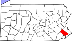
 Location of Salford Township in Montgomery County | |
 Location of Salford Township in Pennsylvania | |
 Location of Pennsylvania in the United States | |
| Website: http://www.salfordtownship.com | |
Salford Township is a township in Montgomery County, Pennsylvania, United States. The population was 2,504 at the 2010 census.
History
The Landis Homestead was listed on the National Register of Historic Places in 1986.[1]
Geography
According to the United States Census Bureau, the township has a total area of 9.6 square miles (24.7 km2), of which, 9.5 square miles (24.7 km2) of it is land and 0.04 square miles (0.1 km2) of it (0.21%) is water. It is drained by the Perkiomen Creek into the Schuylkill River. Its villages include Earlington, Naceville (also in Bucks County,) and Tylersport.
Neighboring municipalities
- Franconia Township (southeast)
- Upper Salford Township (southwest)
- Marlborough Township (northwest)
- West Rockhill Township, Bucks County (northeast)
Demographics
| Historical population | |||
|---|---|---|---|
| Census | Pop. | %± | |
| 1930 | 650 | — | |
| 1940 | 781 | 20.2% | |
| 1950 | 794 | 1.7% | |
| 1960 | 1,068 | 34.5% | |
| 1970 | 1,560 | 46.1% | |
| 1980 | 1,995 | 27.9% | |
| 1990 | 2,216 | 11.1% | |
| 2000 | 2,363 | 6.6% | |
| 2010 | 2,504 | 6.0% | |
| http://www.dvrpc.org/data/databull/rdb/db82/appedixa.xls. | |||
As of the 2010 census, the township was 96.8% White, 0.8% Black or African American, 0.2% Native American, 1.0% Asian, and 0.7% were two or more races. 1.3% of the population were of Hispanic or Latino ancestry .
As of the census[2] of 2000, there were 2,363 people, 807 households, and 677 families residing in the township. The population density was 247.8 people per square mile (95.6/km2). There were 821 housing units at an average density of 86.1/sq mi (33.2/km2). The racial makeup of the township was 97.33% White, 0.68% African American, 0.08% Native American, 0.76% Asian, 0.17% from other races, and 0.97% from two or more races. Hispanic or Latino of any race were 1.10% of the population.
There were 807 households, out of which 36.4% had children under the age of 18 living with them, 74.6% were married couples living together, 5.5% had a female householder with no husband present, and 16.1% were non-families. 12.5% of all households were made up of individuals, and 4.2% had someone living alone who was 65 years of age or older. The average household size was 2.92 and the average family size was 3.19.
In the township the population was spread out, with 25.8% under the age of 18, 7.2% from 18 to 24, 27.1% from 25 to 44, 29.4% from 45 to 64, and 10.5% who were 65 years of age or older. The median age was 40 years. For every 100 females there were 101.3 males. For every 100 females age 18 and over, there were 103.1 males.
The median income for a household in the township was $66,775, and the median income for a family was $73,750. Males had a median income of $46,731 versus $28,250 for females. The per capita income for the township was $29,740. About 0.9% of families and 2.6% of the population were below the poverty line, including 1.2% of those under age 18 and 4.1% of those age 65 or over.
Government and politics
| Year | Republican | Democratic |
|---|---|---|
| 2012 | 63.2% 881 | 34.8% 486 |
| 2008 | 57.2% 791 | 42.2% 584 |
| 2004 | 61.8% 841 | 37.9% 516 |
| 2000 | 62.0% 646 | 34.2% 356 |
| 1996 | 52.5% 469 | 31.7% 283 |
| 1992 | 45.7% 431 | 26.8% 253 |
References
- ↑ National Park Service (2010-07-09). "National Register Information System". National Register of Historic Places. National Park Service.
- ↑ "American FactFinder". United States Census Bureau. Retrieved 2008-01-31.