Sainte-Foy, Quebec City
| Sainte-Foy | |
|---|---|
| Borough | |
|
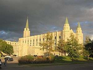
Boulevard Laurier in Sainte-Foy | |
|
Motto: "Fide Et Labore Valebo" (Latin) "My worthiness stems from my faith and labour" | |
| Province | Quebec |
| MRC | None |
| Established | January 1, 2002 |
| Area | |
| • Total | 83.87 km2 (32.38 sq mi) |
| Population (2006)[1] | |
| • Total | 104,890 |
| Time zone | EST (UTC-5) |
| • Summer (DST) | EDT (UTC-4) |

Sainte-Foy /seɪntˈfwɑː/ is a former city in central Quebec, Canada on the Saint Lawrence River. It was amalgamated into Quebec City on January 1, 2002. Most of Sainte-Foy is in the Borough of Sainte-Foy–Sillery–Cap-Rouge.
Sainte-Foy is a major suburban neighbourhood west of downtown Quebec City. It is a great part of Quebec City's economic life by the presence of the Jean Lesage International Airport, Université Laval, many shopping malls and both bridges to the south shore of the Saint Lawrence River.
Demographics
According to the Canada 2006 Census:
- Population: 76,262
- % Change (2001–2006): +5.1
- Dwellings: 40,487
- Number of families: 20,680
- Area (km²): 83.87 km²
- Density (persons per km²): 909.3

History
In 1669, Father Chaumonot erected a chapel for the Hurons which was dedicated to Notre-Dame de Foy. Sainte-Foy's beginnings started here.
The Battle of Sainte-Foy, sometimes called the Battle of Quebec, was fought on April 28, 1760 in this area during the Seven Years' War (called the French and Indian War in the United States). It was a victory for the French under the Chevalier de Lévis over the British army under General Murray. When compared to the Battle of the Plains of Abraham of the previous September, this battle proved to be a much bloodier affair in terms of the total number of casualties incurred by both sides – 833 French casualties to 1,124 British casualties. It was the last French victory of the Seven Years' War.
Sainte-Foy's long-time and flamboyant mayor, the late Andrée Boucher, was defeated when she tried to run for mayor of the amalgamated Quebec City. She then became a radio host. In 2005, she tried once again to run for mayor when Jean-Paul L'Allier retired. This time she succeeded, without an election team or advertisement, and with very few public appearances or debates.
Amalgamation with Quebec City
On January 1, 2002 the city was merged, along with many other suburbs, with Quebec City. However, this was done without any form of public referendum or widespread public approval. Consequently, a vote was finally held on June 20, 2004 offering cities to disband from the new setup. Only Saint-Augustin-de-Desmaures and L'Ancienne-Lorette disbanded from the newly formed city. Many believed that a "defusion" would only lead to an eventual and inevitable "refusion". The prospect of having to spend a lot of money undoing what had just been done discouraged most people to go vote, and in most of the old suburb cities not enough votes were cast for the vote to be valid.
Districts
Cité universitaire – Centered around Université Laval with a very large student population. The majority of Saint-Foy's commercial activity is found along Saint Laurence Boulevard, such as the Laurier Québec Place Sainte-Foy et Place de la Cité shopping malls. A number of large hotels and office buildings line the boulevard and has established itself as one of the city's major commercial centres.
Saint-Louis – Leafy residential area south of Saint Lawrence Boulevard towards the river. Contains the Aquarium du Québec.
Plateau – Sprawling suburban area north of Boulevard Laurier, featuring post-war single story houses and an abundance of 1960s apartment blocks.
Pointe-de-Ste-Foy – Recent large residential development, centered on the Campanile shopping street. The neighborhood mostly consists of large modern condo and apartment blocks.
L'Aéroport – Industrial area centered on the Jean Lesage International Airport with many big box stores.
Economy
Aeropro has its head office on the grounds of Jean Lesage Airport in Sainte-Foy.[1][2] It conducts business charters and recreational and sightseeing flights[3] Prior to its dissolution, regional airline Air Nova had its Quebec offices in Sainte-Foy.[4]
The VIA Rail station on the Quebec City–Windsor Corridor nearest Quebec City is located at Gare Sainte-Foy.[5] It is roughly 3 km distant from the Gare d'Autocar de Ste-Foy,[6] and 10 km distant from the Jean Lesage Airport.
The Gare d'Autocar is a regional hub for Orleans Express, Intercar, the Réseau de transport de la Capitale, the Société de transport de Lévis, and several regional government-funded navettes, for example Portneuf.[7]
Major companies operating in the district include PriceWaterhouseCoppers, Ernst & Young, Microsoft and the headquarters of SSQ Financial Group.
Sainte-Foy is at the northern end of the Quebec Bridge, which links to the south shore of the Saint Lawrence River at Lévis.
Education
Sainte-Foy is also the site of many educational institutions:
- Université Laval
- Cégep Sainte-Foy
- Cégep Garneau
- College de Champigny
- Champlain College St. Lawrence
- Rochebelle High School –
- College des Compagnons –
- Université du Québec École Nationale d'Administration Publique
Transport
Sainte-Foy railway station is in the borough.
Air France has a bus service from the station to Montreal Dorval Airport for its customers only.[8]
Recreation
Sainte-Foy possesses 3 Ice Hockey Rinks, 1 Sports Center, 33 Soccer Fields, 2 Interior Pools, 13 Exterior Pools, 3 Cinemas, 1 Theatre, Laurier Québec, Place de La Cite, la Pyramide. Sainte-Foy also has the pride of having excellent sports representations in all sports. It has the Governors at Hockey, the Caravelles and Arsenal at Soccer, and the Musketeers ESCC at Basketball.
Notable residents
- Sylvie Bernier – won the gold medal in diving at the 1984 Olympics[9]
- Patrick Roy – NHL Goaltender[10]
- Jean Leloup – Musician
- Simon Gagné – NHL Left Winger[11]
See also
References
- ↑ "Contact us." Aeropro. Retrieved on June 26, 2010.
- ↑ "Plan_QC.doc." Aéropro. Retrieved on June 26, 2010.
- ↑ "Aéropro." Aéropro. Retrieved on January 26, 2011.
- ↑ "Our Facilities." Air Nova. August 23, 2000. Retrieved on June 18, 2009.
- ↑ viarail.ca: "Sainte-Foy train station"
- ↑ bonjourquebec.com: "Gare d'autocar de Ste-Foy"
- ↑ transportportneuf.com: "Navettes journalières Portneuf-Québec"
- ↑ "A new bus service to Quebec City." Air France. August 16, 2016. Retrieved on October 29, 2016.
- ↑ "Bernier Picked for Beijing." The Globe and Mail. April 29, 2006. Retrieved on June 18, 2009.
- ↑ "Roy lacks class that Canadiens value so highly." ESPN. Tuesday March 25, 2008. Retrieved on June 18, 2009.
- ↑ Gelston, Par Dan. "Simon Gagné a repris la forme qu'il affichait avant la commotion cérébrale." Associated Press at Jminforme.ca. January 16, 2009. Retrieved on June 18, 2009.
- Modification aux arrondissements (archive Chartrand, Rene (2000). Canadian Military Heritage. Casemate Publishing. ISBN 2-920718-51-7).
| Boroughs |  | |
|---|---|---|
| Districts | ||
| Agglomeration | ||
| Enclaves | ||
| ||
Coordinates: 46°47′N 71°18′W / 46.783°N 71.300°W