Sainte-Croix-Vallée-Française
| Sainte-Croix-Vallée-Française | |
|---|---|
|
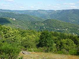
A view of the Vallée française between Saint-Jean-du-Gard and Florac | |
 Sainte-Croix-Vallée-Française | |
|
Location within Occitanie region  Sainte-Croix-Vallée-Française | |
| Coordinates: 44°10′51″N 3°44′35″E / 44.1808°N 3.7431°ECoordinates: 44°10′51″N 3°44′35″E / 44.1808°N 3.7431°E | |
| Country | France |
| Region | Occitanie |
| Department | Lozère |
| Arrondissement | Florac |
| Canton | Barre-des-Cévennes |
| Intercommunality | Cévenne des Hauts Gardons |
| Government | |
| • Mayor (2008–2014) | Michèle Manoa |
| Area1 | 18.57 km2 (7.17 sq mi) |
| Population (1999)2 | 279 |
| • Density | 15/km2 (39/sq mi) |
| Time zone | CET (UTC+1) |
| • Summer (DST) | CEST (UTC+2) |
| INSEE/Postal code | 48144 / 48110 |
| Elevation |
320–924 m (1,050–3,031 ft) (avg. 350 m or 1,150 ft) |
|
1 French Land Register data, which excludes lakes, ponds, glaciers > 1 km² (0.386 sq mi or 247 acres) and river estuaries. 2 Population without double counting: residents of multiple communes (e.g., students and military personnel) only counted once. | |
Sainte-Croix-Vallée-Française is a commune in the Lozère department in southern France.
See also
References
| Wikimedia Commons has media related to Sainte-Croix-Vallée-Française. |
This article is issued from Wikipedia - version of the 2/1/2015. The text is available under the Creative Commons Attribution/Share Alike but additional terms may apply for the media files.