Saint Thomas, U.S. Virgin Islands
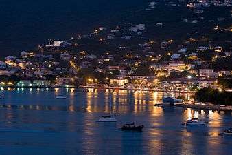
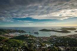 View of St. Thomas | |
 St. Thomas | |
| Geography | |
|---|---|
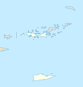
| Location | Caribbean Sea |
| Coordinates | 18°20′N 64°55′W / 18.333°N 64.917°WCoordinates: 18°20′N 64°55′W / 18.333°N 64.917°W |
| Archipelago | Virgin Islands, Leeward Islands |
| Area | 31.14 sq mi (80.7 km2) |
| Highest point | 1,550 or 474 meters |
| Administration | |
| Insular area | Virgin Islands |
| Largest settlement | Charlotte Amalie (pop. 18,481) |
| Demographics | |
| Population | 51,634 (2010) |
| Pop. density | 638.17 /km2 (1,652.85 /sq mi) |
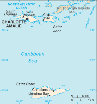
Saint Thomas (Spanish: Santo Tomás; Dutch: Sint-Thomas; Danish: Sankt Thomas) is one of the Virgin Islands in the Caribbean Sea and, together with St. John, Water Island and St. Croix, form a county and constituent district of the United States Virgin Islands (USVI), an unincorporated territory of the United States. Located on the island is the territorial capital and port of Charlotte Amalie. As of the 2010 census, the population of Saint Thomas was 51,634[1] about 48.5% of the US Virgin Islands total. The district has a land area of 31.24 square miles (80.9 km2).
History
Pre-colonial history
The island was originally settled around 1500 BC by the Ciboney people. They were later replaced by the Arawaks and then the Caribs. Christopher Columbus sighted the island in 1493 on his second voyage to the "New World".
Danish colonial period
The Dutch West India Company established a post on Saint Thomas in 1657. The first congregation was the St. Thomas Reformed Church, which was established in 1660 and was associated with the Dutch Reformed Church.
The Danish conquered the island in 1666, and by 1672 had established control over the entire island through the Danish West India and Guinea Company. The land was divided into plantations and sugarcane production became the primary economic activity. As a result, the economies of Saint Thomas and the neighboring islands of Saint John and Saint Croix became highly dependent on slave labor and the slave trade. In 1685, the Brandenburgisch-Africanische Compagnie took control of the slave trade on Saint Thomas, and for some time the largest slave auctions in the world were held there.
-1_Dollar_(1889).jpg)
Danish West Indies, Saint Thomas, 1 dollar (1889)
Saint Thomas's fine natural harbor became known as "Taphus" for the drinking establishments located nearby. ("Tap Hus" translates as "rum shop" or "tap house" referring to the drinking establishments.[2]) In 1691, the primary settlement there was renamed Charlotte Amalie in honor of the wife of Denmark's King Christian V. It was later declared a free port by Frederick V. In December 1732, the first two of many Moravian Brethren missionaries came from Herrnhut Saxony in present-day Germany to minister to them. Distrusted at first by the white masters, they lived among the slaves and soon won their confidence.[3]
From 1796 a small Jewish community developed in Charlotte Amalie. It established a historic synagogue, Beracha Veshalom Vegmiluth Hasidim, the oldest synagogue in continuous use in the United States.[4]
The first British invasion and occupation of the Danish West Indies occurred at the end of March 1801 when a British fleet arrived at St Thomas. The Danes accepted the Articles of Capitulation the British proposed and the British occupied the islands without a shot being fired. The British occupation lasted until April 1802, when the British returned the islands to Denmark.
The second British invasion of the Danish West Indies took place in December 1807 when a British fleet captured St Thomas on 22 December and Santa Cruz on 25 December. The Danes did not resist and the invasion was bloodless. This British occupation of the Danish West Indies lasted until 20 November 1815, when Britain returned the islands to Denmark.
While the sugar trade had brought prosperity to the island's free citizens, by the early 19th century Saint Thomas was in decline. The continued export of sugar was threatened by hurricanes, drought, and American competition. Following the Danish Revolution of 1848, slavery was abolished and the resulting rise in labor costs further weakened the position of Saint Thomas's sugar producers.
Given its harbors and fortifications, Saint Thomas still retained a strategic importance, and thus, in the 1860s, during the American Civil War and its aftermath, the United States government considered buying the island and its neighbors from Denmark for $7.5 million. However, the proponents of the purchase failed to gain legislative support for the bid.
David Hamilton Jackson
As the islands were poorly managed by the Danes, a local islander, David Hamilton Jackson, was instrumental in persuading the Danish to allow the US to purchase the islands of St. Thomas, St. John, and St. Croix. In 1915, he traveled to Denmark and convinced the King of Denmark to allow freedom of the press in the islands.[5] He began the first newspaper in the islands, known as The Herald. After this, he organized labor unions among the islanders for better working conditions. The islands now have an annual celebration to honor the legacy of David Hamilton Jackson.[6]
American acquisition
In 1917, St. Thomas was purchased (along with Saint John and Saint Croix) by the United States for $25 million in gold,[7] as part of a defensive strategy to maintain control over the Caribbean and the Panama Canal during the First World War. The transfer occurred on March 31, 1917, behind Fort Christian before the barracks that now house the Legislature of the U.S Virgin Islands. The baccalaureate service for the transfer was held at the St. Thomas Reformed Church as it was identified as the American church in the Danish West Indies.
Percival Wilson Sparks, a U.S. Naval officer, designed the flag that now represents the United States Virgin Islands. Sparks married a local U.S Virgin Island woman, Grace Joseph Sparks; when Sparks' superior, Rear Adm. Summer Ely Wetmore Kitelle, commissioned the design for the flag, P. W. Sparks asked his wife and her sister, Blanche Joseph (later Sasso), to sew the first flag. That flag was used until such time as a factory-produced flag could be acquired.
The flag's inspiration came from the U.S. Presidential seal. Sparks decided to have the eagle facing the olive branches (which represented peace) rather than the arrows (which represented the three islands: St. Croix, St. Thomas, and St. John). (At the request of Emilie Rose Sparks Gray, a daughter of P.W. Sparks and Grace Sparks, so that the family would have clear and undeniable proof, this piece of history was entered into the Congressional Record in Washington, D.C., on April 30, 1986,[8] by the congressional delegate, Ron de Lugo.) Every year Transfer Day is recognized as a holiday, to celebrate the acquisition of the islands by the United States in 1917.
U.S. citizenship was granted to the residents in 1927. The U.S. Department of the Interior took over administrative duties in 1931. American forces were based on the island during the Second World War. In 1954, passage of the U.S. Virgin Islands Organic Act officially granted territorial status to the three islands, and allowed for the formation of a local senate with politics dominated by the American Republican and Democratic parties. Full home rule was achieved in 1970.
The post-war era also saw the rise of tourism on the island. With relatively cheap air travel and the American embargo on Cuba, the numbers of visitors greatly increased. Despite natural disasters such as Hurricane Hugo (1989) and Hurricanes Luis and Marilyn (1995), the island's infrastructure continues to improve as the flow of visitors continues. Hotels have been built from the West End to the East End.
Climate
| Climate data for Saint Thomas, United States Virgin Islands | |||||||||||||
|---|---|---|---|---|---|---|---|---|---|---|---|---|---|
| Month | Jan | Feb | Mar | Apr | May | Jun | Jul | Aug | Sep | Oct | Nov | Dec | Year |
| Record high °F (°C) | 93 (34) |
93 (34) |
94 (34) |
96 (36) |
97 (36) |
99 (37) |
98 (37) |
99 (37) |
98 (37) |
97 (36) |
95 (35) |
92 (33) |
99 (37) |
| Average high °F (°C) | 85.1 (29.5) |
85.1 (29.5) |
85.7 (29.8) |
86.7 (30.4) |
87.6 (30.9) |
89.1 (31.7) |
89.9 (32.2) |
90.2 (32.3) |
90.0 (32.2) |
88.7 (31.5) |
87.1 (30.6) |
85.6 (29.8) |
87.6 (30.9) |
| Average low °F (°C) | 72.4 (22.4) |
72.3 (22.4) |
72.9 (22.7) |
74.1 (23.4) |
76.2 (24.6) |
77.7 (25.4) |
78.0 (25.6) |
78.1 (25.6) |
78.0 (25.6) |
76.9 (24.9) |
75.2 (24) |
73.7 (23.2) |
75.5 (24.2) |
| Record low °F (°C) | 63 (17) |
62 (17) |
56 (13) |
58 (14) |
66 (19) |
67 (19) |
57 (14) |
59 (15) |
64 (18) |
66 (19) |
52 (11) |
62 (17) |
52 (11) |
| Average precipitation inches (mm) | 2.16 (54.9) |
1.47 (37.3) |
1.05 (26.7) |
2.62 (66.5) |
3.05 (77.5) |
2.62 (66.5) |
2.82 (71.6) |
3.51 (89.2) |
4.82 (122.4) |
5.94 (150.9) |
6.00 (152.4) |
2.88 (73.2) |
38.95 (989.3) |
| Average precipitation days (≥ 0.01 in) | 14.3 | 11.8 | 8.1 | 10.7 | 11.9 | 11.1 | 14.8 | 14.2 | 14.6 | 17.7 | 17.8 | 16.7 | 163.6 |
| Source #1: NOAA (normals 1981−2010)[9] | |||||||||||||
| Source #2: Weather Channel [10] | |||||||||||||
Demographics
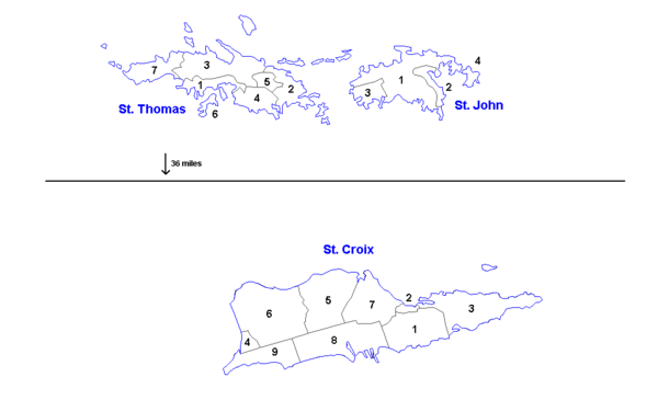
Saint Thomas is divided into the following subdistricts (with population as per the 2010 U.S. Census):
- Charlotte Amalie (pop. 18,481) Charlotte Amalie town (pop. 10,354)
- East End (pop. 8,403)
- Northside (pop. 10,049)
- Southside (pop. 5,411)
- Tutu (pop. 6,867)
- Water Island (pop. 182)
- West End (pop. 2,241)
Transportation

The island is serviced by the Cyril E. King Airport.
Passenger and limited car-ferry services to neighboring islands such as Water Island, St. John, St. Croix, and the British Virgin Islands run regularly out of the Red Hook Terminal, Charlotte Amalie, and Crown Bay Marina.
The United States Virgin Islands is the only place under United States jurisdiction where the rule of the road is to drive on the left. This was inherited from what was the then-current Danish practice at the time of the American acquisition in 1917. However, because St. Thomas is a U.S. territory, most cars are imported from the mainland United States and therefore the steering column is located on the left side of the vehicle.
The island has many regular taxis from compact size to large vans, as well as open-air, covered trucks called "safaris" with bench seats. The latter usually operate only between high-traffic points, e.g., cruise-ship terminals at Havensight and Crown Bay and downtown Charlotte Amalie.
Education
St. Thomas-St. John School District operates public schools on Saint Thomas.
Private schools on St. Thomas:
- Antilles School (www.antilles.vi)
- Virgin Islands Montessori School & International Academy
- Cavalry Christian Academy
Parochial schools on St. Thomas:
- All Saints Cathedral School
- Saints Peter & Paul Catholic School
- Weslyan Academy Bible School
Colleges and universities on St. Thomas:
Notable people
- Alton Augustus Adams − first African-American band master for the United States Navy
- Jabari Blash - Major League Baseball player, Outfielder for the San Diego Padres
- Edward Wilmot Blyden − ambassador, an Igbo in Diaspora, is credited in some history books as having laid the foundation of West African nationalism and Pan-Africanism
- Callix Crabbe − Major League Baseball player
- Midre Cummings − Major League Baseball player
- Vanessa Daou International Singer-Songwriter, Dancer, Writer, Poet
- Hannah Davis − fashion model
- Charles Sainte-Claire Deville − a French geologist
- Henri Sainte-Claire Deville − a French chemist
- Jeffrey Epstein - American financier
- Jeff Faulkner − National Football League player
- Kelsey Grammer − actor, director, and producer born in St. Thomas
- Emile Griffith − former boxer who won world championships in both the Welterweight and Middleweight divisions.
- Elrod Hendricks − Major League Baseball player
- Abdul Hodge − National Football League player
- Daryl Homer, Olympic fencer
- Roy Innis − civil rights leader
- Julian Jackson − boxer born in St. Thomas
- J. Raymond Jones − political activist
- Al McBean − Major League Baseball player
- Ralph Moses Paiewonsky − governor
- Calvin Pickering − Major League Baseball player.
- Camille Pissarro − a key member of the French Impressionist group of painters
- Rashawn Ross − Trumpeter who tours with Dave Matthews Band
- Roy Lester Schneider − governor and physician
- Karrine Steffans − former hip hop music video performer and actress and the author of Confessions of A Video Vixen.
- Morris Simmonds − German physician, pathologist, described a syndrome of pituitary failure with emaciation (Simmonds syndrome)
- Terence Todman − ambassador
- Jean Toussaint - jazz tenor and soprano saxophonist
- Peter von Scholten − governor general
- Denmark Vesey − leader of planned slave uprising in Charleston, South Carolina
- David Levy Yulee − an American politician and the first member of the United States Senate to have been, at one time, a practicing Jew.
Points of interest
- Blackbeard's Castle
- Buck Island National Wildlife Refuge
- Cathedral Church of All Saints
- Fort Christian
- Magens Bay Arboretum
- Magens Bay
- Saints Peter and Paul Cathedral
- St. Thomas Reformed Church
- St. Thomas Synagogue
- Coral World Ocean Park
- St Johns Fragrance Company[11]
Movies made on St. Thomas.
The only movie created on St. Thomas was Weekend at Bernie's II in 1993.
Gallery
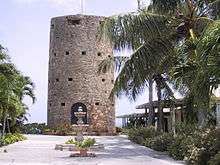 Blackbeard's Castle in Charlotte Amalie.
 The port at Charlotte Amalie March 2008.
 "Beautiful Harbor of St. Thomas, West Indies", stereoptical view, c. 1900.
 Magen's Beach as seen from Drake's Seat, St. Thomas, USVI.
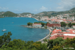 View From Blackbeard's Castle, St Thomas US Virgin Islands
 View of Blackbeard's Castle, from In Town
 Saint Thomas Shopping Square
 Beautiful Scenery
References
- ↑ "2010 Census U.S. Virgin Islands, United States Census Bureau". Retrieved December 17, 2011.
- ↑ "Charlotte Amalie St. Thomas U.S. Virgin Islands". guidetocaribbeanvacations.com.
- ↑ Hamilton, J. Taylor and Hamilton, Kenneth G., History of the Moravian Church, Bethlehem, PA, 1969.
- ↑ Arts & Culture US Virgin Island Tourism
- ↑ "David Hamilton Jackson - Famous Virgin Islander". here.vi.
- ↑ Liberty Day festivities to include parade, re-enactment about D. Hamilton Jackson, The Virgin Islands Daily News.
- ↑ "United States Virgin Islands Department of Tourism site". Visitusvi.com. Retrieved December 17, 2011.
- ↑ Congressional Record, vol. 132, No. 56.
- ↑ "NOWData - NOAA Online Weather Data". National Oceanic and Atmospheric Administration. Retrieved January 19, 2013.
- ↑ "Average Conditions Saint Thomas, VI". weather.com. Retrieved May 16, 2010.
- ↑ St Johns Fragrance Company™. "St Johns Bay Rum Aftershave and Cologne - Best Bay Rum for 70 Years". St Johns Fragrance Company™.
External links
| Wikimedia Commons has media related to Saint Thomas, United States Virgin Islands. |
| Wikivoyage has a travel guide for Saint Thomas. |
- Official sites
- United States Virgin Islands – Official Website for the United States Virgin Islands Department of Tourism
- Districts of the United States Virgin Islands, United States Census Bureau
- Map
- St. Thomas USVI Google Map – Satellite Map of St. Thomas, USVI
Charlotte Amalie (capital) | |
| Topics |
|
| Government | |
| Cities | |
| Islands | |
| Parks | |