Saint-Pierre-des-Nids
| Saint-Pierre-des-Nids | ||
|---|---|---|
|
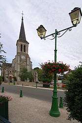
The church in Saint-Pierre-des-Nids | ||
| ||
 Saint-Pierre-des-Nids | ||
|
Location within Pays de la Loire region  Saint-Pierre-des-Nids | ||
| Coordinates: 48°23′59″N 0°05′54″W / 48.3997°N 0.0983°WCoordinates: 48°23′59″N 0°05′54″W / 48.3997°N 0.0983°W | ||
| Country | France | |
| Region | Pays de la Loire | |
| Department | Mayenne | |
| Arrondissement | Mayenne | |
| Canton | Pré-en-Pail | |
| Intercommunality | Avaloirs | |
| Government | ||
| • Mayor (2008–2014) | Henri Leblond | |
| Area1 | 37.34 km2 (14.42 sq mi) | |
| Population (1999)2 | 1,712 | |
| • Density | 46/km2 (120/sq mi) | |
| Time zone | CET (UTC+1) | |
| • Summer (DST) | CEST (UTC+2) | |
| INSEE/Postal code | 53246 / 53370 | |
| Elevation |
106–272 m (348–892 ft) (avg. 182 m or 597 ft) | |
|
1 French Land Register data, which excludes lakes, ponds, glaciers > 1 km² (0.386 sq mi or 247 acres) and river estuaries. 2 Population without double counting: residents of multiple communes (e.g., students and military personnel) only counted once. | ||

Saint-Pierre-des-Nids is a commune in the Mayenne department in north-western France.
See also
References
External links
| Wikimedia Commons has media related to Saint-Pierre-des-Nids. |
This article is issued from Wikipedia - version of the 10/2/2015. The text is available under the Creative Commons Attribution/Share Alike but additional terms may apply for the media files.