Saint-Nabord
| Saint-Nabord | ||
|---|---|---|
|
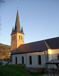
Saints Nabord and Gorgonius Church | ||
| ||
 Saint-Nabord | ||
|
Location within Grand Est region  Saint-Nabord | ||
| Coordinates: 48°03′01″N 6°34′50″E / 48.0503°N 6.5806°ECoordinates: 48°03′01″N 6°34′50″E / 48.0503°N 6.5806°E | ||
| Country | France | |
| Region | Grand Est | |
| Department | Vosges | |
| Arrondissement | Épinal | |
| Canton | Remiremont | |
| Intercommunality | Porte des Hautes-Vosges | |
| Government | ||
| • Mayor (2008–2014) | Michèle Asnard | |
| Area1 | 38.5 km2 (14.9 sq mi) | |
| Population (2006)2 | 4,182 | |
| • Density | 110/km2 (280/sq mi) | |
| Time zone | CET (UTC+1) | |
| • Summer (DST) | CEST (UTC+2) | |
| INSEE/Postal code | 88429 / 88200 | |
| Elevation |
367–632 m (1,204–2,073 ft) (avg. 411 m or 1,348 ft) | |
| Website | www.ville-saint-nabord.fr | |
|
1 French Land Register data, which excludes lakes, ponds, glaciers > 1 km² (0.386 sq mi or 247 acres) and river estuaries. 2 Population without double counting: residents of multiple communes (e.g., students and military personnel) only counted once. | ||

Saint-Nabord is a commune in the Vosges department in Grand Est in northeastern France.
See also
References
External links
| Wikimedia Commons has media related to Saint-Nabord. |
This article is issued from Wikipedia - version of the 11/6/2016. The text is available under the Creative Commons Attribution/Share Alike but additional terms may apply for the media files.