Saint-Jean-de-Côle
| Saint-Jean-de-Côle | |
|---|---|
.JPG) | |
 Saint-Jean-de-Côle | |
|
Location within Nouvelle-Aquitaine region  Saint-Jean-de-Côle | |
| Coordinates: 45°25′19″N 0°50′21″E / 45.4219°N 0.8392°ECoordinates: 45°25′19″N 0°50′21″E / 45.4219°N 0.8392°E | |
| Country | France |
| Region | Nouvelle-Aquitaine |
| Department | Dordogne |
| Arrondissement | Nontron |
| Canton | Thiviers |
| Intercommunality | Pays Thibérien |
| Government | |
| • Mayor (2008–2014) | Francis Sedan |
| Area1 | 12.70 km2 (4.90 sq mi) |
| Population (2008)2 | 349 |
| • Density | 27/km2 (71/sq mi) |
| Time zone | CET (UTC+1) |
| • Summer (DST) | CEST (UTC+2) |
| INSEE/Postal code | 24425 / 24800 |
| Elevation |
135–252 m (443–827 ft) (avg. 149 m or 489 ft) |
|
1 French Land Register data, which excludes lakes, ponds, glaciers > 1 km² (0.386 sq mi or 247 acres) and river estuaries. 2 Population without double counting: residents of multiple communes (e.g., students and military personnel) only counted once. | |
Saint-Jean-de-Côle is a commune in the Dordogne department in Nouvelle-Aquitaine in southwestern France.
Geography
The Côle flows south-southwest through the middle of the commune and crosses the village.
Population
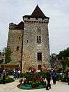
- Views of Saint-Jean-de-Côle

.JPG)
| Historical population | ||
|---|---|---|
| Year | Pop. | ±% |
| 1793 | 825 | — |
| 1800 | 887 | +7.5% |
| 1806 | 738 | −16.8% |
| 1821 | 810 | +9.8% |
| 1831 | 894 | +10.4% |
| 1836 | 922 | +3.1% |
| 1841 | 902 | −2.2% |
| 1846 | 885 | −1.9% |
| 1851 | 970 | +9.6% |
| 1856 | 932 | −3.9% |
| 1861 | 939 | +0.8% |
| 1866 | 959 | +2.1% |
| 1872 | 879 | −8.3% |
| 1876 | 894 | +1.7% |
| 1881 | 864 | −3.4% |
| 1886 | 1,107 | +28.1% |
| 1891 | 824 | −25.6% |
| 1896 | 751 | −8.9% |
| 1901 | 794 | +5.7% |
| 1906 | 815 | +2.6% |
| 1911 | 722 | −11.4% |
| 1921 | 613 | −15.1% |
| 1926 | 603 | −1.6% |
| 1931 | 518 | −14.1% |
| 1936 | 505 | −2.5% |
| 1946 | 479 | −5.1% |
| 1954 | 419 | −12.5% |
| 1962 | 381 | −9.1% |
| 1968 | 318 | −16.5% |
| 1975 | 318 | +0.0% |
| 1982 | 343 | +7.9% |
| 1990 | 339 | −1.2% |
| 1999 | 326 | −3.8% |
| 2008 | 349 | +7.1% |
See also
References
| Wikimedia Commons has media related to Saint-Jean-de-Côle. |
This article is issued from Wikipedia - version of the 11/9/2016. The text is available under the Creative Commons Attribution/Share Alike but additional terms may apply for the media files.