Saint-Ghislain
For the 7th-century Belgian saint, see Saint Ghislain.
| Saint-Ghislain | |||
|---|---|---|---|
| Municipality | |||
|
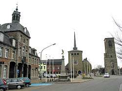
Saint-Ghislain: the former town hall (1752), the new church, and the tower of the old church (16th century) | |||
| |||
 Saint-Ghislain Location in Belgium | |||
|
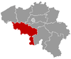
Location of Saint-Ghislain in Hainaut  | |||
| Coordinates: 50°27′N 03°49′E / 50.450°N 3.817°ECoordinates: 50°27′N 03°49′E / 50.450°N 3.817°E | |||
| Country | Belgium | ||
| Community | French Community | ||
| Region | Wallonia | ||
| Province | Hainaut | ||
| Arrondissement | Mons | ||
| Government | |||
| • Mayor | Daniel Olivier | ||
| • Governing party/ies | PS | ||
| Area | |||
| • Total | 70.18 km2 (27.10 sq mi) | ||
| Population (1 January 2016)[1] | |||
| • Total | 23,085 | ||
| • Density | 330/km2 (850/sq mi) | ||
| Postal codes | 7330-7334 | ||
| Area codes | 065 | ||
| Website | www.saint-ghislain.be | ||


Saint-Ghislain (Picard: Sint-Guilin) is a Walloon municipality located in the Belgian province of Hainaut. On 1 January 2006 the municipality had 22,466 inhabitants. The total area is 70.18 km², giving a population density of 320 inhabitants per km².
History
The town is named after Saint Ghislain. In the 7th century, with two unknown disciples Ghislain made a clearing in the vicinity of Castrilocus (now Mons), later taking up his abode at a place called Ursidongus, where he built an oratory or chapel dedicated to Saints Peter and Paul. Ursidongus was later named after him.
Economy
Google chose Saint-Ghislain in 2007 to host its new major European datacenter. Google currently has 12 people employed full-time as of 13 October 2011.
People born in Saint-Ghislain
- Johannes Ockeghem, composer (between 1410 and 1425)
References
- ↑ Population per municipality as of 1 January 2016 (XLS; 397 KB)
External links
-
 Media related to Saint-Ghislain at Wikimedia Commons
 |
Chièvres | Jurbise | | |
| Belœil Bernissart |
|
Mons | ||
| ||||
| | ||||
| Hensies | Boussu, Quaregnon |
This article is issued from Wikipedia - version of the 12/1/2016. The text is available under the Creative Commons Attribution/Share Alike but additional terms may apply for the media files.