Saint-André-de-Majencoules
| Saint-André-de-Majencoules | ||
|---|---|---|
|
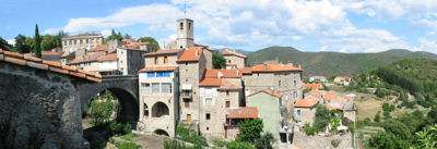
Château du Rey | ||
| ||
 Saint-André-de-Majencoules | ||
|
Location within Occitanie region  Saint-André-de-Majencoules | ||
| Coordinates: 44°01′46″N 3°40′28″E / 44.0294°N 3.6744°ECoordinates: 44°01′46″N 3°40′28″E / 44.0294°N 3.6744°E | ||
| Country | France | |
| Region | Occitanie | |
| Department | Gard | |
| Arrondissement | Le Vigan | |
| Canton | Valleraugue | |
| Intercommunality | Aigoual | |
| Government | ||
| • Mayor (2001–2008) | Christiane d'Arnal | |
| Area1 | 21.79 km2 (8.41 sq mi) | |
| Population (2008)2 | 581 | |
| • Density | 27/km2 (69/sq mi) | |
| Time zone | CET (UTC+1) | |
| • Summer (DST) | CEST (UTC+2) | |
| INSEE/Postal code | 30229 / 30570 | |
| Elevation |
180–900 m (590–2,950 ft) (avg. 352 m or 1,155 ft) | |
|
1 French Land Register data, which excludes lakes, ponds, glaciers > 1 km² (0.386 sq mi or 247 acres) and river estuaries. 2 Population without double counting: residents of multiple communes (e.g., students and military personnel) only counted once. | ||
.JPG)
.svg.png)
Saint-André-de-Majencoules is a commune in the Gard department in southern France.
Population
| Historical population | ||
|---|---|---|
| Year | Pop. | ±% |
| 1962 | 586 | — |
| 1968 | 661 | +12.8% |
| 1975 | 588 | −11.0% |
| 1982 | 547 | −7.0% |
| 1990 | 564 | +3.1% |
| 1999 | 556 | −1.4% |
| 2008 | 581 | +4.5% |
See also
References
| Wikimedia Commons has media related to Saint-André-de-Majencoules. |
This article is issued from Wikipedia - version of the 3/13/2014. The text is available under the Creative Commons Attribution/Share Alike but additional terms may apply for the media files.