Saint-Étienne-en-Dévoluy
| Saint-Étienne-en-Dévoluy | ||
|---|---|---|
|
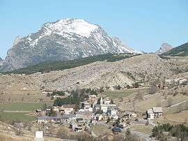
The village of Saint-Étienne-en-Dévoluy, with the south face of Le Gicon in the background | ||
| ||
 Saint-Étienne-en-Dévoluy | ||
|
Location within Provence-A.-C.d'A. region  Saint-Étienne-en-Dévoluy | ||
| Coordinates: 44°41′36″N 5°56′31″E / 44.6933°N 5.9419°ECoordinates: 44°41′36″N 5°56′31″E / 44.6933°N 5.9419°E | ||
| Country | France | |
| Region | Provence-Alpes-Côte d'Azur | |
| Department | Hautes-Alpes | |
| Arrondissement | Gap | |
| Canton | Saint-Étienne-en-Dévoluy | |
| Intercommunality | Dévoluy | |
| Government | ||
| • Mayor (2008–2014) | Jean-Marie Bernard | |
| Area1 | 67.87 km2 (26.20 sq mi) | |
| Population (2008)2 | 573 | |
| • Density | 8.4/km2 (22/sq mi) | |
| Time zone | CET (UTC+1) | |
| • Summer (DST) | CEST (UTC+2) | |
| INSEE/Postal code | 05139 / 05250 | |
| Elevation |
1,134–2,652 m (3,720–8,701 ft) (avg. 1,263 m or 4,144 ft) | |
|
1 French Land Register data, which excludes lakes, ponds, glaciers > 1 km² (0.386 sq mi or 247 acres) and river estuaries. 2 Population without double counting: residents of multiple communes (e.g., students and military personnel) only counted once. | ||

Saint-Étienne-en-Dévoluy is a former commune in the Hautes-Alpes department in southeastern France. On 1 January 2013, Agnières-en-Dévoluy, La Cluse, Saint-Disdier, and Saint-Étienne-en-Dévoluy amalgamated into the new commune of Le Dévoluy.
SuperDévoluy, a ski resort, was part of the commune.
Population
| Historical population | ||
|---|---|---|
| Year | Pop. | ±% |
| 1962 | 385 | — |
| 1968 | 417 | +8.3% |
| 1975 | 471 | +12.9% |
| 1982 | 527 | +11.9% |
| 1990 | 538 | +2.1% |
| 1999 | 538 | +0.0% |
| 2008 | 573 | +6.5% |
See also
References
| Wikimedia Commons has media related to Saint-Étienne-en-Dévoluy. |
This article is issued from Wikipedia - version of the 7/23/2015. The text is available under the Creative Commons Attribution/Share Alike but additional terms may apply for the media files.