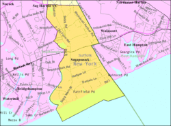
Sagaponack, New York
| Sagaponack, New York | |
|---|---|
| Village | |
| Village of Sagaponack | |
|
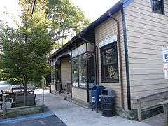
Sagaponack Village Hall, located at 3175 Montauk Highway in Sagaponack | |
| Nickname(s): Sagg | |
 | |
 Sagaponack | |
| Coordinates: 40°56′31″N 72°16′52″W / 40.94194°N 72.28111°WCoordinates: 40°56′31″N 72°16′52″W / 40.94194°N 72.28111°W | |
| Country | United States |
| State | New York |
| County | Suffolk |
| Town | Southampton |
| Incorporated | 2005 |
| Area | |
| • Total | 4.7 sq mi (12.1 km2) |
| • Land | 4.4 sq mi (11.4 km2) |
| • Water | 0.2 sq mi (0.6 km2) |
| Elevation | 23 ft (7 m) |
| Population (2010)[1] | |
| • Total | 313 |
| • Density | 67/sq mi (26/km2) |
| Time zone | Eastern (EST) (UTC-5) |
| • Summer (DST) | EDT (UTC-4) |
| ZIP code | 11962 |
| Area code(s) | 631 |
| FIPS code | 36-64452 |
| GNIS feature ID | 0963225 |
| Website |
www |


Sagaponack /sæɡəˈpɒnək/ is a village in the Town of Southampton in Suffolk County, New York, United States, on the East End of Long Island. The village was incorporated on September 2, 2005.
The population of Sagaponack village at the 2010 census was 313.[2] Prior to its incorporation, Sagaponack was a census-designated place, with a population at the 2000 census of 582 for an area 70% greater than that of the current village.[1] In 2016, according to Business Insider, the 11962 zip code encompassing Sagaponack was listed as the most expensive in the U.S., with a median home sale price of $8.5 million.[3]
The name Sagaponack comes from the Shinnecock Indian Nation word for "land of the big ground nuts", in reference to the Ground Nut (Apios americana). A common misconception is that the name referred to potatoes, the predominant crop grown by farmers who first settled the area. Many of the huge estates in the village were built on former potato fields. Its first settler was Josiah Stanborough[4] in 1656. The village was originally called Sagg.[5]
Sag Harbor, just north of Sagaponack, is believed to have derived its name from the village. West of Sagaponack is a place that the Indians called Mecox, now a hamlet on the west side of Sagaponack Lake in the town of Bridgehampton.[5]
The village was incorporated in the wake of the failed attempt by Dunehampton, New York to incorporate. Dunehampton's incorporation would have blocked Sagaponack from beaches on the Atlantic Ocean. The villages are seeking to address various beach issues including erosion arising from groynes at Georgica Pond in East Hampton village.
Geography
According to the United States Census Bureau, Sagaponack village has a total area of 4.7 square miles (12.1 km2), of which 4.4 square miles (11.4 km2) is land and 0.23 square miles (0.6 km2), or 5.15%, is water. At the 2000 census, the Sagaponack CDP had a total area of 8.0 square miles (21 km2), of which 6.2 square miles (16 km2) was land and 1.8 square miles (4.7 km2), or 22.35%, was water.
Demographics
| Historical population | |||
|---|---|---|---|
| Census | Pop. | %± | |
| 2010 | 313 | — | |
| Est. 2015 | 325 | [6] | 3.8% |
As of the census of 2000, there were 582 people, 249 households, and 162 families residing in the CDP. The population density was 93.6 people per square mile (36.1/km²). There were 734 housing units at an average density of 118.0 per square mile (45.6/km²). The racial makeup of the CDP was 92.78% White, 2.58% African American, 2.58% Asian, 1.55% from other races, and 0.52% from two or more races. Hispanic or Latino of any race were 3.44% of the population.[1]
There were 249 households out of which 24.9% had children under the age of 18 living with them, 55.0% were married couples living together, 6.8% had a female householder with no husband present, and 34.9% were non-families. 27.7% of all households were made up of individuals and 8.4% had someone living alone who was 65 years of age or older. The average household size was 2.34 and the average family size was 2.86.[1]
In the CDP the population was spread out with 19.4% under the age of 18, 4.0% from 18 to 24, 24.6% from 25 to 44, 33.8% from 45 to 64, and 18.2% who were 65 years of age or older. The median age was 46 years. For every 100 females there were 102.1 males. For every 100 females age 18 and over, there were 101.3 males.[1]
The median income for a household in the CDP was $54,048, and the median income for a family was $78,707. Males had a median income of $43,750 versus $27,321 for females. The per capita income for the CDP was $44,474. About 1.9% of families and 1.3% of the population were below the poverty line, including 2.5% of those under age 18 and 1.8% of those age 65 or over.[1]
Notable residents (and former residents)
- Charles Addams (1912-1988), cartoonist[8]
- Lloyd Blankfein, CEO, Goldman Sachs[9]
- Jimmy Fallon, television host[9]
- Lewis Frankfort, CEO, Coach[9]
- Peter Matthiessen, author, conservationist and naturalist
- Ira Rennert, investor and businessman[10]
- Truman Capote, Author
- George Plimpton, Author
- Kurt Vonnegut, Author
- E. L. Doctorow, Author
- David Salle, Artist
- Roy Scheider, Actor
- Billy Joel, Musician[11]
- Caroline Kennedy, former first daughter, lawyer, author and diplomat
- Susan Blond, publicist and Warhol movie star[12]
The village is also well known as the summer residence of several current and former Goldman Sachs bankers and private equity professionals.
Real Estate
Sagaponack is generally considered to be the most expensive neighborhood in the Hamptons,[13] as well as in the United States as a whole, generally ranking in the top spot on all major surveys. The Sagaponack ZIP Code (11962) was listed as the most expensive in the United States in 2009; the median home sale price was $4,421,458, according to Zillow.com. Nearby Watermill (11976) was listed sixth with $2,238,676, and Bridgehampton (11932) was listed eighth with $2,081,717.[14] In 2015, according to Business Insider, Sagaponack's 11962 zip code was listed as the most expensive in the U.S., this time by real estate-listings site Property Shark, with a median home sale price of $5,125,000.[15] Forbes ranked Sagaponack as the second most expensive zip code in the USA in 2014 and 2015.
Schools
- Sagaponack Common School
The village includes one of the last remaining active one-room school houses in New York State. The building, known locally as the "Little Red School House," educates children in grades Kindergarten through third grade.
See also
References
- 1 2 3 4 5 6 "American FactFinder". United States Census Bureau. Retrieved 2008-01-31.
- ↑ "Geographic Identifiers: 2010 Demographic Profile Data (G001): Sagaponack village, New York". U.S. Census Bureau, American Factfinder. Retrieved 2012-12-21.
- ↑ Raisa Bruner (March 7, 2016). "The 25 most expensive ZIP codes in America". Business Insider. Retrieved March 9, 2016.
- ↑ "Josiah Stanborough, Sr.". geni_family_tree. Retrieved 2016-02-19.
- 1 2 http://sagaponackview.net/sag.html
- ↑ "Annual Estimates of the Resident Population for Incorporated Places: April 1, 2010 to July 1, 2015". Retrieved July 2, 2016.
- ↑ "Census of Population and Housing". Census.gov. Retrieved June 4, 2015.
- ↑ Charles Addams
- 1 2 3 "They're rich & powerless". New York Post. September 2, 2011.
- ↑ "Rennert redux". New York Magazine.
- ↑ "Billy Joel relists home he's been trying to sell for the longest time".
- ↑ http://nypost.com/2015/05/19/p-r-maven-susan-blond-rents-out-her-sagaponack-beach-home/
- ↑ Insider, Business. "The 10 most expensive ZIP codes in America". The Real Deal New York. Retrieved 2016-02-11.
- ↑ http://www.businessweek.com/lifestyle/content/jan2010/bw20100119_111585.htm
- ↑ Accessed July 5, 2015.