Sagamihara
| Sagamihara 相模原市 | |||
|---|---|---|---|
| Designated city | |||
| Sagamihara City | |||
|
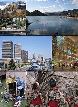
From top left: Tanzawa mountains, USARJ Sagami General Depot, Lake Sagami, Hashimoto District, Odakyu Sagami-Ōno Station, JAXA Sagamihara Campus, Sakura Festival | |||
| |||
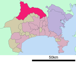 Location of Sagamihara in Kanagawa Prefecture | |||
 Sagamihara
| |||
| Coordinates: 35°34′N 139°22′E / 35.567°N 139.367°ECoordinates: 35°34′N 139°22′E / 35.567°N 139.367°E | |||
| Country | Japan | ||
| Region | Kantō | ||
| Prefecture | Kanagawa Prefecture | ||
| Government | |||
| • Mayor | Toshio Kayama | ||
| Area | |||
| • Total | 328.66 km2 (126.90 sq mi) | ||
| Population (October 1, 2016) | |||
| • Total | 721,686 | ||
| • Density | 2,194.84/km2 (5,684.6/sq mi) | ||
| Time zone | Japan Standard Time (UTC+9) | ||
| - Tree | Zelkova serrata | ||
| - Flower | Hydrangea | ||
| - Bird | Skylark | ||
| Phone number | 042-754-1111 | ||
| Address | 2-11-15 Chūō, Chūō-ku, Sagamihara-shi, Kanagawa-ken 252-5277 | ||
| Website |
www | ||


Sagamihara (相模原市 Sagamihara-shi) is a city in north-central Kanagawa Prefecture, bordering Tokyo, Japan. It is the third most populous city in the prefecture, after Yokohama and Kawasaki, and the fifth most populous suburb of Greater Tokyo. Its northern neighbor is Machida, with which a cross-prefectural merger has been proposed.[1]
As of October 2016, the city has an estimated population of 721,686 and a population density of 2,194.84 persons per km². The total area was 328.66 km².
On 1 April 2010, the city became the 19th city designated by government ordinance. As a result of this, three wards were established: Midori-ku, Chūō-ku and Minami-ku.
History
The area of modern Sagamihara has been settled since ancient times, and has a number of remains from the Japanese Paleolithic period and Kofun period have been found. It was home to the Yokoyama clan, one of the seven warrior clans of the Musashi region during the early Kamakura period. During the Edo period, the lands around Sagamihara were tenryō territory theoretically administered directly by the Tokugawa Shogunate in Edo; however, in reality, the area was a patchwork of small fiefs held by various hatamoto, as well as exclaves under the control of the Ogino-Yamanaka Domain and Karasuyama Domain.
After the Meiji Restoration, the eastern portion was part of Kōza District, and the western portion was part of Tsukui District. The Kōza District portion was administratively divided into six villages on 1 April 1889. The area was the location of extensive training facilities and arsenals of the Imperial Japanese Army during the 1930s. These villages were merged on 29 April 1941 together with neighboring Zama Town to create Sagamihara Town. At the time of its formation, it was the largest town in Japan in terms of area.
On 1 September 1948 Zama was administratively separated into Zama Town. The remaining portion became Sagamihara City on 20 November 1954. The city population had grown steadily, partly due to local industrial development, and partly due to the city's excellent transportation infrastructure connecting it to Yokohama, Tokyo and Hachiōji. It was designated a core city with increased autonomy in 2003.
On 20 March 2006, Sagamihara absorbed the towns of Tsukui and Sagamiko (both from Tsukui District). The merged city consisted of two geographically separate areas, as two other towns of Tsukui District (Fujino and Shiroyama) elected to remain separate. A further merger on 11 March 2007 joined Fujino and Shiroyama with Sagamihara, thus geographically unifying the city, and dissolving former Tsukui District. In 2007, the population of Sagamihara exceeded 700,000. In 2010, Sagamihara was redesignated as a government ordinance city and split into 3 wards Midori-ku, Chūō-ku, and Minami-ku.
On 25 July 2016, 19 people were killed and 26 injured in a mass stabbing incident at a disabled care home in the city.[2]
Geography
Sagamihara covers a large area of northwestern Kanagawa Prefecture. The main areas of commercial activity in Sagamihara are located near Hashimoto Station on the JR East Yokohama Line and Keio Sagamihara Line; Sagamihara Station on the Yokohama Line; and Sagami-Ōno Station on the Odakyu Odawara Line. Western Sagamihara is within the Tanzawa Mountains.
Wards
Surrounding municipalities
Transportation
Rail
- JR East - Yokohama Line
- Kobuchi - Fuchinobe - Yabe - Sagamihara - Hashimoto
- JR East - Sagami Line
- Sōbudai-shita - Shimomizo - Harataima - Banda - Kamimizo - Minami-Hashimoto - Hashimoto
- JR East - Chūō Main Line
- Odakyu Electric Railway - Odakyu Odawara Line
- Keio Corporation - Sagamihara Line
- Hashimoto
Highways
- Chūō Expressway
- Ken-Ō Expressway
- Japan National Route 16
- Japan National Route 20
- Japan National Route 129
- Japan National Route 412
- Japan National Route 413
Tourist attractions
- Sagami Lake
- Yōgen Temple (妙現寺), built in 1598
- Sagamihara Prefectural Park
Sports
Sister cities
 Toronto, Ontario, Canada since 1 January 1998
- Trail, British Columbia, Canada, since 15 April 1991
 Wuxi, China, since 6 October 1985
References
- ↑ Merger proposal (Japanese) (Translate to English: Google, Bing)
- ↑ McCurry, Justin (26 July 2016). "Japan Knife Attack: Stabbing at Care Centre Leaves 19 Dead and Dozens Wounded". The Guardian. Guardian News and Media. Retrieved 26 July 2016.
| Wikivoyage has a travel guide for Sagamihara#b. |
External links
| Wikimedia Commons has media related to Sagamihara, Kanagawa. |
- Official website (Japanese)
| Wards of Yokohama | ||
|---|---|---|
| Wards of Kawasaki | ||
| Wards of Sagamihara | ||
| Core city | ||
| Special cities | ||
| Cities | ||
| Aikō District | ||
| Ashigarakami District | ||
| Ashigarashimo District | ||
| Kōza District | ||
| Miura District | ||
| Naka District | ||