Safor
| Safor | |
|---|---|
| Comarca | |
 | |
| Country |
|
| Autonomous community |
|
| Province | Valencia |
| Capital | Gandia |
| Municipalities |
List
|
| Area | |
| • Total | 429.80 km2 (165.95 sq mi) |
| Population (2006) | |
| • Total | 170,644 |
| • Density | 400/km2 (1,000/sq mi) |
| Demonym(s) | |
| Time zone | CET (UTC+1) |
| • Summer (DST) | CEST (UTC+2) |
| Largest municipality | Gandia |
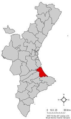
Safor (Valencian pronunciation: [saˈfoɾ]) is a comarca within the province of Valencia, Spain. The capital is the city of Gandia, but also includes the towns of Oliva, Piles and Daimús, among others. The beach area of Gandia, La Platja, is well known for its wild nightlife during the summer.
The former natural and historical comarca of Valldigna has been integrated into Safor comarca for administrative purposes.[1]
Disambiguation: See also Safor (designer).
Municipalities
- Ador
- Alfauir
- Almiserà
- Almoines
- L'Alqueria de la Comtessa
- Barx
- Bellreguard
- Beniarjó
- Benifairó de la Valldigna
- Beniflá
- Benirredrà
- Castellonet de la Conquesta
- Daimús
- La Font d'En Carròs
- Gandia
- Guardamar de la Safor
- Llocnou de Sant Jeroni
- Miramar
- Oliva
- Palma de Gandia
- Palmera
- Piles
- Potries
- Rafelcofer
- Real de Gandia
- Ròtova
- Simat de la Valldigna
- Tavernes de la Valldigna
- Villalonga
- Xeraco
- Xeresa
Climate
The predominant climate in La Safor is mediterranean-subtropical (Köppen climate classification: CSa) with very mild temperatures during winters, and hot summers. The annual average temperature depends on the zone, different temperature ranges occur near the sea to the mountains inland. Near the sea the average annual temperature is about 18-20ºC while in the interior the average annual temperatures are about 17-18ºC. Almost all of the cultivars in this zone are oranges and tangerines, so the majority of the zones are frostless. The rain quantity are different, with zones that can be considered as subtropical semi-arid BSh climates, and others that pertain to the CSa mediterranean climate with hot summers. The wettest season is the autumn. Climate data for Gandia:
| Climate data for Meteorological station of the beach of Gandía, Valencia province, Spain.) | |||||||||||||
|---|---|---|---|---|---|---|---|---|---|---|---|---|---|
| Month | Jan | Feb | Mar | Apr | May | Jun | Jul | Aug | Sep | Oct | Nov | Dec | Year |
| Record high °C (°F) | 29.6 (85.3) |
29.8 (85.6) |
34.2 (93.6) |
32.4 (90.3) |
40.4 (104.7) |
40 (104) |
39.7 (103.5) |
40.8 (105.4) |
38.3 (100.9) |
38.1 (100.6) |
33.1 (91.6) |
26.1 (79) |
40.8 (105.4) |
| Average high °C (°F) | 19.68 (67.42) |
19.03 (66.25) |
21.07 (69.93) |
23.35 (74.03) |
25.57 (78.03) |
29.28 (84.7) |
32.33 (90.19) |
32.05 (89.69) |
30.85 (87.53) |
28.79 (83.82) |
22.32 (72.18) |
19.26 (66.67) |
25.298 (77.537) |
| Daily mean °C (°F) | 14.37 (57.87) |
14.27 (57.69) |
15.91 (60.64) |
18.30 (64.94) |
18.90 (66.02) |
23.95 (75.11) |
27.03 (80.65) |
27.02 (80.64) |
25.82 (78.48) |
23.17 (73.71) |
17.82 (64.08) |
13.54 (56.37) |
20.008 (68.017) |
| Average low °C (°F) | 9.06 (48.31) |
9.5 (49.1) |
10.77 (51.39) |
13.26 (55.87) |
14.69 (58.44) |
18.63 (65.53) |
21.74 (71.13) |
21.99 (71.58) |
20.8 (69.4) |
17.45 (63.41) |
13.3 (55.9) |
8.09 (46.56) |
14.94 (58.885) |
| Record low °C (°F) | 3.1 (37.6) |
2.2 (36) |
3.9 (39) |
7.7 (45.9) |
8.4 (47.1) |
14 (57) |
17.9 (64.2) |
17.3 (63.1) |
14.8 (58.6) |
7 (45) |
4 (39) |
2.4 (36.3) |
2.2 (36) |
| Average precipitation days | 4 | 3 | 4 | 4 | 4 | 2 | 1 | 1 | 3 | 4 | 4 | 4 | 38 |
| Average snowy days | 0 | 0 | 0 | 0 | 0 | 0 | 0 | 0 | 0 | 0 | 0 | 0 | 0 |
| Source: The information for the extreme temperatures are for the last 3 years.[2] The rain data are for the nearest station which records rain data to Gandía, because the weather station of Gandia only records temperatures.[3] | |||||||||||||
References
- ↑ Valldigna website
- ↑ http://www.wunderground.com/personal-weather-station/dashboard?ID=IVALENCI47#history/s20120401/e20150501/mcustom
- ↑ - Estación climática de la Playa de Gandía (Weather Underground) y yr.no
See also
External links
Coordinates: 38°58′32″N 0°12′51″W / 38.9756°N 0.214061°W