Sabaragamuwa Province
| Sabaragamuwa Province සබරගමුව පළාත சபரகமுவ மாகாணம் | ||
|---|---|---|
| Province | ||
| ||
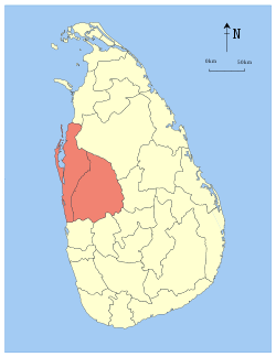
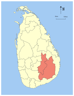
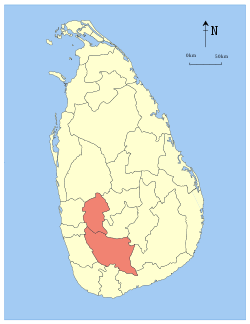 Location within Sri Lanka | ||
| Country | Sri Lanka | |
| Created | 1889 | |
| Admitted | 14 November 1987 | |
| Capital | Ratnapura | |
| Largest city | Ratnapura | |
| Government | ||
| • Governor | W. J. M. Lokubandara | |
| • Chief Minister | Maheepala Herath | |
| Area | ||
| • Total | 4,968 km2 (1,918 sq mi) | |
| Area rank | 8th (7.46% of total area) | |
| Population (2011 census) | ||
| • Total | 1,918,880 | |
| • Rank | 5th (9.63% of total pop.) | |
| • Density | 390/km2 (1,000/sq mi) | |
| Gross Regional Product (2010)[1] | ||
| • Total | Rs 303 billion | |
| • Rank | 5th (6.3% of total) | |
| Time zone | Sri Lanka (UTC+05:30) | |
| ISO 3166 code | LK-9 | |
| Vehicle registration | SG | |
| Official Languages | Sinhalese, Tamil | |
| Website |
www | |
.PNG)
The Sabaragamuwa Province, (Sinhalese: සබරගමුව පළාත Sabaragamuwa Palata, Tamil: சபரகமுவ மாகாணம் Sabaragamuwa Maakaanam) is one of the nine provinces of Sri Lanka, the first level administrative division of the country. The provinces have existed since the 19th century but did not have any legal status until 1987 when the 13th Amendment to the Constitution of Sri Lanka established provincial councils.[2][3] The Sabaragamuwa Province contains two districts: Ratnapura and Kegalle. It is named after its former indigenous inhabitants, namely the Sabara, an indic term for hunter-gatherer tribes, a term seldom used in ancient Sri Lanka. Sabaragamuwa University is in Belihuloya.
Districts
Sabaragamuwa is divided into 2 districts:
- Kegalle District 1,693 km2 (654 sq mi)
- Ratnapura District 3,275 km2 (1,264 sq mi)
Municipal Council
Urban Council
Other Towns
- Belihuloya
- Eheliyagoda
- Kalawana
- Pelmadulla
- Nivitigala
- Kuruwita
- Mawanella
- Yatiyantota
- Aranayake
- Kahawatte
- Rakwana
- Imbulpe
- Deraniyagala
- Ruwanwella
- Warakapola
- Ayagama
- Ambepussa
- Galigomuwa
- Rambukkana
- Bulathkohupitiya
- Karawanella
- Kitulgala
- Godakawela
- Kolonne
- Opanayaka
- Panamure
- Kiriella
- Balangoda
Ratnapura
At an elevation of approximately 500 feet above sea level, Ratnapura is the provincial capital of Sabargamuwa. It is 60 miles (100 km) from the city of Colombo.
See also
References
External links
 |
Western Province | North Western Province | Central Province | |
| Western Province | |
Central Province | ||
| ||||
| | ||||
| Southern Province | Southern Province | Uva Province Southern Province |


Coordinates: 6°40′N 80°24′E / 6.667°N 80.400°E