Sa'sa'
| Sa'sa' | |
|---|---|
|
IDF soldiers in Sa'sa', 30 October 1948 | |
 Sa'sa' | |
| Arabic | سعسع |
| Name meaning | from personal name[1] |
| Subdistrict | Safad |
| Coordinates | 33°01′43.39″N 35°23′39.82″E / 33.0287194°N 35.3943944°ECoordinates: 33°01′43.39″N 35°23′39.82″E / 33.0287194°N 35.3943944°E |
| Palestine grid | 187/270 |
| Population | 1,130 (1945) |
| Area | 14,796 dunams |
| Date of depopulation | 30 October 1948[2] |
| Cause(s) of depopulation | Military assault by Yishuv forces |
| Secondary cause | Expulsion by Yishuv forces |
| Current localities | Sasa[3] |

Sa'sa' (Arabic: سعسع, Hebrew: סעסע) was a Palestinian village, located 12 kilometres northwest of Safed that was depopulated by Israeli forces during the 1948 Arab-Israeli war. The village suffered two massacres committed by Haganah forces: one in mid-February 1948 and the other at the end of October the same year.[4][5][6] Its place has been taken since 1949 by Sasa, an Israeli kibbutz.
History
Sa'sa' was built on the site of a Bronze Age (early second millennium B.C.) settlement whose remains (walls, tombs, cisterns, and olive and wine presses), have been unearthed. One village house had foundations which has been dated back to fourth century by archaeologists.[4] Another excavated in 2003 yielded ceramics dated to the fourteenth–fifteenth centuries CE.[7]
The Arab geographer Abū 'Ubayd 'Abd Allāh al-Bakrī (d.1094) reported that one passed through Sa'sa' when travelling from Dayr al-Qasi to Safad.[4]
Ottoman era
In 1516 Sa'sa', with the rest of Palestine, came under the control of the Ottoman Empire. Shortly after, Sa'sa' was made a checkpoint where a toll was collected on various goods and travellers; the first records of such taxes are from 1525/6.[8]
In 1596 Sa'sa' was classified as a village in the nahiya ("subdistrict") of Jira, part of liwa' ("district") of Safad, with a population of 457. It paid taxes on wheat, barley, olives and fruits, as well as on goats, beehives, and vineyards.[9] According to this daftar, there were no non-Muslim inhabitants in the village.[10] In the eighteenth century Sa'sa' in mentioned as one of the fortified villages of Galilee controlled by Zahir al-Umar's son, Ali. After the defeat of Zahir al-Umar in 1775 Ali continued to resist the Ottoman authorities and defeated an army sent against him at Sa'sa'.[11]
In the late nineteenth century, Sa'sa' was described as a village with a population of 300, built on a slight hill that was surrounded by vineyards and olive and fig trees.[12]
Bristish Mandate era
In the 1922 census of Palestine conducted by the British Mandate authorities, Sa'sa had a population of 634; all Muslim.[13] increasing in the 1931 census to 840, still all Muslims, in a total of 154 houses.[14]
The village had a small market-place in the village center with a few shops, as well as a mosque and two elementary schools, one for girls and one for boys. In 1944/45 the village, with a population of 1,130, used 4,496 dunums for cereals; 1,404 dunums were irrigated or used for orchards.[4]
1948, and after
In February 1948, Yigal Allon, commander of the Palmach in the north, ordered an attack on Sa'sa'. The order was given to Moshe Kelman, the deputy commander of Third Battalion. The order read: "You have to blow up twenty houses and kill as many warriors as possible".[15][16] According to Pappé, the quote says which said "warriors" should be read "villagers".[15] Khalidi, referencing "The History of the Haganah" by Ben-Zion Dinur, say they referred to the massacre as "one of the most daring raids into enemy territory."[16]
One history of 1948 asserts that the reason for the attack was to restore Jewish public confidence in their fighting forces following the deaths of all the members of a platoon attempting to take supplies to Kfar Etzion a month previously.[17]
On February 15, 1948, a Palmach unit entered the village during the night and, without resistance, planted explosives against some of the houses. It was reported at the time that ten or more houses were totally or partially destroyed and 11 villagers were killed (5 of them small children).[18] According to the official history of the Haganah, the village had been used as a base for Arab fighters.[16] However, press reports at the time belie this, since the Palmach units met "without opposition" in the village.[16] According to Benvenisti (who gives the date of the attack as 14 February), the Palmach units that raided Sa'sa' killed 60 people and demolished 16 houses.[19]
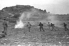
It was not until October 30, 1948, as part of Operation Hiram, that the forces of the Haganah occupied Sa'sa'. Those villagers who had not already fled were expelled. There are also allegations of war crimes at this time. Northern Command OC Moshe Carmel later reported that he had seen evidence of killings, and an official investigation by Major Emanuel Yalan suggested that some villagers, including cripples, may have been killed after the village was occupied. However, the relevant files remain closed to historians.[20]
Currently, there are few remains of the Palestinian village of Sa'sa', with the exception of the village mosque, which has now been converted into the Kibbutz museum. Excavations in 1972 on the west side of the hill revealed the remains of a large rectangular structure (15m x 41 m) with 2m thick walls made out of rubble stone with ashlar facing. At the south-west corner of the building there was a solid semi-circular tower (diameter 7m). The main part of the structure is a rectangular hall divided into two rows of five bays. There was a central row of four piers and two half-piers which would probably have supported a cross-vaulted roof. In a later phase an outer skin (2m wide) was added, making the wall a total of 4m thick. At the same time the round tower was converted into a square plan. According to the excavators, the place was occupied for a "fairly long" period, and suggest that it was probably part of the fortress built by Ali, (son of Zahir al-Umar) in the eighteenth century.[21] The design of the building is quite compatible with other fortresses of the period, like Qalat Jiddin and Dayr Hanna.[10]
In 1992, the Palestinian historian Walid Khalidi described the remains of the village: "Some of the old olive trees remain, and a number of walls and houses still stand. Some of the houses are presently used by the kibbutz; one of them has an arched entrance and arched windows. A large portion of the surrounding land is forested, the rest is cultivated by Israeli farmers."[22]
See also
- List of Arab towns and villages depopulated during the 1948 Arab-Israeli War
- Killings and massacres during the 1948 Palestine War
References
- ↑ Palmer, 1881, p. 93, see also p. 70
- ↑ Morris, 2004, p. xvi, village #60. Also gives causes of depopulation.
- ↑ Morris, 2004, p. xxi, Settlement #51, established January 1949.
- 1 2 3 4 Khalidi, 1992, p. 495
- ↑ Pappé, 2006, p. 77 ff.
- ↑ Benvenisti, 2000, p. 153
- ↑ Bron, 2006, Sasa
- ↑ Cohen and Lewis, 1998, pp. 57, 58
- ↑ Hütteroth and Abdulfattah, 1977, p. 176. Quoted in Khalidi, 1992, p. 495
- 1 2 Petersen, 2001, p.274
- ↑ Cohen, 1973, p. 93, 97. Cited in Petersen, 2001, p.274
- ↑ Conder and Kitchener, 1881, SWP I, p. 200. Quoted in Khalidi, 1992, p.495
- ↑ Barron, 1923, Table XI, Sub-district of Safad, p. 41
- ↑ Mills, 1932, p. 110
- 1 2 Pappe, 2006, p. 77
- 1 2 3 4 Khalidi, 1992, p. 496
- ↑ Kurzman, Don (1970) Genesis 1948. The First Arab-Israeli War. An Nal Book, New York. Library of Congress number 77-96925. p.53
- ↑ New York Times, Feb 16, 1948. Also cited in Khalidi, 1992, p. 496.
- ↑ Benvenisti, 2000, p. 107
- ↑ Morris, 2004, pp. 481, 501, 503
- ↑ Gibson and Braun, 1972. Cited in Petersen, 2001, p. 274
- ↑ Khalidi, 1992, p. 497
Bibliography
| Wikimedia Commons has media related to Sa'sa'. |
- Barron, J. B., ed. (1923). Palestine: Report and General Abstracts of the Census of 1922. Government of Palestine.
- Bron, Hendrik (Enno) (2006-12-10). "Sasa l Report" (118). Hadashot Arkheologiyot – Excavations and Surveys in Israel.
- Bron, Hendrik (Enno) (2013-04-02). "Sasa, Final report l Report" (125). Hadashot Arkheologiyot – Excavations and Surveys in Israel.
- Benvenisti, Meron (2000). Sacred Landscape: The Buried History of the Holy Land Since 1948. Maxine Kaufman-Lacusta (translator). University of California Press. ISBN 0-520-92882-2.
- Cohen, Amnon (1973). Palestine in the Eighteenth Century: Patterns of Government and Administration. Jerusalem: Hebrew University. Cited in Petersen, (2001)
- Cohen, Amnon; Lewis, Bernard (1978). Population and Revenue in the Towns of Palestine in the Sixteenth Century. Princeton University Press. ISBN 0-691-09375-X.
- Conder, Claude Reignier; Kitchener, Herbert H. (1881). The Survey of Western Palestine: Memoirs of the Topography, Orography, Hydrography, and Archaeology. 1. London: Committee of the Palestine Exploration Fund. (p. 256)
- Gibson, S and Braun, E. (1972) Sa'sa', HA, 63-64, pp 11–12 (in Hebrew). Cited in Petersen, 2002
- Guérin, Victor (1880). Description Géographique Historique et Archéologique de la Palestine (in French). 3: Galilee, pt. 2. Paris: L'Imprimerie Nationale. (pp. 93-94)
- Hadawi, Sami (1970). Village Statistics of 1945: A Classification of Land and Area ownership in Palestine. Palestine Liberation Organization Research Center.
- Hütteroth, Wolf-Dieter; Abdulfattah, Kamal (1977). Historical Geography of Palestine, Transjordan and Southern Syria in the Late 16th Century. Erlanger Geographische Arbeiten, Sonderband 5. Erlangen, Germany: Vorstand der Fränkischen Geographischen Gesellschaft. ISBN 3-920405-41-2.
- Khalidi, Walid (1992). All That Remains:The Palestinian Villages Occupied and Depopulated by Israel in 1948. Washington D.C.: Institute for Palestine Studies. ISBN 0-88728-224-5.
- Mills, E., ed. (1932). Census of Palestine 1931. Population of Villages, Towns and Administrative Areas. Jerusalem: Government of Palestine.
- Morris, Benny (2004). The Birth of the Palestinian Refugee Problem Revisited. Cambridge University Press. ISBN 978-0-521-00967-6.
- Nazzal, Nafez (1978). The Palestinian Exodus from Galilee 1948. The Institute for Palestine Studies. (Sa'sa' pp. 46, 95)
- Palmer, E. H. (1881). The Survey of Western Palestine: Arabic and English Name Lists Collected During the Survey by Lieutenants Conder and Kitchener, R. E. Transliterated and Explained by E.H. Palmer. Committee of the Palestine Exploration Fund.
- Pappé, Ilan (2007). The ethnic cleansing of Palestine. (reprint). Oneworld Publications Limited. ISBN 978-1-78074-056-0.
- Petersen, Andrew (2001). A Gazetteer of Buildings in Muslim Palestine (British Academy Monographs in Archaeology). 1. Oxford University Press. ISBN 978-0-19-727011-0.
- Smithline, Howard (1997). "Sasa, West l Report" (16). Hadashot Arkheologiyot – Excavations and Surveys in Israel.
- Syon, Danny; Nagar, Yossi (2014-09-08). "Sasa, Final report l Report" (126). Hadashot Arkheologiyot – Excavations and Surveys in Israel.
- Robinson, Edward; Smith, Eli (1841). Biblical Researches in Palestine, Mount Sinai and Arabia Petraea: A Journal of Travels in the year 1838. 3. Boston: Crocker & Brewster. (pp. 368-369)
External links
- Palestine Remembered - Sa'sa'
- Survey of Western Palestine, map 4: IAA, Wikimedia commons
- Sa'sa', the Khalil Sakakini Cultural Center
- Sa3sa3, Dr. Moslih Kanaaneh
- Sa’sa’, Dr. Khalil Rizk.