Saône
| Saône (La Saône) | |
| Sona | |
| River | |
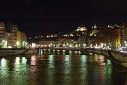 The Saône in Lyon by night. | |
| Country | France |
|---|---|
| Tributaries | |
| - left | Doubs, Lanterne |
| - right | Azergues, Morgon |
| Source | Vioménil |
| - location | Vosges |
| - elevation | 392 m (1,286 ft) |
| - coordinates | 48°05′40″N 6°10′55″E / 48.094444°N 6.181944°E |
| Mouth | Rhône |
| - location | Lyon, France |
| - elevation | 158 m (518 ft) |
| - coordinates | 45°43′39″N 4°49′4″E / 45.72750°N 4.81778°ECoordinates: 45°43′39″N 4°49′4″E / 45.72750°N 4.81778°E |
| Length | 473 km (294 mi) |
| Area | 29,950 km2 (11,564 sq mi) |
| Discharge | |
| - average | 410 m3/s (14,479 cu ft/s) |
The Saône (French: La Saône French pronunciation: [soːn];[1] Arpitan Sona, Latin: Arar) is a river of eastern France. It is a right tributary of the Rhône, rising at Vioménil in the Vosges department and joining the Rhône in Lyon, just south of the Presqu'île.
The name "Saône" derives from that of the Gallic river goddess Souconna, which has also been connected with a local Celtic tribe, the Sequanes. Monastic copyists progressively transformed "Souconna" to "Saoconna", which ultimately gave rise to "Saône". The other recorded ancient names for the river were Brigoulus and Arar.
Geography
The Saône rises at Vioménil at the foot of the cliff of the Faucilles in the Vosges at an elevation of 392 metres (1,286 ft), and flows into the Rhône at Lyon at an elevation of 158 metres (518 ft). Its length is 480 kilometres (300 mi).[2] Its largest tributary is the Doubs; upstream of receiving the Doubs at Verdun-sur-le-Doubs in Saône-et-Loire, the Saône is called the "Petite Saône" (lesser Saône), which reflects the large contribution of the Doubs to the Saône. In fact the Doubs' mean annual flow rate is slightly stronger than that of the Petite Saône, 175 cubic metres per second (6,200 cu ft/s) compared to 160 cubic metres per second (5,700 cu ft/s); some thus assert that it is in fact the Saône that flows into the Doubs. Nonetheless the Saône has a substantially larger watershed than the Doubs, at 11,500 square kilometres (4,400 sq mi) vs. 7,500 square kilometres (2,900 sq mi).
At 30,000 square kilometres (12,000 sq mi) the Saône has the largest watershed of any French river that does not flow directly into the sea, covering approximately 1/18 of metropolitan France.
In pre-Roman times the river's name was "Arar", a doubling of the Indo-European root ar (water). According to Caesar's Gallic Wars this doubling reflected the idea that it was difficult to identify the direction of the river due to its slow rate of flow. Its current name came from a sacred spring, Sauc-Onna, located at Chalon, which was used by Roman legionnaries to refer to the entire river.
Departments and cities traversed by the Saône
_-_carte.png)

- Vosges: Darney, Monthureux-sur-Saône, Châtillon-sur-Saône
- Haute-Saône: Jonvelle, Corre, Jussey, Port-sur-Saône, Scey-sur-Saône, Gray
- Côte-d'Or: Auxonne, Saint-Jean-de-Losne, Seurre
- Saône-et-Loire: Verdun-sur-le-Doubs, Chalon-sur-Saône, Tournus, Mâcon, Crêches-sur-Saône
- Rhône: Belleville-sur-Saône, Villefranche-sur-Saône, Anse, Neuville-sur-Saône, Fontaines-sur-Saône, Caluire-et-Cuire, Lyon
- Ain: Thoissey, Jassans-Riottier, Trévoux
Main tributaries of the Saône
R indicates a right tributary, L indicates a left tributary.
|
Navigation

The Saône is classed as navigable after its confluence with the Côney at Corre in the north of Haute-Saône all the way to its confluence with the Rhône (itself a navigable river) at la Mulatière, in Lyon. The navigable stretch is over 365 kilometres (227 mi) long, of which 167 kilometres (104 mi) is European large gauge (from Verdun-sur-le-Doubs to Lyon).
The Saône is linked with the Loire by the Canal du Centre, with the Yonne by the Canal de Bourgogne, with the Marne by the Canal entre Champagne et Bourgogne (previously the Canal de la Marne à la Saône), with the Meuse by the Canal de l'Est, whose southern branch has been renamed the Canal des Vosges, and with the Rhine by the Canal du Rhône au Rhin. All the canals are Freycinet gauge.
Also navigable are the small Canal de Pont-de-Vaux (3 km), the Seille, navigable in a 40-kilometre (25 mi) stretch up to Louhans, and the lower part of the Doubs. None of these three connect the Saône to any other body of water, however.
Hydrology
The lesser Saône


The lesser Saône has a tendency to flood (sometimes influenced by snow), with a very strong oceanic effect. The soils are not susceptible to much infiltration, so that they saturate quickly which contributes to surface runoff. The flow rate grows very quickly, and after receiving the waters of the Lanterne, the Saône already becomes a powerful river.
The mean annual flow rate, or discharge, of the Saône has been measured over 50 years (as of 2013) at the Ray-sur-Saône hydrological station, situated about 30 kilometres (19 mi) after the Lanterne confluence between Port-sur-Saône and Gray. The figure is 59.7 cubic metres per second (2,110 cu ft/s) for a watershed area of 3,740 square kilometres (1,440 sq mi) (the upper basin of the lesser Saône), and has an annual maximum of 64.5 cubic metres per second (2,280 cu ft/s) and a minimum of 54.8 cubic metres per second (1,940 cu ft/s).
The river exhibits seasonal variations in flow rate, with winter floods from 84 to 108 cubic metres per second (3,000 to 3,800 cu ft/s) from December to March inclusive, and summer reductions in July/August/September falling to a monthly average of 16.9 cubic metres per second (600 cu ft/s) in August.[3]
The runoff curve number in the upper basin of the lesser Saône is 505 millimetres (19.9 in) annually, cf. 687 millimetres (27.0 in) for the Lanterne, an elevated figure resulting from the very high rainfall in the Vosgian part of its watershed. The specific flow rate rises to 16.0 litres per second per square kilometre of watershed.
The maximum instantaneous recorded flow rate was 930 cubic metres per second (33,000 cu ft/s) on December 19, 1982.
The greater Saône
The greater Saône is formed by the confluence of the Doubs and the lesser Saône at Verdun-sur-le-Doubs. The Doubs brings a mean annual flow rate of 175 cubic metres per second (6,200 cu ft/s), and the lesser Saône, 160 cubic metres per second (5,700 cu ft/s).
The greater Saône has only modest tributaries which have little effect on floods or other hydrological properties. It flows in a vast plain approximately 3 kilometres (2 mi) wide as far as Lyon in the basin of the former Bressan lake. The slope is very gradual, and without hydraulic projects up to the north of Chalon aimed at guaranteeing a deep navigation channel, overflows would be more frequent.
At the Couzon-au-Mont-d'Or hydrological station, where the river enters the Lyon area, measurements taken between 1969 and 1986 revealed a mean annual flow rate of 473 cubic metres per second (16,700 cu ft/s), with a 100-year flood flow rate of 3,180 cubic metres per second (112,000 cu ft/s)[4] The runoff curve number from the river's entire watershed is 501 millimetres (19.7 in), and the specific flow rate rises to 15.8 litres per second per square km of watershed.
Average flow rate
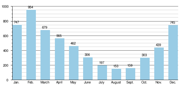
Overall, the average flow rate in Lyon is 475 cubic metres per second (16,800 cu ft/s), with a minimum of 153 cubic metres per second (5,400 cu ft/s), in August, and a maximum of 954 cubic metres per second (33,700 cu ft/s), in February.[5]
Historic floods
When the Saône floods, the impact varies considerably over the course of the river. A large flood with a strong flow rate upstream can be largely attenuated in the Bressan plain so as to have only moderate impact at Mâcon, particularly if it carries a limited volume of water. By contrast, a medium-sized flood of the lesser Saône can turn into a significant flood downstream, if the Doubs brings in a similar contribution at about the same time.
Historic floods include:
- The Lyon flood of 580
- The floods of 1602 during the autumn equinox[6] and of 1711
- The flood of November 1840, with an estimated flow rate of almost 4,000 cubic metres per second (140,000 cu ft/s), destroyed numerous habitations along the river valley. Many plaques marking this serious event are still visible in the villages affected. The high water measured at flood scales reached 8.05 metres (26.4 ft) at Mâcon and 7.28 metres (23.9 ft) at Chalon, or about 6 and 5.5 metres (20 and 18 ft) respectively above normal levels).
- The flood of May 1856
- The largest floods in the last 50 years as of 2006: January 1955, March 1970, December 1981 and 1982, May 1983, March 2001 and 2006.
The reference flood in town planning is the 100-year flood. This reference was in the course of being modified as maps linked to modelling the 1840 flood in modern town planning conditions were distributed to local mayors in December 2008, and as new prevention plans were ordered for 2012.
 A plaque commemorating the flood of 1840 at Quincieux
 Historic floods since 1950 Écuelles, north Saône-et-Loire
 Indicators of the level of historic floods of the Saône on the Church of Notre-Dame de Belleville
See also
- List of rivers in France
- The Rhône
- The Doubs
- Saône is also a French commune in the département of Doubs.
References
- ↑ (French) Jean-Marie Pierret, Phonétique historique du français et notions de phonétique générale, Peeters, Louvain-la-Neuve, 1994, p. 104.
- ↑ Sandre. "Fiche rivière la saône (U—0000)" (in French). Retrieved July 19, 2008.
- ↑ (French) Banque Hydro – Station U0610010 – La Saône à Ray-sur-Saône (Synthèse) (Do not tick the box "Station en service")
- ↑ (French) Drainage basin of the Saône
- ↑ (French) Banque Hydro – Station U4710010 – La Saône à Couzon-au-Mont-d'Or (Do not tick the box "Station en service")
- ↑ (French) Floods of the Rhône and all its tributaries, Volume 4
External links
| Wikimedia Commons has media related to Saône. |
- Navigation guide Places, ports and moorings on the Grande Saône from Maxilly to Lyon.
- Waterways in France
- (French) Saone.org : French river cruising
- The Saône on OpenStreetMap
- (French) Saone.org Navigation and information about the Saône
- (French) Dictionary of French rivers and canals on the Babel project: The Saône
- (French) Navigable routes in France