SEPTA Route 36
| SEPTA Route 36 SEPTA Subway–Surface Trolley Lines | |
|---|---|
 | |
|
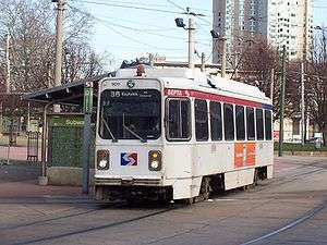
SEPTA Route 36 at the 40th Street Portal | |
| Overview | |
| System | Subway-Surface Trolley Lines |
| Termini |
Eastwick, Philadelphia Center City, Philadelphia |
| Stations | 11 |
| Operation | |
| Opened | 1904 |
| Depot(s) | Elmwood Carhouse |
| Technical | |
| Line length | 16.2 mi (26.1 km) |
| Track gauge | 5 ft 2 1⁄4 in (1,581 mm)[1][2] |
| Electrification | overhead lines |
SEPTA's Subway-Surface Trolley Route 36 (a.k.a.; the Elmwood Avenue-Subway Line) is a trolley line operated by the Southeastern Pennsylvania Transportation Authority (SEPTA) that connects the 13th Street station in downtown Philadelphia, Pennsylvania, to the Eastwick Loop station in Eastwick section of Southwest Philadelphia, although limited service is available to the Elmwood Carhouse. It is the longest of the five lines that are part of the Subway-Surface Trolley system, and was even longer between 1956 and 1962 when the western terminus was at 94th and Eastwick Place. From 1962 through the 1970s it was at 88th Street and Eastwick Place, making the route 16.2 miles (26.1 km) long.[3] Today, it only goes as far as what was once 80th Street.
Route description
Starting from its eastern end at the 13th Street, Route 36 runs in a tunnel under Market Street. It stops at underground stations at 15th Street, 19th Street, 22nd Street, 30th Street, and 33rd Street. From 15th to 30th Streets, it runs on the outer tracks in the same tunnel as SEPTA's Market–Frankford Line.
Passengers may transfer free of charge to the Market–Frankford Line at 13th, 15th, and 30th Streets and to the Broad Street Line at 15th Street. Connections to the SEPTA Regional Rail are also available. Underground passageways connect the 13th and 15th Street Stations to Jefferson Station and Suburban Station.
Route 36 surfaces at the 40th Street Portal near 40th Street and Baltimore Avenue (US 13), and then runs southwest along Woodland Avenue along with the Route 11 trolleys, and then turns down 49th Street where the Woodland Maintenance Facility is located and the Route 10 diversion line ends. After 49th Street crosses over the Wilmington/Newark Line, it takes a sharp right curve as the road becomes Grays Avenue. Route 36 runs along Grays south of the Wilmington/Newark Line until it makes a diagonal move southwest onto Lindbergh Boulevard. Shortly after leaving Grays the line intersects with 54th Street and crosses over a bridge for the Philadelphia Subdivision freight line, and immediately intersects with a road running along the line leading to Bartram's Botanical Garden, the oldest surviving botanical garden in North America.[4]
Just before Lindbergh Boulevard becomes a divided highway east of 56th Street, the line moves onto Elmwood Avenue. From there it crosses over the Airport Line, continuing westward until it enters an industrial area and makes a left turn at a five way intersection that includes Elmwood Avenue, Island Road and Passyunk Avenue on the southeast corner. The northeast corner is the location of the Elmwood Depot on Island Road. Tracks runs northward along Island Road as far north as Woodland Avenue, which handles pull-ins/pull-outs for Routes 11 & 13.
Island Road is a wide boulevard with the Route 36 tracks down the middle, until the road divides at Buist Avenue, where the tracks run down the median, and a trolley stop exists. Another stop exists at Tanager Street. South of Tanager Street, the southbound Island Avenue lane crosses over the tracks, and they now run between the main road and southbound frontage road. The next stop is South 76th Street, which intersects with the frontage road, but has a stop along both this and the main road. The Route 36 line crosses Lindbergh Boulevard again, where it has its own stop in the median on both sides of the tracks north of Lindbergh Boulevard. The southwest corner also includes the Penrose Plaza Shopping Center, which spans the west side of Island Road as far down as the terminus of the Route 36 line, the Eastwick Loop, which is accessible from a U-Turn beneath the Island Road bridge over the SEPTA Airport Line, and is four blocks east of Eastwick Railroad Station. SEPTA plans to expand the regional rail station and possibly merge it with the trolley station, transforming it into the Eastwick Transportation Center.[5]
History
Route 36 was established as the Elmwood Avenue Line in 1904 by the Philadelphia Rapid Transit Company. Original streetcar service operated between Island Road and Elmwood Avenue via Center City on Market Street to Front & Market Streets. Service rerouted into the Subway-Surface Tunnel and extended to the Westinghouse Plant in Essington on November 5, 1955 replacing Route 37 trolley service. OWL (24-hour) service transferred from Route 37 to Route 36 at the same time. At the western terminus, service was cut back to 94th Street & Eastwick Avenue on September 9, 1956. Service was cut back again to 88th Street & Eastwick Avenue on August 15, 1962, Service was cut back a third time to 84th Street & Eastwick Avenue on January 5, 1966, but extended back to 88th Street & Eastwick Avenue on December 11, 1972. Service was cut back to 80th Street & Eastwick Avenue (Intersection no longer exists; today's current trolley loop is located at or near this location) on April 26, 1975. In 1985, Island Avenue was converted into a new bridge over the SEPTA Airport Line near the station, and the intersection of 80th Street and Eastwick Avenue was replaced by a frontage road loop on the north side of the tracks.[6]
Stations
All stations are in Philadelphia.
| Station | Other Lines | Notes |
|---|---|---|
| 13th Street | 10, 11, 13, 34 |
|
| 15th Street | 10, 11, 13, 34 |
|
| 19th Street | 10, 11, 13, 34 | |
| 22nd Street | 10, 11, 13, 34 |
|
| 30th Street | 10, 11, 13, 34 |
|
| 33rd Street | 10, 11, 13, 34 |
|
| Sansom Commons/36th Street | 11, 13, 34 |
|
| 37th/Spruce | 11, 13, 34 |
|
| 40th Street Portal | 11, 13, 34 |
|
| Elmwood Carhouse |
| |
| Eastwick Loop |
|
References
- ↑ "The history of trolley cars and routes in Philadelphia". SEPTA. 1974-06-01. p. 2. Retrieved 2014-06-11.
An early city ordinance prescribed that all tracks were to have a gauge of 2' 2 1⁄4"
- ↑ Hilton, George W.; Due, John Fitzgerald (2000-01-01). The Electric Interurban Railways in America. Stanford University Press. Retrieved 2014-06-10.
- ↑ 1974 SEPTA Trolleys Brochure
- ↑ Directions to Bartram's Garden (Official Site)
- ↑ SEPTA Regional Rail Lines (NYC Subways.org)
- ↑ ISLAND AVENUE over SEPTA; FRONTAGE ROAD - Philadelphia, Pennsylvania (UglyBridges.com)