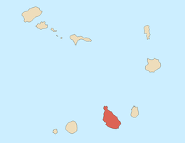
São Salvador do Mundo, Cape Verde
São Salvador do Mundo is a concelho (municipality) of Cape Verde. It is situated in the central part of the island of Santiago. Its seat is the town Picos. Its population was 8,643 at the 2010 census.[1]
Its current president represents the African Party for the Independence of Cape Verde (PAICV) since 2008.
Its rock formation located near Picos is around the area, the etymology can also refer to its nearby mountain range of Pico da Antónia, it includes parts of the eastern part of the ranges. The municipality has a dam named Faveta, completed in July 19, 2013 along with the island's other two dams.[2] When Hurricane Fred in August and September, its rains filled all of its dam to maximum capacity and prompted residents from adjacent areas to evacuate.[3]
The only football (soccer) club in the municipality is União dos Picos, based in the municipal seat but is the club of the whole municipality. The club is part of the Santiago Island League.
Subdivisions
The municipality consists of one freguesia (civil parish), São Salvador do Mundo. The freguesia are subdivided into the following settlements, its population data was of the 2010 census:
- Aboboreiro (pop: 532)
- Achada Leitão (pop: 1,160)
- Babosa (pop: 183)
- Burbur (pop: 131)
- Covão Grande (pop: 478)
- Degredo (pop: 148)
- Djéu (pop: 90)
- Faveta (pop: 247)
- Jalalo Ramos (pop: 239)
- Junco (pop: 266)
- Leitão Grande (pop: 927)
- Leitãozinho (pop: 460)
- Manhanga (pop: 177)
- Mato Fortes (pop: 179)
- Mato Limão (pop: 134)
- Pico Freire (pop: 546)
- Picos (Achada Igreja) (pop: 986)
- Picos Acima (pop: 1,489)
- Purgueira (pop: 217)
- Rebelo Acima (pop: 54)
History
_(2).jpg)
Area of the municipality west of the popular formation
It was created in 2005, when a parish of the older Municipality of Santa Catarina was separated to become the Municipality of São Salvador do Mundo.
In the 2008 municipal elections on May 18, its first municipal leaders were elected to the national level of each party, João Baptista Pereira to the Chamber, and Pedro Brito to the National Assembly.
Demography
| Population of São Salvador do Mundo (2000—2010) |
|---|
| 2000[4] |
2010[1] |
| 9214 |
8643 |
External links
References
|
|---|
|
| Barlavento Islands | |
|---|
|
| Sotavento Islands | |
|---|
_(3).jpg)