Rutledal
| Rutledal | |
|---|---|
| Village | |
|
View of the shoreline in Rutledal | |
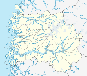 Rutledal  Rutledal Location in Sogn og Fjordane county | |
| Coordinates: 61°04′01″N 05°11′17″E / 61.06694°N 5.18806°ECoordinates: 61°04′01″N 05°11′17″E / 61.06694°N 5.18806°E | |
| Country | Norway |
| Region | Western Norway |
| County | Sogn og Fjordane |
| District | Sogn |
| Municipality | Gulen Municipality |
| Elevation[1] | 59 m (194 ft) |
| Time zone | CET (UTC+01:00) |
| • Summer (DST) | CEST (UTC+02:00) |
| Post Code | 5966 Eivindvik |
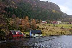
Rutledal is a village in Gulen Municipality in Sogn og Fjordane county, Norway. The village is located at the mouth of the Sognefjorden, on the south side on the mainland. Rutledal is has a ferry quay that has regular connections to the island municipality of Solund to the northwest and to Hyllestad Municipality on the mainland across the fjord to the north. Rutledal is located about 20 kilometres (12 mi) to the northwest of the village of Brekke and about 15 kilometres (9.3 mi) to the north of the municipal centre of Eivindvik.[2]
Rutledal is a rural village sitting at the northern end of a narrow, forested valley. The Rutledal area has a number of farms that have been cleared of trees, although not all are currently in use. For a time, Rutledal had a small store and a post office.
References
- ↑ "Rutledal, Gulen" (in Norwegian). yr.no. Retrieved 2014-01-15.
- ↑ Store norske leksikon. "Rutledal" (in Norwegian). Retrieved 2014-01-15.