Rutgers Glacier
| Rutgers Glacier | |
|---|---|
|
Map depicting the location of Rutgers Glacier in Victoria Land, Antarctica | |
| Coordinates | 78°14′00″S 161°55′00″E / 78.23333°S 161.91667°ECoordinates: 78°14′00″S 161°55′00″E / 78.23333°S 161.91667°E |
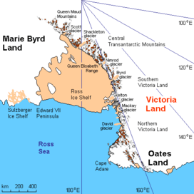
Rutgers Glacier (78°14′S 161°55′E / 78.233°S 161.917°E) is a steep glacier on the west side of the Royal Society Range in the Ross Dependency, Antarctica. Rutgers Glacier descends southwest from Johns Hopkins Ridge and Mount Rucker to enter the Skelton Glacier.[1] Abbott Spur separates the lower ends of Rutgers Glacier from Allison Glacier.[2]
Discovery and naming
Rutgers Glacier was mapped by the United States Geological Survey (USGS) from ground surveys and aerial photographs taken by the United States Navy. The glacier was named by the Advisory Committee on Antarctic Names (US-ACAN) after Rutgers University, New Brunswick, New Jersey, which has sent researchers to Antarctica, and in association with Johns Hopkins Ridge and Carleton Glacier.[1]
References
- 1 2 "Rutgers Glacier". Geographic Names Information System. United States Geological Survey. Retrieved 2011-05-13.
- ↑ "Abbott Spur". Geographic Names Information System. United States Geological Survey. Retrieved 2011-05-13.
| General | .svg.png) | |
|---|---|---|
| Geographic regions | ||
| Waterways | ||
| Famous explorers | ||
![]() This article incorporates public domain material from the United States Geological Survey document "Rutgers Glacier" (content from the Geographic Names Information System).
This article incorporates public domain material from the United States Geological Survey document "Rutgers Glacier" (content from the Geographic Names Information System).