Russia–Ukraine border

The Russian-Ukrainian border is the international state border between Russia and Ukraine, which formally has been in existence since Ukraine's independence from the Soviet Union, on August 24, 1991. Over land the border outlines five oblasts (regions) of Ukraine and five oblasts of the Russian Federation.
Since the spring of 2014 the border has been compromised due to the 2014–present Russian military intervention in Ukraine. According to head of the State Border Guard Service of Ukraine Viktor Nazarenko Ukraine doesn't control 409.3 kilometers of the state border.[1] This stretch of land is now controlled by the Donetsk People's Republic and Luhansk People's Republic.[2]
In 2014, the Ukrainian government unveiled a plan to build a defensive walled system along the border with Russia, named "Project Wall". It would cost almost $520 million, take four years to complete and has been under construction as of 2015.[3]
History
The border has inherited its location from the administrative territorial division between the Ukrainian SSR and the Russian SFSR. The first real demarcation took place in May 1918 in Kursk.[4] After the fall of the Russian Empire, most of Ukraine (Ukrainian People's Republic) was overran by Red Guards of the Soviet Russia. With the help of Central Powers, Ukraine managed to recover all its territories of "Ukrainian governorates" and also annexed number of neighboring counties of Kursk and Voronezh governorates where ethnic composition of population was predominantly Ukrainophone (Ukrainian speaking).[5] On May 6, 1918 a ceasefire agreement was signed in Konotop between Ukraine and the Soviet Russia.[4] Between the fighting sides was created a neutral territory between 10–40 km wide to prevent further aggression, yet the Russian side decided to create some guerrilla forces which were transformed in two "Ukrainian divisions"[4] (see Nikolay Shchors).
Peace talks started on May 23, 1918 in Kiev where the Russian delegation was headed by Christian Rakovsky and Dmitry Manuilsky, while the Ukrainian - by Serhiy Shelukhin (Ambassador of Ukraine to Russia).[4] On June 12, 1918 the sides signed the preliminary peace treaty.[4] Further negotiations stalled due to lack of consensus on issue of the border.[4] The Ukrainian side was proposing an ethnic principle based on the already established political, geographical and economic aspects, while the Russian side insisted on conducting a plebiscite in each populated place.[4] On June 22, 1918 both sides finally agreed to go along with the Ukrainian proposition, while any contested issues would be decided by plebiscite.[4] Yet any further negotiations led nowhere and were terminated by the Ukrainian delegation in October 1918 as it was becoming apparent that the Russian was using their time more for the pro-Soviet propaganda.[4]
More productive were negotiations between the Don Republic and Ukraine that started their negotiations soon after the Don Republic formed its government on May 16, 1918.[4] The Don side was presented by the Minister of trade Vladimir Lebedev and the Ambassador of Don to Ukraine General Aleksandr Cheriachukin, while the Ukrainian side - by the Minister of Foreign Affairs Dmytro Doroshenko.[4] On August 8, 1918 the sides signed the treaty "About basic principles of bilateral relations" where every side agreed to renounce its territorial contests against each other and border was established based on the gubernatorial division of the Russian Empire.[4] The Don-Ukraine border outlined the Oblast of Don Host to the west of Don Republic and Yekaterinoslav, Kharkiv, Voronezh guberniyas to the east of Ukraine.[4] To Ukraine also was ceded some territory of right bank Kalmius river just east of Mariupol "to ensure the proper administration of the city and port".[4] On September 18, 1918 between Don and Ukraine was created Don-Ukrainian Commission in administration of the Taganrog Industrial District based in Kharkiv.[4]
After the second invasion of the Soviet troops in 1919, the new Soviet government of Ukraine intended to retain all territorial gains of the Ukrainian national government (Ukrainian State).[5] However, after several rounds of negotiations, the border between the "Ukrainian governorates" (Chernihiv and Kharkiv) and the "Russian governorates" (Bryansk and Kursk) were left intact.[5] It also was agreed that Ukraine will border Crimea at the Perekop Isthmus.[5] On March 10, 1919 a border treaty was signed between the Russian SFSR and the Ukrainian SSR.[5]
On April 24, 1919 the Ukrainian SSR was stripped off four counties of the Chernihiv Governorate that on the unilateral decision of the People's Commissariat of Foreign Affaris of the Russian SFSR were transferred to the newly created Gomel Governorate.[5] On April 28, 1919 the Central Committee of the Communist Party of Ukraine simply acknowledged it.[5]
2014 Russian intervention in Ukraine
Since the March 2014 annexation of Crimea by Russia the status of the Crimea and of the city of Sevastopol is currently under dispute between Russia and Ukraine; Ukraine and the majority of the international community consider the Crimea to be an autonomous republic of Ukraine and Sevastopol to be one of Ukraine's cities with special status, while Russia, on the other hand, considers the Crimea to be a federal subject of Russia and Sevastopol to be one of Russia's three federal cities.[6][7] Since 1991 Russia also leases Sevastopol Naval Base with the current lease extending to the 2040s with an option for another extension, but the Russian State Duma approved the denunciation of this lease agreements unanimously by 433 members of parliament on 31 March 2014.[8] Borders of the Russian Naval Base in the city of Sevastopol and its vicinity has not been clearly identified.
Since the start of the War in Donbass in April 2014 Ukraine lost (according to head of the State Border Guard Service of Ukraine Viktor Nazarenko) control of 409.3 kilometers of the state border in southeastern Ukraine.[1][9] This stretch of land is now controlled by the Donetsk People's Republic and Luhansk People's Republic.[2]
According the State Border Guard Service of Ukraine the amount of Russian citizens who crossed the border with Ukraine (more than 2.5 million Russians in 2014) dropped by almost 50% in 2015.[10] They also refused entry into Ukraine to 16,500 citizens of Russia in 2014 and to 10,800 Russians in 2015.[11]
Geography
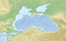
The border has a length of 2,295.04 kilometres (1,426.07 mi) of which 1,974.04 kilometres (1,226.61 mi) is land border and 321 kilometres (199 mi) is sea border. It extends from a point in the Black Sea 22.5 kilometres (14.0 mi) south of the Kerch Strait, where the first contact the territorial waters of both states, is to the north of this strait, passing it is on the Sea of Azov to the point on the coast which goes to the land border and so on to the tripoint with Belarus to the north.
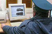
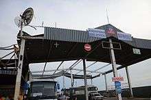
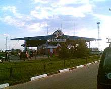
The Russia–Ukraine border has the biggest number of border checkpoints in Ukraine.
Demarcation
A treaty on the demarcation of the common border between the foreign ministers of Ukraine and Russia was signed on 17 May 2010 and came into force on 29 July of the same year.[12] At that time, Ukraine intended to start work on the demarcation of the border upon ratification of the agreement by the respective governments, but ratification was not completed. However 16 June 2014 the National Security and Defense Council of Ukraine ordered the government to carry a one-side demarcation of the border "in terms of existing threats to national security"; amidst the worst fighting of the 2014 pro-Russian conflict in Ukraine.[12]
Ukrainian Wall
Since May 2015 Ukraine is building a fortified border barrier on the Russia–Ukraine border. The aim of the project is preventing Russian military and hybrid warfare intervention in Ukraine.[13] As of May 2015, a walled defense system was under construction along the Russian border in Kharkiv Oblast.[3] The project is planned to be finished in 2018.[14]
Border checkpoints
Chernihiv – Bryansk
The section of the border between the Chernihiv Oblast and Bryansk Oblast has length of 183 km (114 mi).[15]
| Checkpoint | Status | Type | P/F |
|---|---|---|---|
| Hremiach – Pogar | international | (automobile) | P,F |
| Mykolayivka – Lomakovka | interstate | (automobile) | P,F |
| Senkivka – Novye Yurkovichi3 | international | (automobile) | P,F |
Notes:
- 3 – three-way checkpoint with Belarus
Sumy – Bryansk
| Checkpoint | Status | Type | P/F |
|---|---|---|---|
| Bachivsk – Troyebornoye | international | (automobile) | P,F |
| Zernove – Suzemka | international | (rail) | P,F |
Sumy – Kursk
| Checkpoint | Status | Type | P/F |
|---|---|---|---|
| Boyaro-Lezhachi – Tyotkino1 | local | (automobile, pedestrian) | P |
| Volfine – Glushkovo | interstate | (rail) | P,F |
| Volfyne – Volfino1 | local | (automobile, pedestrian) | |
| Katerynivka – Krupets | international | (automobile) | P,F |
| Kondrativka – Yelizovetovka1 | local | (automobile, pedestrian) | P |
| Novovasylivka – Belaya Beryozka1 | local | (automobile, pedestrian) | P |
| Ryzhivka – Tyotkino | interstate | (automobile) | P,F |
| Ryzhivka – Tyotkino | local | (automobile) | P |
| Seredyna-Buda – Zyornovo1, 2 | local | (automobile, pedestrian) | P |
| Starykove – Kozino1 | local | (automobile, pedestrian) | P |
| Yunakivka – Sudzha | international | (automobile) | P,F |
Notes:
- 1 – closed for nighttime
- 2 – under renovations
Sumy – Belgorod
| Checkpoint | Status | Type | P/F |
|---|---|---|---|
| Velyka Pysarivka – Graivoron | international | (automobile) | P, F |
| Hrabovske – Staroselye1 | local | (automobile, pedestrian) | P, F |
| Pokrovka – Kolotilovka | interstate/local | (automobile) | P, F |
| Pushkarne – Ilek-Penkovka | interstate | (rail) | P,F |
Notes:
- 1 – closed for nighttime
Kharkiv – Belgorod

- Budarky – Tishanka
- Vovchansk – Nezhegol
- Hoptivka – Nekhoteyevka
- Kozacha Lopan – Dolbino
- Kupyansk – Valuiki
- Odnorobivka – Golovchino
- Oleksandrivka – Bezymeno
- Pisky – Logachovka
- Pletenivka – Shebekino
- Strilecha – Zhuravlyovka
- Topoli – Valuiki
- Kharkiv-Passenger – Belgorod
- Kharkiv-Sorting – Belgorod
- Chuhunivka – Verigovka
Luhansk – Belgorod
- Dyomino-Oleksandrivka – Valuiki
- Lantrativka – Razyezd Vystrel
- Petrivka – Shiyany
- Syrotyne – Klimenki
- Tanyushivka – Rovenki
Luhansk – Voronezh
- Novobila – Novobelaya
- Prosyane – Bugayevka
Luhansk – Rostov
During the war in Donbass, the section of border operations was suspended.
- Vilkhove – Quarry of 122 km
- Herasymivka – Mozhayevka
- Dovzhansky– Novoshakhtinsk
- Zarynivka – Tarasovo-Melovskoye
- Izvaryne – Donetsk
- Krasna Talivka – Voloshinoye
- Krasnodarsky – Donetsk
- Krasnodarsky – Nizhni Shvyrov
- Milove – Chertkovo
- Novoborovtsi – Alekseyevo-Tuzlovka
- Oleksandrivka – Titovka
- Syevyerny – Donetsk
- Chervona Mohyla – Gukovo
- Chervonopartyzansk – Gukovo
- Yuhanivka – Yelan
Donetsk – Rostov
The section of the border between the Donetsk Oblast and Rostov Oblast has length of 178.5 km (110.9 mi).[16] During the war in Donbass, the section of border operations was suspended.
- Passengers Park (Ilovaisk) – Uspenka
- Southern Park (Ilovaisk) – Uspenka
- Kvashyne – Uspenka
- Marynivka – Kuibyshevo
- Novoazovsk – Veselo-Voznesensk
- Ulianivske – Shramko
- Uspenka – Matveyev Kurgan
Crimea – Krasnodar

- Port Krym (Kerch Strait ferry line) – Port Kavkaz
- Sevastopol, while containing a naval base of the Black Sea Fleet of Russian Federation, there were no borders demarcated within the city. Instead, the whole city was granted the special status and without a full-fledged mayor position.
Other checkpoints
Sumy Oblast
- Konotop Rail Station (Konotop)
- Vorozhba Rail Station (Vorozhba)
- Khutir-Mykhailivsky Rail Station (Druzhba)
Local border traffic
Since March 16, 2015, the Russia-Ukraine local border traffic agreement was unilaterally terminated by Ukraine citing national security.[18] As a result, over 100 local border crossing points were closed.[19]
On March 24, 2015 Ukrainian side informed that Russia temporarily froze the local border traffic within the territory of Kharkiv, Sumy and Luhansk regions of Ukraine adjacent to Belhorod and Voronezh regions of Russian Federation. Local BCPs “Zhuravlivka” and “Oleksandrivka” (Kharkiv region) were the exception.[20]
Simplified local border crossing was allowed for the 2015 Easter holidays in Stanichno-Lugansk, Melovskoy, Troitsky, Novopskovsky and Belovodsky districts of the Luhansk Oblast.[21]
See also
- Borders of Russia
- Borders of Ukraine
- Russia–Ukraine relations
References
- 1 2 State border service, OSCE draft plan to return control over border with Russia if Minsk accords fulfilled, Interfax-Ukraine (13 August 2016)
- 1 2 Watching Russia for Signs of Progress in Ukraine Negotiations, Stratfor (4 April 2016)
- 1 2 As Ukraine Erects Defenses, Critics Fear Expensive Failure. Moscow Times. May 6, 2015
- 1 2 3 4 5 6 7 8 9 10 11 12 13 14 15 Regional history of Ukraine. Collection of scientific articles. Vol.3. "Institute of History of Ukraine (NANU)". Kiev, 2009
- 1 2 3 4 5 6 7 Yefimenko, H. About the border between the Soviet Ukraine and the Bolshevik Russia, 1919. Ukrayinska Pravda (Historic pravda). 10 March 2014
- ↑ Gutterman, Steve. "Putin signs Crimea treaty, will not seize other Ukraine regions". Reuters.com. Retrieved 26 March 2014.
- ↑ Ukraine crisis timeline, BBC News
- ↑ State Duma approves denunciation of Russian-Ukrainian agreements on Black Sea Fleet, ITAR-TASS (31 March 2014)
- ↑ Ukraine conflict: Why is east hit by conflict?, BBC News (18 February 2015)
- ↑ Number of Russians crossing border with Ukraine on decline – border service, UNIAN (15 August 2016)
- ↑ Over 3,600 Russians refused entry into Ukraine in H1, Interfax-Ukraine (16 August 2016)
- 1 2 (Ukrainian) UKRAINE RUSSIA MAY dissociate itself from the Fence, Ukrayinska Pravda (16 June 2014)
- ↑ Vijai Maheshwari (27 October 2014). "The Great Wall of Ukraine". The Daily Beast. Retrieved 24 September 2015.
- ↑ 'Great Wall of Ukraine' fortification along Russian border set for completion before late 2018: PM. Ukraine Today. May. 23, 2015.
- ↑ Chernihiv Border Troops webpage
- ↑ Donetsk Border Troops webpage
- ↑ http://www.marinetraffic.com/ais/details/ships/shipid:698598/mmsi:273377650/imo:7727425/vessel:KRYM
- ↑
- ↑
- ↑ "Russian side freezes local border traffic" (retrieved October 7, 2015)
- ↑ http://en.voicesevas.ru/news/yugo-vostok/3867-kiev-to-open-border-with-russia-in-lugansk-region-during-easter-holidays.html "Kiev to Open Border With Russia in Lugansk Region During Easter Holidays", April 2, 2015 (retrieved October 7, 2015)
| Wikimedia Commons has media related to Russia-Ukraine border. |