Rur Dam
| Rur Dam | |
|---|---|
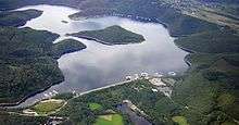 Aerial shot of the Rur Dam, Schwammenauel and Rur Reservoir with the Tonsberg peninsula (left centre), island of Eichert (centre) and peninsula of Eschauel (rear right) | |
| Location | Städteregion Aachen, Kreis Düren |
| Coordinates | 50°37′57″N 6°23′55″E / 50.63250°N 6.39861°ECoordinates: 50°37′57″N 6°23′55″E / 50.63250°N 6.39861°E |
| Construction began |
1934–1938, 1955–1959 and 1961 |
| Dam and spillways | |
| Impounds | Rur; others see below |
| Height (foundation) | 77.2 m (253 ft) |
| Height (thalweg) | 69.5 m (228 ft) |
| Length | 480 m (1,570 ft) |
| Elevation at crest | 284.43 m (933.2 ft) |
| Width (crest) | 15 m (49 ft) |
| Dam volume | 2.6×10⁶ m3 (92×106 cu ft) |
| Reservoir | |
| Total capacity | 203.2×10⁶ m3 (7.18×10⁹ cu ft) |
| Active capacity | incl. Obersee 202.6×10⁶ m3 (7.15×10⁹ cu ft) |
| Catchment area | 288.1 km3 (69.1 cu mi) |
| Surface area | 7.83 km2 (3.02 sq mi) |
| Max. length | 10.6 km (6.6 mi) |
| Normal elevation | 281.5 m (924 ft) |
The Rur Dam (German: Rurtalsperre Schwammenauel) is a 77.2 metre high dam located in the southwestern part of the state of North Rhine-Westphalia in Germany. It was built in 1939 and impounds the River Rur to form the Rur Reservoir (Rurstausee or Rursee) which is 7.83 km² in area. It lies within the districts of Aachen and Düren.
Headwaters and tailwaters
The headwaters of the Rur Reservoir, with their length in kilometres (km), according to the Deutsche Grundkarte map (sorted alphabetically):[1]
- Allersbach (2.9 km); from Buhlert Ridge flowing from the west-northwest, empties into the central section of the reservoir
- Büdenbach (1.1 km); from the Kermeter flowing from the south, discharges near the dam wall in the northeastern part of the reservoir
- Eschbach (1 km); from the Kermeter flowing from the south, empties into the northeastern part of the reservoir
- Hohenbach (2.1 km); from the Kermeter flowing from the south, empties into the northeastern part of the reservoir
- Lederbach (1.1 km); from the Buhlert Ridge near the hamlet of Klaus flowing from the northwest, discharges into the central part of the reservoir
- Morsbach (1.2 km); from Schmidt-Eschauel flowing from the north, discharges into the central part of the reservoir
- Rur (164.5 km), the main headwater, flowing from the south and emptying into the southern end of the reservoir; forms the only natural tailwater
- Welchenbach (3.5 km); from the Monschauer Heckenland/from the direction of Simmerath in the west, discharges into the southern part of the reservoir
- Wolfsbach (2.2 km); from the Monschauer Heckenland/from Steckenborn (Simmerath) flowing from the west, discharges into the southern part of the reservoir
- Schilsbach, from Hechelscheidt/ Klaus, empties near Woffelsbach/ Schilsbachtal
- Weidenbach, empties near Rurberg/ Weidenbachtal
See also
References
- ↑ Rurtalsperre Schwammenauel (accessed on 30 December 2011)
Literature
- Talsperren in der Bundesrepublik Deutschland, Peter Franke, Wolfgang Frey: DNK - DVWK 1987, ISBN 3-926520-00-0
External links
| Wikimedia Commons has media related to Rur Dam. |
- NRW dam information
- Available measurement stations and time series for the Rur Dam at wver.de
- Webcam with view from Buoy 2 towards Buoy 1
- Water gauge and weather data
- RWTH weather station with webcam of the Woffelsbach Bay
This article is issued from Wikipedia - version of the 8/14/2016. The text is available under the Creative Commons Attribution/Share Alike but additional terms may apply for the media files.