Rupnagar district
| Rupnagar district ਰੂਪਨਗਰ ਜ਼ਿਲ੍ਹਾ | |
|---|---|
| District | |
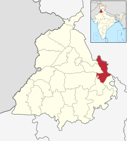 Location in Punjab, India | |
| Coordinates: 30°58′N 76°31′E / 30.97°N 76.51°ECoordinates: 30°58′N 76°31′E / 30.97°N 76.51°E | |
| Country |
|
| State | Punjab |
| Named for | Raja Rokeshar's son, Rup Sen |
| Headquarters | Rupnagar |
| Government | |
| • Administrator of District | Karinesh Sharma |
| Area | |
| • Total | 1,440 km2 (560 sq mi) |
| Population (2011)‡[›] | |
| • Total | 684,627 |
| • Density | 480/km2 (1,200/sq mi) |
| Languages | |
| • Official | Punjabi |
| Time zone | IST (UTC+5:30) |
| ISO 3166 code | IN-PB-RU |
| Literacy | 82.19% |
| Website |
rupnagar |

Rupnagar district (Doabi: ਰੂਪਨਗਰ ਜ਼ਿਲ੍ਹਾ) is one of the twenty two districts in the state of Punjab in North-West Republic of India. The town of Rupnagar (formerly known as Rupar or Ropar) is said to have been founded by a Raja called Rokeshar, who ruled during the 11th century and named it after his son Rup Sen. It is also the site of an ancient town of the Indus Valley Civilization. The major cities in Ropar District are Morinda, Nangal, Kurali, Anandpur Sahib. Morinda is also known as Baghawala "The City of Gardens." Morinda is located at Chandigarh-Ludhiana Highway.
Rupar
Rupar is a 21 metre high ancient mound overlaying the Shiwalik (also spelt as Sivalik or Shivalik) deposition on the left bank of the river Sutlej where it merges into the plains. It has yielded a sequence of six cultural periods or phases with some breaks from the Harappan times to the present day. The excavations were carried out by Dr. Y.D. Sharma of Archaeological Survey of India. The migration of the Harappans to Rupar has been postulated through the lost Saraswati River to the Sutlej as both rivers once belonged to one system.
Period I
At Rupar excavation, the lowest levels yielded the Harappan traits in Period 1, which falls in the proto-historic period. A major find was a steatite seal in the Indus script used for the authentication of trading goods, impression of seal on a terracotta lump of burnt clay, chert blades, copper implements, terracotta beads and bangles and typical standardized pottery of Indus Valley Civilization. They flourished in all the Harappan cities and townships.
The dead were buried with head generally to the north and with funerary vessels as unearthed in cemetery R-37 at Harappa (Sind, Pakistan). What led the Harappans to desert the site is not known.
Period II
Period II belongs to Painted grey ware people who followed the Harappans. Typical pottery of this period consisted of fine greyware painted black, terracotta bangles, semi precious stones, glass, bone arrowheads, ivory kohl sticks and copper implements. This period is identified as the period belonging to the Great War Epic - Mahabharata.
A new settlement sprang up here by about 600 BC - chronologically Period III at Rupar. Grey pottery of Period II still continued. This period belongs to circa 600 BC to 200 BC. It yielded the earlier coins (punch marked and uninscribed cast coins), copper and implements. An important find was an ivory seal inscribed in Mauryan Brahmi script (4th and 3rd century BC)
Minutely carved and polished stone discs with a figure and motif associated with the cult of the Mother goddess of fertility have also been unearthed in the excavations from Taxila (now in Pakistan), Patna in the state of Bihar and other Mauryan sites. Houses of mud and kiln burnt bricks were by no means rare. A 3.6 metre wide burnt brick wall traced to a length of about 75 mts probably endorsed a tank which collected water through inlets. The upper levels have soak wells lined with terracotta rings of Shunga and Kushana periods.
Period III To V
From Period III to V there are fairly rich dwelling complexes with houses of stone and mud bricks. The full plans of the houses could not be exposed owing to the vertical nature of excavations carried out.
Period VI
The next phase, Period VI revealed the evidence of the Shungas, Kushanas and Guptas and their successors. Excavations also revealed successive building levels of various dynasties. In the upper levels a hoard of copper coins of Kushan and Gupta rules were found. This includes a gold coin issued by Chandragupta-Kumerdevi of the Gupta dynasty, which is also known as the golden age in ancient Indian history.
A large number of terracotta figurines of Shunga, Kushana and Gupta periods were also discovered. Amongst them was a Yakshi figure with cherubic expression and a beautiful seated figure of a lady playing on the lyre reminiscent of Samudragupta’s figure in a similar position on the famous gold coins of the Gupta dynasty. A set of three silver utensils for ritualistic purpose with Greek influence depicts the fine craftsmanship of the Gupta dynasty in its chased decoration.
The pottery of this period in the upper levels is for the most part red ware and is frequently decorated with incised motifs. After a short break, there is evidence of a fresh occupation identified as Period V commencing around the early 6th century and continuing for three or four centuries. The coins of Toramana (circa AD 500) and Mihirakula (circa 510-40) have been recovered from these levels. The spacious brick building of the fifth period were constricted neatly and evidences showed a good measure of prosperity during this period.
Probably after desertion, a new town sprang up here around 13th century AD on the same site named Period VI and it continues to flourish to the present day.
An archaeological site museum has been set up to house some of the antiquities of Rupar along with the photographs displaying excavation material.
Location

Rupnagar district, included in the Patiala Division of Punjab falls between north latitude 30°-32' and 31°-24' and east longitude 76°-18' and 76°-55'. Rupnagar (formerly known as Ropar) town, the district headquarters is 42 km from Chandigarh, the state capital. The district adjoins Shahid Bhagat Singh Nagar (formerly known as Nawanshahar), Mohali and Fatehgarh Sahib Districts of Punjab. The district comprises 4 Tehsils, Rupnagar, Anandpur Sahib, Chamkaur Sahib and Nangal and includes 617 villages and 6 towns namely Rupnagar, Chamkaur Sahib, Anandpur sahib, Morinda, Kiratpur Sahib and Nangal. All the towns except Chamkaur sahib fall on railways line. The Satluj river passes close (2 to 5 km) to the towns of Nangal, Rupnagar and Anandpur Sahib.
Towns and villages

Rupnagar district, included in the Rupnagar Division of Punjab falls between north latitude 30°-32' and 31°-24' and east longitude 76°-18' and 76°-55'. Rupnagar (formerly known as Ropar) town, the district headquarters is 42 km from Chandigarh, the state capital. The district adjoins Nawanshahar, Mohali and Fatehgarh Sahib Districts of Punjab. The district comprises four Tehsils, Rupnagar, Anandpur Sahib, Chamkaur Sahib and Nangal and includes 617 villages and 6 towns: Rupnagar, Chamkaur Sahib, Anandpur Sahib, Morinda, Kiratpur Sahib and Nangal. All the towns except Chamkaur Sahib have railway connections. The Satluj river passes close to the towns of Nangal, Rupnagar and Anandpur Sahib.
Climate
The climate of Rupnagar District is characterized by its general dryness (except in the south-west monsoon season), a hot summer and a bracing cold winter. The year may be divided into four seasons. The period from about middle of November to February is the cold season. This is followed by the summer season from March to about the end of June. The south-west monsoon season commences late in June and continues up to about middle of September. The period from mid September to the middle of November constitute the post-monsoon or transition season. The temperature ranges from minimum of 4 °C in winter to 45 °C in summer. May and June are generally hottest months and December and January are the coldest months. Relative humidity is high, averaging about 70 percent during monsoon. The average annual rainfall in district is 775.6 mm. About 78 percent of the annual rainfall is received during the period from June to September. The soils of the District vary in texture generally from loam to silty clay loam except along the Sutlej River and chos where some sandy patches may be found. Chamkaur Sahib and Kharar blocks have sodic soils. The soils of Anandpur Sahib and Rupnagar blocks are undulating.
Tehsils in Rupnagar District
Cities and towns
- Anandpur Sahib
- Chamkaur Sahib
- Kiratpur Sahib
- Morinda
- Nangal
- Rupnagar
- Kamalpur
- Ghanauli
- Dadhi
- Bharatgarh
- Kartarpur
Demographics
According to the 2011 census Rupnagar district has a population of 683,349,[1] roughly equal to the nation of Equatorial Guinea[2] or the US state of North Dakota.[3] This gives it a ranking of 507th in India (out of a total of 640).[1] The district has a population density of 488 inhabitants per square kilometre (1,260/sq mi) .[1] Its population growth rate over the decade 2001-2011 was 8.67%.[1] Rupnagar has a sex ratio of 913 females for every 1000 males,[1] and a literacy rate of 83.3%.[1]
Famous People from District
- Kanshi Ram founder of Bahujan Samaj Party hails from Ropar.[4]
References
- 1 2 3 4 5 6 "District Census 2011". Census2011.co.in. 2011. Retrieved 2011-09-30.
- ↑ US Directorate of Intelligence. "Country Comparison:Population". Retrieved 2011-10-01.
Equatorial Guinea 668,225, July 2011 est.
- ↑ "2010 Resident Population Data". U. S. Census Bureau. Retrieved 2011-09-30.
North Dakota 672,591
- ↑ "Kanshiram was born in Pirthipur Bunga village, Khawaspur, Ropar district, on 15 March 1934, to Bishan Kaur and Hari Singh.".
External links
| Wikimedia Commons has media related to Rupnagar district. |
-
 Chisholm, Hugh, ed. (1911). "Rupar". Encyclopædia Britannica. 23 (11th ed.). Cambridge University Press. p. 855.
 - Govt. Website on Rupnagar
- Rupnagar BSNL telephone directory search
- Archaeological Museum in Rupnagar (Archaeological Survey of India)

| Topics |
|  |
|---|---|---|
| Regions | ||
| Districts | ||
| Major Cities | ||