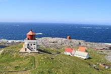
Runde Lighthouse
 Runde Lighthouse | |
 Møre og Romsdal | |
| Location |
Herøy, Møre og Romsdal Norway |
|---|---|
| Coordinates | 62°24′47″N 5°35′13″E / 62.413048°N 5.586839°E |
| Year first constructed |
1767 (first) 1826 (second) 1858 (third) |
| Year first lit | 1935 (current) |
| Automated | 2002 |
| Construction | masonry |
| Tower shape | square tower with balcony and lantern |
| Markings / pattern | white tower, red lantern |
| Height | 14 metres (46 ft) |
| Focal height | 49.5 metres (162 ft) |
| Intensity | 200,200 cd |
| Range |
white: 19 nautical miles (35 km; 22 mi) red: 15 nautical miles (28 km; 17 mi) green: 16 nautical miles (30 km; 18 mi)[1] |
| Characteristic | Oc WRG 6s. |
| Admiralty number | L0722 |
| NGA number | 6024 |
| ARLHS number | NOR-050 |
| Norway number | NF-3270[2] |
Runde Lighthouse (Norwegian: Runde fyr) is a coastal lighthouse located on the island Runde in the municipality of Herøy in Møre og Romsdal, Norway. It was first lit in 1767. The lighthouse was automated in 2002; the residential buildings were vacated and have since been used as a self-service tourist station.[3]
See also
References
- ↑ Runde Lighthouse leuchtturmseiten.de
- ↑ Rowlett, Russ. "Lighthouses of Norway: Ålesund Area". The Lighthouse Directory. University of North Carolina at Chapel Hill. Retrieved February 27, 2016.
- ↑ Henriksen, Petter (ed.). "Runde fyr". Store norske leksikon (in Norwegian). Oslo: Kunnskapsforlaget. Retrieved 29 September 2011.
External links
- Norsk Fyrhistorisk Forening (Norwegian)
| Wikimedia Commons has media related to Runde fyr. |
This article is issued from Wikipedia - version of the 6/30/2016. The text is available under the Creative Commons Attribution/Share Alike but additional terms may apply for the media files.