Rumoi, Hokkaido
| Rumoi 留萌市 | ||
|---|---|---|
| City | ||
| ||
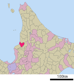 Location of Rumoi in Hokkaido (Rumoi Subprefecture) | ||
 Rumoi Location in Japan | ||
| Coordinates: 43°56′N 141°38′E / 43.933°N 141.633°ECoordinates: 43°56′N 141°38′E / 43.933°N 141.633°E | ||
| Country | Japan | |
| Region | Hokkaido | |
| Prefecture | Hokkaido (Rumoi Subprefecture) | |
| Government | ||
| • Mayor | Sadatoshi Takahashi | |
| Area | ||
| • Total | 297.44 km2 (114.84 sq mi) | |
| Population (March 2008) | ||
| • Total | 26,017 | |
| • Density | 87.5/km2 (227/sq mi) | |
| Symbols | ||
| • Tree | Acacia | |
| • Flower | Azalea | |
| Time zone | Japan Standard Time (UTC+9) | |
| City hall address |
1-11, Saiwaichō, Rumoi-shi, Hokkaidō 077-8601 | |
| Website |
www | |

Rumoi (留萌市 Rumoi-shi) is a city located in Rumoi Subprefecture, Hokkaido, Japan. It is the capital of Rumoi Subprefecture.
As of 2008, the city has an estimated population of 26,017 and the density of 87.5 persons per km². The total area is 297.44 km².
History
Rumoi was developed by herring fishery and mining.[1]
- 1869 Rurumoppe was renamed Rumoi.
- 1877 The village of Rumoi was founded.
- 1907 Sandomari village was merged into Rumoi village.
- 1908 Rumoi village became Rumoi town.
- 1914 The capital of Mashike Subprefecture was transferred from Mashike to Rumoi and Mashike Subprefecture was renamed Rumoi Subprefecture.
- 1947 Rumoi town became Rumoi city.
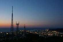 View of Downtown Rumoi from Senbou Hill in night |
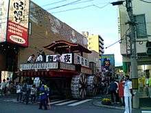 Andon yatai in Rumoi Dontou Festival on July |
Geography
Rumoi is located in the south of Rumoi Subprefecture. Rumoi River flows through the city.
Climate
Rumoi has a humid continental climate (Köppen climate classification Dfb) with warm summers and cold winters. Precipitation is significant throughout the year, but is heaviest from August to December.
| Climate data for Rumoi | |||||||||||||
|---|---|---|---|---|---|---|---|---|---|---|---|---|---|
| Month | Jan | Feb | Mar | Apr | May | Jun | Jul | Aug | Sep | Oct | Nov | Dec | Year |
| Average high °C (°F) | −1.9 (28.6) |
−1.5 (29.3) |
2.4 (36.3) |
9.2 (48.6) |
14.9 (58.8) |
18.5 (65.3) |
22.6 (72.7) |
24.4 (75.9) |
20.6 (69.1) |
14.5 (58.1) |
7.3 (45.1) |
1.3 (34.3) |
11.03 (51.84) |
| Daily mean °C (°F) | −5.1 (22.8) |
−4.9 (23.2) |
−0.9 (30.4) |
5.2 (41.4) |
10.5 (50.9) |
14.7 (58.5) |
19.0 (66.2) |
20.6 (69.1) |
16.3 (61.3) |
10.3 (50.5) |
3.9 (39) |
−1.6 (29.1) |
7.33 (45.2) |
| Average low °C (°F) | −8.8 (16.2) |
−8.9 (16) |
−4.7 (23.5) |
1.3 (34.3) |
6.3 (43.3) |
11.3 (52.3) |
16.0 (60.8) |
17.3 (63.1) |
12.1 (53.8) |
6.0 (42.8) |
0.6 (33.1) |
−4.6 (23.7) |
3.66 (38.58) |
| Average precipitation mm (inches) | 108.8 (4.283) |
76.7 (3.02) |
61.0 (2.402) |
53.3 (2.098) |
60.9 (2.398) |
66.0 (2.598) |
94.1 (3.705) |
148.4 (5.843) |
147.1 (5.791) |
142.3 (5.602) |
144.0 (5.669) |
136.7 (5.382) |
1,239.3 (48.791) |
| Average snowfall cm (inches) | 150 (59.1) |
103 (40.6) |
57 (22.4) |
6 (2.4) |
0 (0) |
0 (0) |
0 (0) |
0 (0) |
0 (0) |
1 (0.4) |
36 (14.2) |
126 (49.6) |
479 (188.7) |
| Average precipitation days (≥ 1.0 mm) | 21.4 | 17.1 | 14.2 | 9.1 | 9.5 | 8.7 | 8.9 | 10.0 | 12.7 | 15.6 | 19.4 | 22.4 | 169 |
| Average snowy days | 28.0 | 24.1 | 23.5 | 6.8 | 0.3 | 0 | 0 | 0 | 0 | 1.9 | 14.9 | 26.6 | 126.1 |
| Average relative humidity (%) | 77 | 76 | 73 | 71 | 74 | 82 | 83 | 83 | 78 | 73 | 73 | 77 | 76.7 |
| Mean monthly sunshine hours | 50.6 | 76.6 | 141.2 | 170.8 | 190.4 | 181.9 | 172.7 | 172.5 | 174.7 | 130.1 | 53.5 | 30.2 | 1,545.2 |
| Percent possible sunshine | 18 | 26 | 39 | 43 | 42 | 40 | 37 | 40 | 47 | 38 | 19 | 11 | 35 |
| Source: NOAA (1961–1990)[2] | |||||||||||||
Average wind speed by month (Annual average: 4.9 m/s or 18 km/h or 11 mph)
| Month | m/s | km/h | mph |
|---|---|---|---|
| January | 6.1 | 22 | 14 |
| February | 5.3 | 19 | 12 |
| March | 4.9 | 18 | 11 |
| April | 4.8 | 17 | 11 |
| May | 4.2 | 15 | 9 |
| June | 3.5 | 13 | 8 |
| July | 3.4 | 12 | 8 |
| August | 3.8 | 14 | 9 |
| September | 4.5 | 16 | 10 |
| October | 5.8 | 21 | 13 |
| November | 6.5 | 23 | 15 |
| December | 6.5 | 23 | 15 |
Transportation
- JR Hokkaido Station
- Fukagawa-Rumoi Expressway
- Port of Rumoi
Education
High School
- Hokkaido Rumoi High School
- Hokkaido Rumoi Sembo High School
Sister city
![]() Ulan-Ude, Buryatia, Russia (since 5 July 1972)[3]
Ulan-Ude, Buryatia, Russia (since 5 July 1972)[3]
References
- ↑ The history of Rumoi
- ↑ "Rumoi Climate Normals 1961–1990". National Oceanic and Atmospheric Administration. Retrieved December 29, 2012.
- ↑ International exchange of Rumoi
External links
 Media related to Rumoi, Hokkaidō at Wikimedia Commons
- (Japanese) Official website
This article is issued from Wikipedia - version of the 10/12/2016. The text is available under the Creative Commons Attribution/Share Alike but additional terms may apply for the media files.